
Garry English, Fleming Grove Road, Gibson
|
|
Coramup Creek protection
Garry English, Fleming Grove Road, Gibson |
 The Site
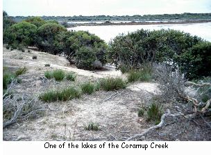
Garry English started developing his original farm on the Coramup Creek for cropping and sheep in 1976. It was first released in 1961 and had been partly cleared by a previous owner. He purchased a block further south on the creek in 1991 and has been upgrading it since then. The Coramup Creek runs partially through both properties and has a chain of lakes along its length. The lakes are different in character, although all of them are saline to some extent. The creek is more saline during the winter as salt flows down from the salt lakes to the north. Most of them are shallow, so they dry up quickly after rains, but when they do hold water they provide a habitat for many species of water bird. The water flows more slowly along the northern part of the creek, as the topography is fairly flat. Whereas in the southern section it is narrower and steeper and the velocity of the water is increased. The creek is the approximate boundary for the transitional zone between mallee vegetation to the east and sand plain vegetation to the west. The Coramup Creek flows into the Warden Lakes system near Esperance where it flows out onto a floodplain. The riparian vegetation ranges from degraded to healthy along the length of creek in Garry's farm. The catchment has less than 5% native vegetation remaining.
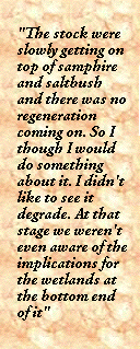
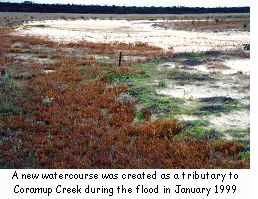
Garry noticed in 1985 that on his original block "the stock were slowly getting on top of samphire and saltbush and there was no regeneration coming on. So I thought I would do something about it. I didn't like to see it degrade. At that stage we weren't even aware of the implications for the wetlands at the bottom end of it (Lake Warden)". He also noticed that a lot more water was flowing down the creek than there used to be. "The fact that it's all cleared [means] there could be up to ten times more water coming through in a rush. The total volume coming down is probably not greatly more than what it would have been initially, but it sheds off that much quicker than the natural system. We've seen the roads go underwater several times in the last ten years. Prior to that we didn't see the roads go underwater, they didn't get washed out". During January 1999 the Esperance region experienced a major flood and Garry's property received massive damage. A new watercourse was created as a tributary to the Coramup Creek and that caused a lot of damage to one of the paddocks. The new tributary was over two kilometres long and Garry says, "there must have been water going through here very slowly over the years but never to this extent. It has really changed a lot of things around here". He had to put gravel down on a track to access the paddock and fill in huge washouts. Fortunately there hasn't been any water flow down the new tributary since the flood.
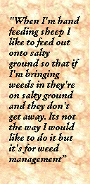
Garry believes that the flood was so big that, "the vegetation on the eastern bank slowed it down too much and made it jump outside the creek and that is what caused the erosion problem. Further upstream the water was able to run through the original channel because the natural vegetation wasn't there; it's all dead. As soon as it hit this area where the vegetation was very thick it just couldn't handle it and it jumped straight out of the bank, outside of the original channel and eroded. The original channel was 3-4 metres wide, very defined, it was very pretty and full of vegetation". Garry had already done some landcare work at the site in about 1996. "The paddock was cropped up to about 30 metres from the vegetation line on the edge of the creek, which was fenced four to five years ago. I thought that was fairly reasonable, never dreamt this would happen. So we lost the fence, lost the 2500 trees we had planted on here. Everything has just gone down the creek, so we've started again. The idea is just to fence the whole thing out again". The Solution Over the past 15 years Garry has put in about 25 kilometres of fencing in stages on the Coramup Creek. He has also fenced many of the smaller tributaries. The majority of the work has been self-funded except for a small grant recently from the Natural Heritage Trust as part of the Lake Warden System Project. He has done some revegetation with direct seeding and planting in some parts but has mainly relied on natural regeneration. "As long as there's a few old paperbarks around that drop a few seeds it's amazing how suddenly it regenerates". He has found that the regeneration in some areas is slow and has supplemented it with melaleuca, casuarina and eucalypts. Garry says that the reason why a lot of the creek was actually grazed and subsequently became a bit degraded was that fencing the tributaries was very inefficient as far as economics go and a lot of fence had to go into a very small area. The wetland areas on Garry's southern property have been fenced since 1991 when Garry first bought the property. He has noticed that the paperbarks are regenerating well. He also planted yates, Casuarina obesa and melaleucas during 1999. The ground was sprayed for weeds twice with "Roundup" early in the year and seedlings were planted by hand using a wedge. When Garry is fencing off his wetland areas he leaves a small piece of salt-affected land unfenced. "When I'm hand feeding sheep I like to feed out onto salty ground so that if I'm bringing weeds in they're on salty ground and they don't get away. Its not the way I would like to do it but it's for weed management. I've found in the past that one of my biggest problems is, if we have had a drought year and I buy in seed I bring in radish and all sorts of other things from elsewhere. That is why I'm feeding out on the salt ground. So I leave a little bit of salt if I can". Garry has also been managing the water on his farm using contours. "I've tried to manage the water shedding off the higher ground by putting in a whole lot of contours, trying to slow down that rush of water". He has filled in the scours in one of the badly eroded paddocks with a scraper. These were a couple of metres wide and a metre deep. Afterwards he put in contours to get the water to run down gently into the creek. After the major flood and subsequent erosion of the Coramup Creek, Steve Janicke and Neil Blake from the Water and Rivers Commission surveyed a centre to the new channel. This was an attempt to train the river back into a stable channel, otherwise they believed that it would keep meandering mainly at the lower end and would end up eroding further into the paddock. Steve explained that, "One purpose of the survey was to be able to measure changes to the site over subsequent years and to see how small, low cost adjustments can be employed to keep the flow controlled. Stabilising large sandy channels is a daunting prospect and we felt that Garry's work would provide a valuable insight into managing channel structure under the relatively new catchment runoff conditions now common to many South Coast waterways. The main area of flood damage was surveyed to see if it was feasible to consider retraining water back into the old channel on the eastern side. The levels revealed that the flood scouring had eroded the valley side down to the same bed level as the original channel and that efforts to retrain it that way would be very expensive, time consuming and likely to fail. The survey also picked up the tendency of the new low flow channel and so it appeared that this was the new scenario to work with.
Given the increased demand on the channel from water running off the catchment the response of this particular site to the flood illustrated the need to reduce, slow and also accommodate the flow. We have found also that channels that have become constricted with vegetation over years of low to moderate flows may need some low key intervention, for example sensitively moving material in the central channel to other unstable sites along banks. However it is important to note that freeing up the flow will increase its velocity and therefore its capacity to do damage further downstream. One thing that was very noticeable after the floods was the resilience of native sedges to the extreme power of the river flows. The paperbarks received a thrashing but where they were growing in close communities they held their position. While some species are a nuisance in paddocks, sedges for channel stabilisation may prove to be a valuable, low cost, low maintenance resource. They lie down in the flood flow, armouring the bed without damming the flow, then spring back after the flow has slowed". After the survey and before winter 1999 Garry formed a narrow channel with a grader blade in the channel to try and direct the water. This worked well until there were more heavy rains and it jumped out of the grader channel and began eroding the bank further.
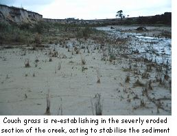
There is still a lot of sand in the creek channel that will continue to move down the creek over time. Garry has noticed that the natural regeneration has been extensive and the growth in the channel is now starting to control further erosion. He has also noticed that couch grass is re-establishing in the severely eroded section of the creek and this is acting to stabilise the sediment. He believes that given another twelve months without a major flood it will be stabilised. Garry will also re-fence this part of the creek so there is a 100 metre wide buffer from the original creek.
Owing to the 1999 flood Garry has experienced some major disappointments with his landcare work but he is keen to keep going. He has also been encouraging others in the catchment to become involved through the Lake Warden NHT Project. Over the years he has noticed quite a bit of regeneration in the fenced off areas particularly with the paperbarks and mallees re-sprouting. However, "Kangaroos have become a bit of a problem. Since I've fenced it all out we've got more kangaroos than our share". As far as the creeklines go Garry says, "It's always hard to know just how far out you should go with the fencing. But the whole creek is protected on this place now. It's amazing how it's just rehabilitating itself". "I hope by fencing them that I can just walk away from them rather than having stock just continually walking through and chipping away at it. When you get another big rainfall event it washes more soil away if you haven't got any stabilisation". Coramup Creek catchment statistics
|
||||||||||||||||
 |
||||||||||||||||
 |
||||||||||||||||


 The Problem
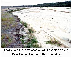 On the Coramup Creek itself there was massive erosion of a section about two kilometres long and about 80 - 100 metres wide. It scoured out sand to a depth of about 2.5 metres at the northern end and 1.5 metres deep on the southern end. Garry went down to the creek during the middle of the flood to see what was happening. "It was roaring water going through here. The sand was deposited all the way for the next ten kilometres. It's just amazing what happened here. You couldn't shift it in weeks with a scraper and it shifted it in a day".
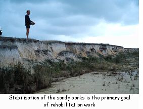 The capacity of the new channel is now so large that there is room to move within it as far as stabilisation works are concerned. Stabilisation of the sandy banks is the primary goal.
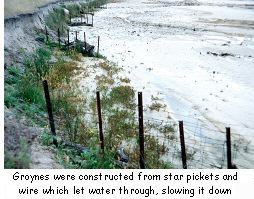 Garry then decided to take further action. "I've added to that and put in some simple little 'groins', which are very, very basic. It doesn't look like it would stop water or anything but it's had a terrific effect. The water has actually gone back down to the original channel and most of the water goes there". The 'groins' are constructed from star pickets and wire which let water through but also act to slow it down. He has put four pickets in a line at an angle to the water flow and they seem to be working well. "We have had an inch a day for about three days and a lot of water has gone down but it hasn't caused any further erosion". Garry didn't want to put in more solid groins as they may have created more erosion on the opposite bank. However he wishes he had made them six metres in length instead of three metres.
 The Outcomes and observations