
Brenda Berry and John Bamford, Valley of the Giants Road, Tingledale
|
|
Crooked Creek rehabilitation
Brenda Berry and John Bamford, Valley of the Giants Road, Tingledale |
 The Site
Brenda Berry and John Bamford purchased their 53 hectare cattle property in 1994 and began living on it in 1998. It is situated in the Walpole-Tingledale Land Conservation District catchment some 16 kilometres northeast of Walpole. The property has been used for cattle and sheep grazing since the 1950s. Two creeks run through the property, Little Bow Creek and a spring-fed tributary to the north. Originally Little Bow Creek was a braided stream that meandered through 200 metre wide flats of tea tree (Leptospermum), paperbark (Melaleuca), Albany bottlebrush (Callistemon speciosus), black butt (Eucalyptus patens) and rushes. During the 1950s the flats were cleared of much of the native vegetation and sown to pasture. Little Bow Creek has a catchment of some 2500 hectares, 2000 hectares of which is upstream, and it is 70% cleared of native vegetation. Most of the rainfall occurs during June to September and sheet flooding happens regularly, sometimes for two to three days at a time. Since moving to the property Brenda and John, with assistance from the local landcare group, have been working to alleviate the waterlogging and erosion problems on the floodplain of Little Bow Creek. The Problem The property is situated almost at the bottom end of the catchment and receives water from a large area upstream. The perceived threats from upstream include effluent discharge from a dairy farm and increased runoff from clearing. Prior to 1985 the low-lying areas of the property were completely waterlogged and not useable for grazing in winter and were still moist in summer. During 1985 the creek was modified by machine by a previous owner into one straight channel to enable the flats to be used for grazing. All the small tributaries were filled in with soil and the course of the main channel was straightened. Causeway pipes were installed at the same time to enable access to the house. These works resulted in major water erosion of the banks during subsequent winter flooding. The erosion channel was 2.5 - 3.0 metres deep and up to ten metres wide for the length of the 250 metre channel. Water would also sheet flood from the higher ground to the north across the spring fed creek and through the floodplain area causing soil erosion. On the eastern property boundary the creek flows into a Water Reserve and here the flow is slowed down by a well vegetated creek. This results in water backing up onto the property and the eastern section of the floodplain is not useable for grazing as it is too wet for most of the year.
During 1994 Brenda and John were approached by the Walpole-Tingledale Land Conservation District Committee (LCDC) about the erosion problem, which was seen as an eyesore so close to a major tourist route (the Valley of the Giants). In 1995 a grant to do conservation works was applied for through the National Landcare Program (NLP). The grant was approved and works began in 1997. The goals of the conservation works were to:
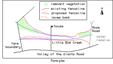
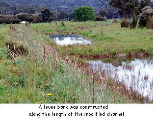
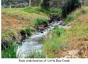
In April 1997 a bulldozer constructed a 1.5 metre high levee bank to the north of and along the length of the modified channel. This was constructed to contain the sheet runoff from the hills and stop it from further eroding the creek bank by diverting it along a different path. The levee bank was fenced temporarily and Kikuyu grass was sown to stabilise the banks. Grazing recommenced once the grass was established. Rocks were placed in the creek bed on the western boundary to prevent the erosion spreading upstream. Some revegetation was undertaken along the creekline. Fencing of the two creeks was completed to the west of the road access to the house. Fencing to the east is yet to be completed (see farm plan).
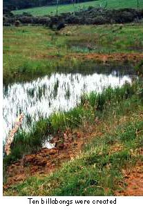
The upstream section of the creek on the western boundary was originally excavated with a sharp bend in it. Excessive erosion occurred there and so the channel was realigned. This dramatically decreased the erosion and together with the rock stabilisation further erosion of the creekbed has not occurred. The "battering" of the banks in this area has also prevented further bank erosion. The levee bank has been partially successful in that most of the erosion caused by water flowing off the hills to the north has been arrested. There is still some minor erosion of the banks that were not "battered" in the western portion of the creek. However Brenda and John feel that the levee bank could have been lower, up to one metre, and it should have been placed further north towards the spring-fed creek. Pasture on the northern side of the levee bank is now unusable for grazing for eight months of the year. Ten holes were created by the removal of soil for construction of the levee; they now hold water and are useless.
Brenda and John believe that there is still a lot more work necessary to further stabilise the site and increase the grazing area and they are planning to do the following:
Further works are planned by the LCDC using the remainder of the project funds.
Coramup Creek Catchment Statistics
Map Reference: 1:50 000, 2227 I and IV 2228 III |
||||||||||||||||
 |
||||||||||||||||
 |
||||||||||||||||


 The Solution
 The Outcomes and Observations
 Some work has been carried out on the house access causeway to level its surface. This has enabled higher flows to spill over in an even fashion without being concentrated in one place. This levelling work has arrested the erosion of the causeway during flooding.