
Dick and Janet Kuiper, West River
|
|
West River tributary restoration
Dick and Janet Kuiper, West River |
|
The Site
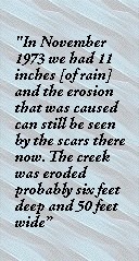
Dick and Janet Kuiper moved onto their farm on the west side of the West River forty years ago and developed it from native bushland. The West River reserve forms the eastern boundary of the property and a tributary runs through the farm from the southwest to the northeast. Most of the catchment for the tributary is contained within the property boundary. In March 1998 the West River Catchment project commenced with Natural Heritage Trust funding and fencing of remnant vegetation and replanting of native species has been ongoing. The landholders are also funding planting perennial pastures and conservation earthworks with the aim of protecting the West River and enhancing their farm production. During the 1980s the area experienced severe wind erosion problems and it was then that Dick and Jan first started the conservation works. With wind erosion mainly under control he then started working on water control over the whole farm. The Problem Since clearing, the area has experienced floods and wind erosion and these events have had a drastic effect on the creeklines. "In November 1973 we had 11 inches [of rain] and the erosion that was caused can still be seen by the scars there now. The creek was eroded probably six feet deep and 50 feet wide. The creeks that were cleared originally and cropped through, well they washed out and eroded badly. We then got wind erosion and that half filled them back up again. So we ended up fencing both sides off trying to save the trees, but nothing came up". Dick has noticed that the remnant vegetation in the creeklines has been declining since clearing. "When we cleared around that [part of the creekline] in the mid 80s it was pristine vegetation with yates and it's just about dead now. It has been fenced off for quite a while, there were fresh water pools there and they are now dead salt scalds and the water lies there all year. In another part of the creekline Dick recalls that, "When we originally cleared the land we left the creekline because it was really beautiful. Unfortunately a fire got away and burnt about half the creekline and it was the start of the finish. It never regenerated because as it was trying to grow the salt started to rise and the yates were trying to re-shoot at the same time as they were dying off. If the fire hadn't got in there it would have lasted longer. We had sheep in the creekline and it was lightly grazed and then we got fencing funding in the late 1980s to fence it totally. For a while it started to pick up and then we had a few wet years in the early 1990s and that was the last nail in the coffin. Within 18 months it died".
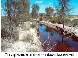
The first work Dick and Jan carried out to alleviate the erosion and vegetation decline in the creeklines was to fence some of them off. Part of the main creek was fenced in the mid 1980s and trees were planted. He thought that some of the plantings were failures but noticed that about 12 months after they were planted the trees started to grow up above the weeds. During the late 1980s a few kilometres of level Wisalt type banks were constructed in the paddock on the southeastern section of the main creekline. The aim was to keep water out of the creek by collecting and evaporating it in the banks. Dick says that he wouldn't do level banks again and now all the banks are grade banks to take the water away slowly. He says, however, that considering the level banks were put there to hold water and to evaporate it they had worked well. He has also tried some conservation earthworks in some parts of the creeklines. He carried out a small trial in the mid-1980s when he noticed that the vegetation in the creek was beginning to die. He was working in the paddock and noticed the trees going brown and he also noticed that the water in the creek was getting salty. He put a "three-point linkage" grader blade through a tributary to the creek and dug a channel about one metre deep and three metres wide. The drain is now always full of salt water and the water level doesn't change. On the area adjacent to the channel the vegetation has survived. "We've still got the vegetation growing up to it and that's what amazes me. We've only got about three metres of 'freeboard' here and yet we still have a lot of vegetation growing".
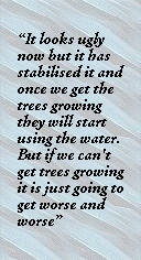
More recently in 1999 he had some earthworks done on another part of the creek where the vegetation had all died because of salt scalding. A bulldozer was used to push all the soil out of the creek and open it up following the natural waterway. During the operation the dead vegetation was buried beneath the spoil from the creek. Dick then planted about 4000 trees and since then he has noticed that there has been about another 4000 trees that have come up from stored seed. This is especially noticeable where the water has been lying around for a while. "Where it was salt scald previously we bought up fresh soil and let it drain and the trees have done well. The idea was to try and get it down to the clay. The water ran out of the creek for weeks after the channel was dug. It looks ugly now but it has stabilised it and once we get the trees growing they will start using the water. But if we can't get trees growing it is just going to get worse and worse".
Dick has now fenced most of the creeklines and will be finishing the rest as well as replacing some of the old fences. In an attempt to lower the water table Dick has planted lucerne in some of the paddocks adjacent to the main creekline. The Outcomes and Observations Dick has been a keen observer of the results of his various conservation works over the years and has experimented with different techniques. He believes that drainage is the way to fix the decline of vegetation in the creeklines. "It has worked where we got the dozer in and disturbed it all and drained it. All that I'm doing is putting salt water where it's going to end up anyway. I've been looking at the West River for 40 years and the only difference I've seen in the river since then is that the pools are always full of water now. As far as the vegetation goes there isn't any decline in the West River corridor". Dick has had variable results with direct seeding and would like to do more because he now knows more about controlling insects. He finds now that time and money is the holdup. "We've had to increase our cropping program to survive. I used to spend hours direct seeding trees and used to collect all the seed myself". Some of the creeklines have been fenced off for 20 years and they haven't regenerated well. Dick has noticed that weeds have taken over in these. "Some areas have been 20 years without stock but every year there are more weeds there". He is concerned about getting in and ripping in the riparian zone in case there is another wet summer and the soil is eroded further. "You could rip across but that's impractical. I think what we've got to do is really go back to basics and burn it and direct drill in sections each year, so if there is a big flood the erosion will be cut down. I'd cut a section of creek up and do it over three years and spray for weeds and then direct drill it with seed". By looking at the results of the piezometers Dick and Jan believe that the lucerne has definitely lowered the water table. "I still think this is something that we've got to push, to try and get lucerne or high water usage plants included, because just trees are not going to fix the problem". West River tributary catchment statistics
Map Reference: 1:50 000 2830 IV |
||||||||||||||||
 |
||||||||||||||||
 |
||||||||||||||||


 The Solution
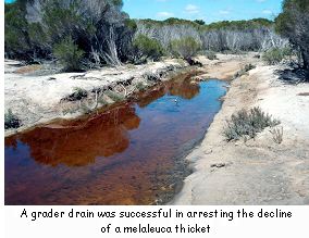
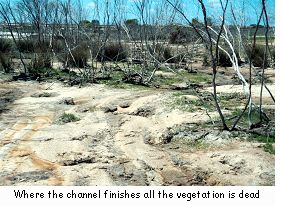 He also noticed that where the channel finishes all the vegetation is dead. Another grader drain was put in on the eastern boundary with the West River Reserve to try and address the decline of the riparian melaleuca thicket. This has been successful and the vegetation in the area is still surviving well.
 "You can't get trees growing on salt, but they only need a little bit of 'freeboard' to actually start growing". An excavator drain was dug in the late 1990s to drain water from a waterlogged area on the eastern end of the creek. This has proved successful and Dick has noticed that the vegetation decline has been halted adjacent to the drain.