 Background
Doug and Eva Russell purchased their 485 hectare property in 1996. They were attracted to it firstly because of the good soil, high rainfall and it was close to the coast. They were also attracted to the karri trees and the lake as they recognised their uniqueness in the area.
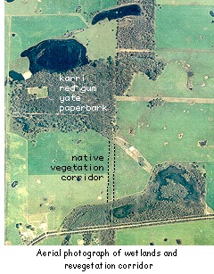
There are numerous fresh water wetlands on the property and in very wet years the excess water from these eventually flows into the Waychinnicup River and inlet nine kilometres to the southeast. The topography of the area is flat and there are very few defined watercourses. The catchment area for the wetlands is mostly within the property. The soil consists of light loam over clay or sand over loam. The original vegetation was karri (Eucalyptus diversicolor), yate (E. occidentalis), marri (E. calophylla) coastal jarrah (E. staeri), bullich (E. megacarpa) with paperbark (Melaleauca) around the wetlands. The state's most eastern stand of karri forest still occurs on the property and it covers about 47 hectares. The first settlers moved to the area in the 1950s as part of the War Service Land Settlement Scheme, and they described cells of karri forest that stood out above the low melaleucas.
It is now a registered Land for Wildlife property with the Department of Conservation and Land Management. Doug is also in the process of registering a covenant with the National Trust of Australia (WA) which will cover the 47 hectare patch of karri and the main lake, 24 hectares of paperbark wetland and a 2.5 hectare direct seeded corridor linking the two wetlands.
Doug has used the skills he built up on running his Narrikup Farm to carry out the conservation works on his current property. He also aims to improve these management skills with the new challenges posed by a new property.
The Problem
Doug was concerned about the wetlands becoming more degraded with his cattle having access to them. He had also lost six cows and calves during the first year when they became stuck in the muddy peat lake base. The lake had mostly dried out in 1996 and Doug believes that this has happened only twice before in the past 40 years.
When the farm was first cleared in the 1950s a hand-dug channel was constructed from the main lake to a smaller lake on the southern boundary. The owners at the time wanted to drain the lake, possibly to establish a vegetable growing area. This didn't work and Doug has pushed the bank in at two sites along the channel to ensure that the water level is retained should a high level occur in the future.
 The Solution
Doug believes that you "fence first to protect what is going to come up, the little seeds just need a chance".
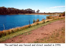
Almost as soon as they moved in during 1996 the Russells began fencing the largest lake to exclude cattle and thus protect both the water quality and the remaining and planted trees. Direct seeding was carried out along the northern edge of the lake after fencing with no prior preparation of the ground. The seedlings are now growing well.
To date 25% of the farm consists of either remnant vegetation or replanted areas, where 25 000 trees have been planted or sown. Nine kilometres of fencing has been completed, including laneways for cattle movement. All watering troughs are away from the lakes and stock do not have access to any of the wetlands.
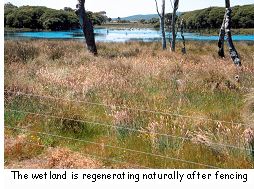 During 1997 Doug purchased a neighbouring property and fenced off a degraded wetland on the southern boundary with the assistance of the Gordon Reid Foundation. The wetland is now regenerating naturally.
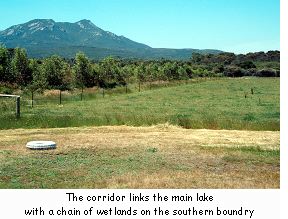
A 500 metre wide corridor of bare ground was fenced and direct seeded with twelve rows of native trees and shrubs in 1996 with the assistance of Greenskills. The corridor links the main lake and karri patch and the chain of wetlands on the southern boundary and will eventually provide for fauna movement across the farm.
Rabbits have not been a problem so far and control has not been necessary. Kangaroos have destroyed some of the trees and Doug believes he may have to think about culling them in the future.
The Outcomes and Observations
Doug is keen to share his experiences in rehabilitation and farm management. "You don't just look at the wetland, the water, you need to look at everything around it too". He has aimed for and been successful in creating an aesthetically pleasing environment and mixing it with farming.
 The benefits of the conservation work include provision of windbreaks for the cattle to protect them from the southwest and south easterlies. The plantings have been designed to stop the chill factor, which in turn decreases the cattle's food requirements. Doug believes that shade is not an issue in the mild climate experienced on the farm. No disadvantages to his stocking numbers have occurred even though some pasture has been replanted back to native vegetation.
If he were to start again, as far as the rehabilitation goes, Doug would move the fence out a further 30 metres on the northern edge of the main lake and plant more trees around the edge.
His future work includes direct seeding and infilling with native species where natural regeneration hasn't occurred, ongoing fence maintenance and carrying out weed control on the introduced grasses.
Doug has had birdwatchers from as far away as Bundaberg in Queensland visit the farm and he believes that access to wetlands generally is going to be more difficult in the future; he also believes that, "it's no good locking it up". In the future he would like to see a system of protected lands on private property that people can visit to learn and enjoy.
Main Lake Catchment Statistics
| Catchment area: | Local | |
| Type of wetland: | Lake | |
| Rainfall range: | 900-1000 mm./year | |
| Water quality: | Fresh | |
| Catchment disturbances: | Grazing, agroforestry, cropping |
Map Reference: 1:50 000 2528 III Plantagenet Location Lot 4 of 5307 and 5306