 The Site
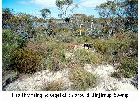
Location 1542 was surveyed as part of the War Settlement Scheme in the Shire of Jerramungup and clearing began in the area during the late 1950s. Anthony Thomas purchased the farm in 1985 and at that time most of the clearing had been completed. Jinjinnup Lake is a major feature of the farm and comprises 40 hectares of open water and approximately 40 hectares of fringing remnant vegetation that remains as a buffer around the southern, eastern and northern sides. At present it is still in a healthy state with yate (Eucalyptus occidentalis) being the dominant tree. The salinity is at a level between 40-80 milliSiemens/metre, so it is still quite fresh and is one of the freshest wetlands in the area. The lake supports a wide variety of birds including spoonbills, cormorants, ducks and little grassbirds, at least four species of frog and one species of crustacean.
The catchment for the lake is reasonably small and covers approximately 200 hectares of Anthony's farm and parts of three other farms. The major part of the catchment comprises heavy clay soils. The inflow to the north is a shallow floodway covered in yate woodland with no understorey on gravel over clay duplex soils. During high rainfall events the inflowing water covers an area 30 metre wide and one metre deep and has a reasonably high flow. The inflow is fenced except for stock access to a dam on the northern edge. In wet years the water from the lake flows via a creek on the southern edge into Yenteyerrup Lake, which is south of the Bremer Bay Road.
 The Problem
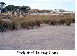
Three years after Anthony took over the farm there was a high rainfall event and about 80 hectares of grazing land was inundated from the outflow of the lake on the west-northwest side. Anthony believes that this was probably the first time it had happened as more land had been cleared in the catchment since the last high rainfall event. "Water came down and actually flowed out over about 200 acres of pasture and scoured out a bit of a hill and blew out a dam. We had put the dam in the year before a big rain, we didn't know it was in the middle of a watercourse". This caused huge problems for farm management as the low lying paddock area stayed flooded throughout the winter which excluding grazing. During summer there was no plant cover and as a consequence the area was subject to wind erosion.
 The Solution
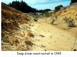
In an attempt to prevent the paddock becoming inundated in future wet years Anthony's father, Ken, came up with the idea of constructing a large excavator drain through a sand ridge on the southern edge of the lake. The work was carried out in September 1988. The drain is approximately 400 metres in length and it cost $6000. It is four metres deep close to the lake for about 100 metres and then it decreases gradually in depth until it meets the natural drainage line. Anthony funded the works himself, which at that time "was equal to a few bales of wool". The drain was fenced immediately to exclude stock, as the banks were unstable. For the next two winters in 1989 and 1990 the drain flowed because the lake was so full, but it hasn't flowed since the last wet year in 1993. Anthony pumped out some water for the dams during the dry years of 1994 and 1995, and during the summer of 1995-1996 the lake dried out completely.
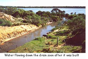 The drain has lowered the capacity of the lake by approximately 0.75 metres and the water no longer flows out over the paddocks but flows down the drain. This has effectively changed the site of the outflow but the water joins the natural watercourse a few metres to the south of the drain. Anthony has noticed that when the lake reaches the overflow level it just trickles down the drainage channel. During high rainfall events it does flow down rapidly, however, and Anthony has estimated the flow at 5000 litres per second during peak flow.
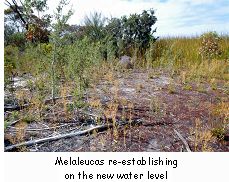
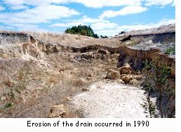
There is a line of melaleucas that have grown on the margins of the new lower water level and melaleucas have also colonised the base and sloping sides of the drain along its length. There was a problem with soil erosion when the drain was first constructed and the retaining wall was demolished. The resulting flush of water eroded the sides of the drain slightly and there was also some erosion of the base of the drain during the first two years after construction. Where the rock was at a deeper level on the southern end of the drain a small "waterfall" was formed and erosion is still occurring there to date. A quote of $120,000 for installing gabions was obtained through the Catchment Group to repair the erosion but this was considered by Anthony to be excessive. Consequently he has decided to do nothing at present, as the erosion does not appear to be getting much worse.
 As part of a Swamp Road Catchment Group National Heritage Trust grant Anthony is currently fencing and replanting the creek that takes the overflow water from the Lake to the Yenteyerrup Swamp to the south. He has completed the fence to his southern boundary and plans to plant yate and swamp paperbark in the creekline during the winter of 2000. Also as part of the funding Anthony has put a new fence about 10 metres out from the old fence on the western side of the lake where the fringing vegetation is only 40 metres wide. This area will be allowed to regenerate naturally and acacias are already coming up in the area.
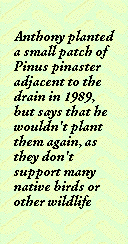
Anthony planted a small patch of Pinus pinaster adjacent to the drain in 1989, but says that he wouldn't plant them again, as they don't support many native birds or other wildlife. He has fenced a sand dune on the southern side of the lake and has planted blue gums and other eucalypts in an attempt to stabilise the sandy area and further buffer the lake. Anthony carries out some management of the natural vegetation surrounding the lake by periodic burning of small patches during autumn to break up the ages of the fuel.
 The Outcomes and Observations
Anthony is pleased with the drain and says that it has been successful because it has secured the farmland where the outflow water was inundating grazing land and the flow is also better controlled. In wet years he can now use the floodplain area, although water from surface runoff does still lie around in the depressions.
"The only thing that's a bit of a worry is the erosion where it drops over the edge [in the drainage channel], that probably needs stabilising. But apart from that it has done its job and it hasn't really effected the wetland, it is still in good nick. It's always good to have it here".
He believes that the wetland is still in good condition because he has kept stock out of the area since he took over the farm in 1985.
Jinjinnup Lake Catchment Statistics
| Catchment area: | 3000-4000 hectares | |
| Type of wetland: | Fresh water lake | |
| Rainfall: | 600 mm./year | |
| Water quality: | Fresh to marginal | |
| Catchment disturbances: | Stock grazing, cropping |
Map Reference: Location 1542 1:50 000 Map sheet 2729 III