 Background
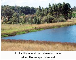
The Denmark Environment Centre was successful in getting funds from the Wilson Inlet Management Authority to carry out a rehabilitation project of an eroded dam overflow, visible from the South Coast Highway four kilometres west of Denmark. The dam is situated on the Little River on Broken Bridge Estate. The Little River is 10.5 kilometres in length and the water flows into the Wilson Inlet to the southeast. Approximately 62% of the Little River catchment has been cleared, mainly in the valleys, and the river is now 60-65% fenced. The salinity level of the river has been monitored for ten years and has not changed during that time.
Originally the river flowed through grazing property which was owned by the Hard family. The property has since been subdivided, the dam is on one property and the erosion channel is on the property owned by Kerry and Sue Saggers. In the late 1950s or early 1960s the Hard sons decided to build a dam on the river. After the dam was built they dug a channel to take the water out on the southern side of the dam, which then rejoined the main channel. The original river channel was to the north of the dam. A few remnant trees can still be seen along the old channel. When the first big floods occurred (probably within the first three years), the small channel was eroded into a channel 2-3 metres deep and 10-15 metres wide. The flow also formed two very deep circular pools just before it rejoins the original river channel.
In 1996 members of the Denmark Land Conservation District Committee and Environment Centre visited the site. The erosion looked terrible and they were concerned that if it wasn't arrested it would get much worse. The Environment Centre subsequently commissioned a rehabilitation report. The costs to do the recommended rehabilitation work came to around $14 000, which included rock emplacement, riffles and a fish ladder. Bob Gretton took over the project as part of the Little River Restoration Project and he asked Steve Janicke from the Water and Rivers Commission to visit the site. Steve looked at the site in November 1998 and recommended monitoring of the erosion to establish whether the channel was in fact stable or if it was still dynamic and eroding. Bob admitted that it looked horrific but questioned whether it was "really worth pouring $14,000-20,000 into a short reach of the river when that was all the money available for fencing for the whole river restoration project".
The Problem
The 100 metre long channel has incised and widened. The difficulty in assessing the extent of ongoing erosion is due to the lack of anything but anecdotal evidence and supposition.
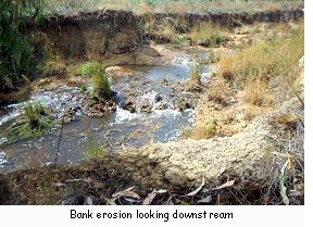 There are two levels of erosion evident in the channel; the high water flood level and the level of summer flow. When the river floods the water reaches the top of the bank, sweeps around a bend in the channel and it is sometimes in danger of breaking the bank and crossing a paddock to the southwest. The summer flow has created gullies, pools and erosion down lower in the channel. The water has now reached a fairly stable clay base that has slowed the downward erosion. Water reaches flood level regularly and stays high for weeks at a time several times per year. Every year there are flood events.
Monitoring
The monitoring option was agreed upon and a series of 300 millimetre pins were inserted into the banks at a few strategic places. Longitudinal and cross-sectional surveys were also carried out to establish what was going on with the bottom of the creek and also with the banks. Bob Gretton explained that "We now have base data which is 1999 pre-winter for what it really was like. We can re-run that survey [after winter] and we can say this bits changed, it's got deeper here or it's eroding really fast". A photographic record was also kept at strategic points.
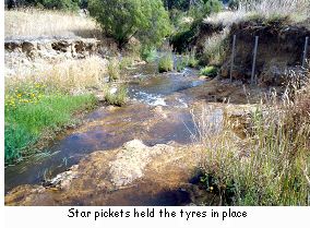 An experiment was carried out to see what would happen if the banks were protected by rocks, as was recommended in the rehabilitation report. Tyres held in place by steel pickets were put in at two places along the bank. They stayed in place from May to December 1999. "We did those two areas for protection of the bank and had pins behind them for monitoring purposes. The pins behind one tyre pile are still exactly as they were, there was no change, no erosion. Both the tyre walls changed the flood flows and took out a ton or two of soil on the opposite banks. The pins showed some exposure behind the tyres and there was also erosion upstream of the tyres. It's quite an interesting exercise because what it means is that if we put rocks in places where the erosion was bad, all that would happen is that we would cause a problem on the opposite bank. So unless you lined the whole creek with rocks you would just shift the problem from one place to another. What we found in the other areas that we've monitored with pins is there really isn't much movement in the soil. It's really an area that is fairly stable, it looks eroded, it looks terrible, but we've proved that it's reached a reasonably stable state".
In addition to the monitoring program an area of paddock to the west of the eroded channel was replanted in July 1999 to stabilise the area should a big flood occur. The area was ripped and mounded and trees were planted at one metre intervals. Local endemic lowland species were used, including various melaleucas, Eucalyptus patens, karri, Beaufortia sparsa and Callistemon glauca. Weed control was carried out prior to planting, using Roundup. Bob found that the timing of the work at this site was very difficult because the time between the first winter rains and the time when it was too wet to do anything was very short.
A second weed control was not carried out because it was close to the river and Bob was not happy using Simazine there. In January 2000 there was a high proportion of weeds at the site and Bob believes that if a second weed control had been carried out using Simazine there would be less weeds there now. However the planting has been successful and Bob feels confident that, "By this time next year, even if the water floods through here, there will be enough root system on these plants to hold it together. If within three or four years you have a hundred-year flood it would just flow through under these trees and shrubs".
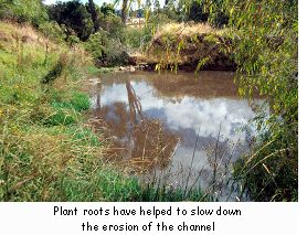 The creek bank has been further stabilised by the natural regeneration of peppermint (Agonis flexuosa) as the roots have helped to slow down the soil erosion.
The Outcomes and Observations
In relation to the original proposed river stabilisation works Bob says, "What we've learnt is that when you first look at things like this and contemplate solutions you really don't know what to do because you don't know what's happening. You presume that the erosion is fairly dynamic, but you don't know. You don't know what stage the process is at, whether it's still eroding or reached its natural shape and stabilised. With the monitoring program we proved that it's not eroding at a huge rate. We may still do some work in restoration or just leave it alone completely. We'll keep monitoring changes and assess changes. I think we could have saved $14,000 by doing $900 worth of monitoring and longitudinal surveys".
"It's a situation that I think a lot of new landowners would be in. I think it would be a really good warning for a new landowner not to presume they understand the history of the land too well without getting to know it. Thoughtful contemplation can pay dividends. Frantic action just to get in there and do something when you really don't know the way things are working on the property can be damaging or wasteful of resources".
"I think rehabilitation of areas like this is quite risky. You're working in fragile environments, the wettest areas; you're working right where the destructive forces of erosion during winter flows and floods can act on rehabilitation work and planting. Without care you could cause erosion when the objective of river restoration is obviously the opposite".
In hindsight Bob believes that the problem would have been much less severe if the water from the dam overflow had been directed back into the original creekline rather than into the new drain. "Trying to do your own thing with water is not easy whereas the old creekline is already established right up to the dam bank, there is a streamline going through. If they'd brought the water down the other side of the dam and dropped it into that streamline this problem may have been much less severe than it is now".
Little River Catchment Statistics
| Catchment area: | 3200 hectares | |
| Type of stream: | Perennial river | |
| Average rainfall: | 1100-1200 mm./year | |
| Water quality: | Fresh | |
| Catchment disturbances: | Vineyards, stock grazing |