
Denmark River, Hay River and Scotsdale Brook
|
Survey of riparian vegetation:
Denmark River, Hay River and Scotsdale Brook |
November 1997 |
The large quantities of nutrients and sediment that each year discharge into Wilson Inlet come principally from the Sleeman, Hay and Denmark Rivers, and the Cuppup Drain. These nutrients have a potential to cause algal growth which could smother the Ruppia seagrass meadows of the inlet. Research has highlighted the importance of streamline fringing vegetation in attenuating nutrient and sediment loss from agricultural areas into waterways. As a result there is an increasing call from the local rural community for the rivers and other watercourses of the catchment to be fenced. This would protect these large natural bio-filters and prevent erosion of the riverbanks, which occurs when the supportive and protective fringing vegetation is lost through livestock grazing and trampling.
To assist with the process of catchment repair, the Wilson Inlet Management Authority commissioned Apace Green Skills to carry out a survey to assess the condition of the foreshores of the Denmark and Hay rivers. The survey commenced in April 1995 and concluded in June 1995. The condition of sections of foreshore of each river bank was graded into four categories: (A) pristine to slightly disturbed, (B) degraded, (C) erosion prone to eroded, and (D) eroding ditch or weed infested drain; on the basis of weed infestation, soil exposure and erosion. The extent of river bank fencing and revegetation, river valley form, and the general quality of the fringing vegetation were also assessed. Maps showing vegetation categories, lot boundries and riverbank fencing are available for viewing at the Department of Environment offices in Albany.
Foreshore condition and fencing status were assessed in detail and results for specific sections and subsections are reported along with fencing and rehabilitation needs and other information.
In areas where farmland adjoined the Denmark River, approximately 49% of the foreshore was already fenced. A further 38.2 kilometres of fencing is required.
In areas where farmland adjoined the Hay River, approximately 38.6% of foreshore was actually fenced. A further 84.9 kilometres of fencing is required.
To assist the process of catchment repair, the Wilson Inlet Management Authority commissioned APACE Green Skills to carry out a survey to assess the condition of selected foreshores of the Scotsdale Brook catchment. The survey commenced in May 1997 and concluded in July 1997. This work graded the condition of sections of foreshore of each river bank into four categories: (A) pristine to slightly disturbed, (B) degraded, (C) erosion prone to eroded, and (D) eroding ditch or weed infested drain; on the basis of weed infestation, soil exposure and erosion. The extent of river bank fencing and revegetation, river valley form, and the general quality of the fringing vegetation were also assessed.
The following map shows a summary of these categories. More detailed maps, showing lot boundries and river bank fencing are available for viewing at the Department of Environment offices in Albany.
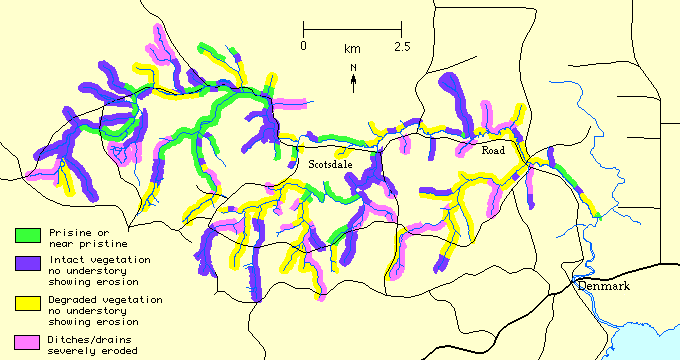
Foreshore condition and fencing status were assessed in detail along with fencing and rehabilitation needs and other information and the results were then collated.
In total, 68 kilometres of the Scotsdale Brook and its tributaries were surveyed. Of this, about 24% of the riparian zone was A grade, 26% B grade, 26% C grade and 24% D grade. Overall, 62 hectares of valley embankment and foreshore requires revegetation to stabilise the banks, and maintain both aquatic and terrestrial corridors. Of the total of 106 kilometres of watercourses in the Scotsdale Brook and its tributaries, approximately 41 kilometres of existing watercourse fencing is in place. Only 37% of surveyed foreshores were already fenced. A further 69 kilometres of fencing is recommended. 53% of the required fencing along the 20 kilometres of the Scotsdale Brook is in place.
The Scotsdale Brook catchment's waterways have many points of erosion and subsidence with the majors sections of degradation in its southern tributaries. Deposits of course sediments were observed frequently in the brook bed. Fencing has been placed along some of these sections, but in many cases at an insufficient distance from the waterway to provide an effective buffer.
The Scotsdale Brook catchment is intensively used for town water resources, small farms and residential development. In addition to protection, revegetation and weed management of the fringing vegetation of waterways it is recommended that all landusers:
For more information on river restoration techniques, the Department of Environment has a Water Note on the subject.