
|
Watching seagrass grow | June 2000 |
The health of seagrass within the Albany harbours is a major concern. Seagrass has a vital role in the aquatic ecosystem of the harbours, including providing stabilisation of the sea floor, shelter, feeding and breeding habitat for invertebrates and fish. With such a vital role in our aquatic ecosystem, any decline in seagrass health has an adverse effect on dependent species. This in turn can impact severely on our fishing and tourism industries.
Princess Royal Harbour and Oyster Harbour
Seagrass distribution and density has been monitored regularly in Princess Royal Harbour and Oyster Harbour over more than fifteen years. Surveys have been undertaken in response to a growing concern over the deterioration and contraction of seagrass meadows in the harbours. These surveys have been primarily based on evidence that nutrient pollution of the harbours results in enhanced macroalgal and epiphyte growth.This proliferation is linked to the decline in seagrass within the harbours generating concerns over the adverse effect this may have on the species dependent on the seagrass, including fish stocks.
Following the 1998 survey of seagrass density and distribution in King George Sound, a benchmark has been provided for subsequent studies to measure and monitor seagrass growth or decline. New surveys of seagrass undertaken in Princess Royal Harbour will be based on using community participation.
A new model for community participation in estuary monitoring has been established by the Department of Environment. This model will be used in future seagrass surveys within the Albany harbours. The Princess Royal Harbour survey monitoring has now been extended to incorporate the gathering of base line information for the Wellstead estuary. The new system will be used in the future to assess the impact of the end of algae harvesting in Princess Royal Harbour.
King George Sound
Initial surveys looked at the effect of industrial and rural discharges on seagrass health in Princess Royal and Oyster Harbours only. The 1998 survey of seagrass density and distribution in King George Sound now provides a benchmark for subsequent studies. Periodic monitoring will be necessary to measure seagrass growth or decline.
Innovative West Australian technology was used for this survey of the sound's 98 square kilometres. With water depths exceeding 25 metres in places, normal mapping techniques were inappropriate. Aerial surveys using video cameras mounted on a light plane, matched with fibre optics, provided remotely-sensed data (Digital Multi-Spectral Video or DMSV) to depths greater than 20 metres. This is the first time that DMSV technology has been combined with ground truthing in a seagrass survey. The technique has provided detailed information on seagrass type, condition, distribution, growth and decline at specific locations.
The information will assist with protecting our seagrass communities. It is of particular importance for providing effective management of the King George Sound marine environment, where pressure is increasing to expand aquaculture activities.
Seagrass transplanting has been carried out under the supervision of local marine scientist Geoff Bastyan. Trials with Posidonia species in Princess Royal and Oyster harbours have proven extremely encouraging, with the potential to rehabilitate areas that have suffered seagrass loss.
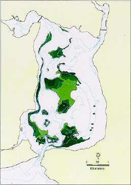
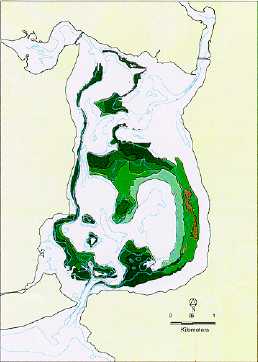
These maps of Oyster Harbour, showing the extent of seagrasses, illustrate the success of the seagrass tranplanting project over a period of eight years.
 |
 |
 |
| Seagrass distribution in Oyster Harbour in 1988 | Seagrass distribution in Oyster Harbour in 1996 |
 The success of these transplanting techniques has significant potential for large scale application and community involvement, not only in Albany but state and Australia-wide. So far, local volunteers have spent 110 hours on the project, which involves pegging, surveying, transplanting and growth measurements. Further work will involve more transplanting, measuring re-colonization rates and changes to seagrass distribution.
Another project has involved North Albany Senior High School students carrying out underwater surveys to map the density and distribution of seagrass at Little Grove. This will measure the impact of dredging and excavation for the new boat ramp on the coverage of adjacent seagrass beds.
This project was funded by Coastcare. For further information contact the Department of Environment.