|
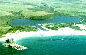
Taylor Inlet |
| Taylor Inlet at a glance | |||
| Catchment area: | 10 square kilometres |
||
| Average annual rainfall over catchment: | 850 - 900 millimetres | ||
| River length: | Two kilometres | ||
| Inlet size: | 50 hectares | ||
| Percentage cleared: | 70% | ||
| Data selection | |||
One small creeks drains the eastern and north-eastern foot of Mt Taylor-Mt Richard entering the inlet from the west, and two small creeks drain the lateritic sandplain to the north of the inlet entering the Inlet from the north. The total length of stream channels is about two kilometres.
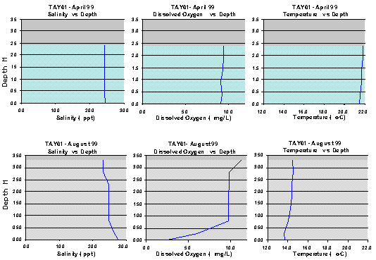
Profiles of salinity, dissolved oxygen, and temperature against water depth for Taylor Inlet site TAY01 for April and August 1999. Features to note are that in April the water column was well mixed as far as salinity and temperature were concerned with a slight decrease in dissolved oxygen at the bottom. In August however the water was slightly stratified with respect to salinity (and secondarily in respect of temperature) and consequently the dissolved oxygen was quite low at the bottom.
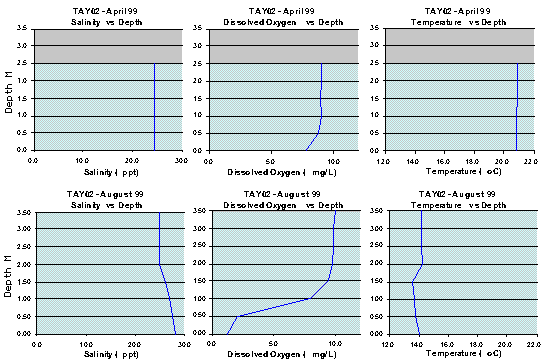
Profiles of salinity, dissolved oxygen, and temperature against water depth for Taylor Inlet site TAY02 for April and August 1999. Features to note are that in April the water column was well mixed as far as salinity and temperature were concerned with a slight decrease in dissolved oxygen at the bottom. In August however the water was slightly stratified with respect to salinity (and secondarily in respect of temperature) and consequently the dissolved oxygen was quite low at the bottom. Furthermore the water level had increased by about a metre between April and August and the temperature had fallen significantly.
Further Information:
South Coast Regional Land and Water Care Strategy: The Albany Hinterland Sub-region. Prepared by the South Coast Regional Assessment Panel and the South Coast Regional Initiative Planning Team: December 1996