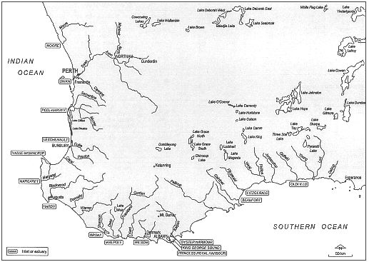
Figure 1-2: Waterways of south-western Western Australia
Waterways of south-western Western Australia
The waterways of south-western Western Australia are under constant pressure from human activities and are visibly showing signs of deterioration. Below is a comparison of the waterways of south-western Western Australia.
| Major Waterway | Tributaries | Area (km2) | Catchment Area (km2) | Average Rainfall in Catchment (mm) | Nutrient Status | Major Problems | Major Catchment Land Uses |
|---|---|---|---|---|---|---|---|
| Swan-Canning Estuarine System | 53.0 | 869 | Moderate | ||||
| Avon River | Moderate | Mainly dryland agriculture (wheat-sheep) |
|||||
| Peel-Harvey Estuarine System | 136.2 | 12,000 | 885 | Severely nutrient-enriched | |||
| Leschenault Estuary and Inlet | 25.4 | 4,933 | 871 | Moderate | Unknown | ||
| Vasse-Wonnerup Inlet | Unknown | Unknown | Unknown | Severely nutrient-enriched | Unknown | ||
| Hardy Inlet | 11.8 | 23,000 | 992 | Moderate | Increased saline drainage from cleared catchment | Unknown | |
| Donnelly River | 60 km long | 1,591 | Unknown | Nutrient poor | Unknown | Largely forested | |
| Warren River | 150 km long | 4,093 | Unknown | Nutrient poor | Unknown | Largely forested | |
| Gardner River | 35 km long | 539 | Unknown | Nutrient poor | Unknown | Largely forested | |
| Broke Inlet | 48 | 928 | Unknown | Nutrient poor | Unknown | Largely forested | |
| Walpole-Nornalup Inlet | 13.2 | 7,398 | 1,400 | Walpole: moderate Nornalup: nutrient poor | Walpole: nutrient enrichment; recreational pressures | ||
| Irwin Inlet | 10.0 | 2,270 | Unknown | Moderate | |||
| Parry Inlet | 1.4 | 119 | 980 | Moderate | As above | ||
| Wilson Inlet | 48.0 | 2,379 | 1,100 | Moderate | As above | ||
| Torbay | 1.0 | 399 | 880 | Severely nutrient-enriched | |||
| Oyster Harbour | 15.6 | 3,041 | 860 | Severely nutrient-enriched | Eutrophication resulting in excessive macroalgal growth and seagrass decline | Agriculture | |
| Princess Royal Harbour | 28 | 83.5 | 900 | Severely nutrient-enriched | Eutrophication resulting in excessive macroalgal growth and seagrass decline | ||
| Taylors Inlet | <1.0 | 10 | 800 | Moderate | Blue-green algal blooms | Unknown | |
| Normans Inlet | <0.5 | 18 | 850 | Unknown | Marginally fresh water | Unknown | |
| Waychinicup Inlet | 145 | 145 | 760 | Unknown | Marginally fresh water | Unknown | |
| Cheyne Inlet | Unknown | 77 | 610 | Moderate | Saltmarsh on northern side | Unknown | |
| Beaufort Inlet | 4.5 | 104 | 390 | Severely nutrient-enriched | Unknown | ||
| Wellstead | 2.5 | 716 | 510 | Unknown | Unknown | ||
| Gordon | Unknown | 1,770 | 405 | Unknown | Unknown | ||
| St Marys | Unknown | 169 | 490 | Unknown | Marginally fresh water | Unknown | |
| Fitzgerald | 7 | 1,611 | 410 | Unknown | Unknown | ||
| Dempster | 2.3 | 335 | 460 | Unknown | Marginally fresh water | Unknown | |
| Hamersley | 2.3 | 838 | 440 | Unknown | Brackish | Unknown | |
| Culham | West | 2,307 | 425 | Unknown | Unknown | Unknown | |
| Jerdacuttup | Unknown | 1,818 | 430 | Unknown | Unknown | ||
| Oldfield Estuary | 3 km long | 2,479 | 541 | Unknown | Apparently, good condition | Recent agricultural development | |
| Torradup River Estuary | 3.5 km long | 87 | 541 | Unknown | Unknown | Recent agricultural development | |
| Stokes Inlet | 14 | 4,575 | 541 | Unknown | Sedimentation | Recent agricultural development | |
| Barker Inlet | 1.8 | 259 | 541 | Unknown | Unknown | Recent agricultural development |