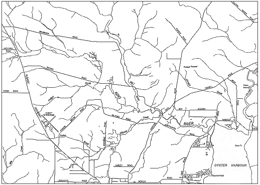
Figure 3-11: King River
King River
Figure 3-11: King River
The King River enters Oyster Harbour on its north-western corner. It drains a catchment, smaller than the Kalgan River's, to the north-west of the harbour. The river is about 27 kilometres long and is joined by a relatively large tributary, Mill Brook, two kilometres west of Upper King Bridge.
From Mill Brook to the Upper King Bridge the river has a narrow winding channel between high sandy banks. In the vicinity of the Upper King Bridge granite outcrops are found in, and near, the river. The river then flows through low-lying agricultural land with a fringe of sedges and paperbarks and then through a wide delta of saltmarsh and intertidal mudflats. It widens and deepens near the Lower Kalgan Bridge.
The river is estuarine for seven kilometres through low-lying land, most of which is cleared to the water's edge. Small boats can be launched into the King River at both the upper and lower bridges, but the river is very shallow above the lower bridge.
The King River is a more consistent input of fresh water to Oyster Harbour than the Kalgan River. This is mainly because the catchment is smaller and its rainfall higher and more reliable along the coast.
The foreshore areas of the King River are in public ownership in the downstream sections. However, in upstream areas the foreshore is still in private ownership. Land is owned right to the high water mark of the river. This means, for example, that it's hard for the public to walk along the river legally. It also means that it's the responsibility of the landowners to look after the fringing vegetation. The trees and other plants along the lower sections of the river are healthy and haven't been severely degraded by introduced species or other problems. However, the vegetation upstream becomes more and more degraded the further along, with more weeds and frequent fires.