
|
Angove Creek |
| Angove Creek at a glance | |||
| Catchment area: | 29 square kilometres | ||
| Average annual rainfall over catchment: | 850 millimetres | ||
| River length: | 11 kilometres | ||
| Annual discharge volume into Angove Lake: | 1,880 Megalitres | ||
| Percentage cleared: | 5% | ||
| River health: | fresh | ||
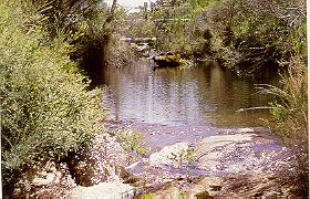
The Angove catchment is located within the large bush block of Water Reserve 13802 and a small amount in the nature reserve. Only 5% of the catchment is cleared, mainly on the upper reaches and about the lake. Nevertheless both the stream system and the lake within the reserve are in a highly natural state. Lake Angove itself is a relatively large sedge swamp, supporting large stands of the tall sedge Baumea articulata, which thins out and gives way to open waters of the deeper central parts of the lake. The extensive sedge swamps are important habitat for the uncommon and secretive Australian Bittern. Surrounding the lake are fringing forests of paperbark and Agonis.
The lake systems are joined by natural creek and an artificial drainage line. Moates Lake overflows into Lake Gardner which in turn overflows into the ocean via a natural creek. The creek below Gardner was once connected to Angove via a swampy area, but today this area is cleared and a drain has been dug from Agove to the creek, presumably to reduce flooding from the lake and waterlogging of the farmland . It is likely that this drain has reduced water levels in Angove Lake and enabled fringing vegetation to encroach upon the lake. Observations of the lake in October 1998 did not provide any clear evidence that this has occurred, but lack of dead and dying fringing vegetation certainly suggests that the opposite had not occurred.
Further Information:
South Coast Regional Land and Water Care Strategy: The Albany Hinterland Sub-region. Prepared by: the South Coast Regional Assessment Panel and the South Coast Regional Initiative Planning Team December 1996.

