
|
Albany Eastern hinterland catchment |
| Overview | 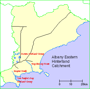 |
Waterways |
The Albany Eastern Hinterland catchment comprises the area around the Sisters Wetland Group and Two People's Bay Wetland Group, together with the catchments of Waychinicup River and Angove Creek, along with their tributaries plus some the small creeks, drains and land which drains to the wetlands.
Climate
Rainfall varies over the area, averaging from nearly 900 millimetres on the south coast to around 650 mm in the north-east. About two-thirds of the annual rain falls in the six months from May to October. Seasonal rainfall and potential evaporation dictate the length of the growing season, which varies between seven and ten months in the sub-region.
Soils and landforms
Most of the area is underlain by the Albany-Frazer Orogen, which is composed of gneissic and granitic rocks of Proterozoic age. Much of the soil has poor drainage, with rain-borne salt accumulating in deep soil profiles. Rising groundwater levels caused by the clearing of native vegetation has mobilised these salts.
Flora and fauna
The area is home to mallees and the rich heaths of the sand plains.
The Waychinicup area is recognised as an area of species richness. The area is also notable as a habitat for a number of threatened fauna. Dibbler, Southern Brown Bandicoot, Western Ringtail Possum, Gilberts Potoroo, Quokka, Western Bristle Bird, Western Ground Parrot, Carnabys Cockatoo, Western Whipbird and the Noisy Scrub Bird can all be found in the area.
Land use
The Albany district was first settled in the early 1800s, and became the centre for large pastoral holdings. As people spread out from the port, and with Government incentives to agriculture resulted in widespread settlement of the catchment by the mid 1800s, and the latter part of that century saw diverse farming and agriculture in the area.
More recently, sheep and cereal have become major land uses.
Wetlands Surveys
The following wetlands in the catchment have been surveyed and "report cards" prepared. The reports are available as PDF files. The locations of the wetlands can be seen on the survey map and in the overall survey report.
