|
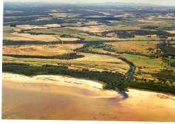
Sleeman-Cuppup Rivers |
| Sleeman-Cuppup Rivers at a glance | |||
| Catchment area: | 98 square kilometres |
||
| Average annual rainfall over catchment: | 890 millimetres | ||
| River length: | 22 kilometres | ||
| Annual discharge volume into Wilson Inlet: | 13,500 Megalitres | ||
| Percentage cleared: | 77% | ||
| River health: | slightly saline | ||
The Sleeman River was surveyed in 1998 to assess the condition of the foreshores in the Catchment, with particular emphasis on drains. In total 23.8 kilometres of the Sleeman River was surveyed. Of this length, only 9% of the riparian zone was pristine to slightly disturbed, 44% was degraded, 16% was erosion prone to eroded and 31% was an eroding ditch or weed infested drain. 28.3 kilometres of fencing was already in place protecting the Sleeman River foreshores, representing 60% of the total fencing required and recommended. Overall, about 11 hectares of river valley embankments and foreshore requires revegetation, divided between three main localities.
Monitoring for nutrients in the catchment of the Wilson Inlet has indicated that Cuppup Creek, Little River, Sleeman River and Sunny Glen Creek appear to be enriched with nutrients to some extent. The Sleeman River and Little River have slightly elevated nitrogen concentrations with median levels between 1.0 and 1.5 mg/litre. Little and Sleeman rivers each had median phosphorus concentrations of 0.12 mg/litre. Guidelines recommended by ANZECC suggest that 0.75 mg/litre of nitrogen and 0.1 mg/litre of phosphorus are acceptable concentration limits in streams.
Extensive clearing along the main channel has reduced the Sleeman to not much more than an agricultural drain. It has been straightened and channeled in sections, and is periodically cleaned out.
The Sleeman-Cuppup is a major source of nutrients responsible for polluting Wilson Inlet.
In 2005 a project (Our Living Rivers) was set up to collect and analyse data, enabling the Department of Water to monitor the health of the river over time and help determine what systems need better protection. In spring 2006 and 2007 samples were taken from the river system to assess the quality of the water and habitat as well as the presence of fish and macroinvertebrates. Two sites were sampled in the Sleeman River system.
Further Information:
South Coast Regional Land and Water Care Strategy: The Albany Hinterland Sub-region. Prepared by: the South Coast Regional Assessment Panel and the South Coast Regional Initiative Planning Team: December 1996