 |
Denmark catchment |
| Overview |  |
Waterways |
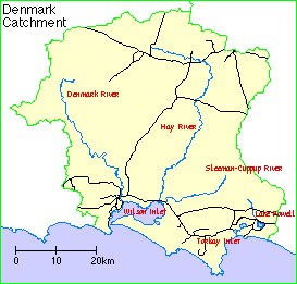
The Denmark catchment comprises Wilson Inlet, Torbay Inlet and Lake Powell together with the catchments of the Denmark, Hay and Sleeman-Cuppup Rivers and their tributaries, plus the small creeks and drains and the land from which water flows into the inlets.
Climate
This is a high rainfall area, averaging over 1200 millimetres on the south coast. Inland, the average annual rainfall decreases to around 700-800 mm. About two-thirds of the annual rain falls in the six months from May to October. Seasonal rainfall and potential evaporation dictate the length of the growing season, which varies between seven and ten months in the sub-region.
Soils and landforms
Most of the area is underlain by the Albany-Frazer Orogen, which is composed of gneissic and granitic rocks of Proterozoic age. Much of the soil has poor drainage, with rain-borne salt accumulating in deep soil profiles. Rising groundwater levels caused by the clearing of native vegetation has mobilised these salts.
There are a mixture of soil types in the catchment:
Many of the soils have been formed on highly weathered parts of the laterite profile, and are very infertile. Trace elements have to be added to lateritic soils, and nitrogen has been applied both as a fertiliser and by growing of legumes. Leaching of the soils in the high rainfall areas has resulted in their becoming acidic.
Flora
The flora of the region is a rich and varied jarrah and karri forest.
Land use
The area first settled in the early 1800s, initially as large pastoral holdings. The discovery of gold in the area and Government incentives to agriculture resulted in widespread settlement of the catchment by the mid 1800s, and the latter part of that century saw diverse farming and agriculture in the area.
In the early 1900s there was increased timber milling. The area developed potatoes, dairying, pigs and beef cattle, with wool, sheep and fat lambs. More recently, cereal crops have become a major feature, and the area has growing wine and tree-cropping industries.
The town of Denmark is in the catchment.
Wetlands Surveys
The following wetlands in the catchment have been surveyed and "report cards" prepared. The reports are available as PDF files. The locations of the wetlands can be seen on the survey map and in the overall survey report.
Management Reports
Management recommendations:
in Parry Inlet's Waterways. A Snap-shot of the Condition of Stream Foreshores in the Parry Inlet Catchment, Shire of Denmark (1999) Greenskills
in Survey and Management Recommendations for the Foreshores of the Five Mile and Seven Mile Creeks, Torbay Catchment (2000) Greenskills
in Foreshore condition survey and management recommendations for drains and waterways in the Torbay Inlet sub-catchment (2003)
in Marbellup Sub-catchment Foreshore Condition Survey (2001) Water and Rivers Commission
in Waterways - Upper Denmark Catchment and Springs Catchment (Upper Hay River) (2004) Greenskills
and The condition of the Denmark and Hay River Foreshores. Report No 60 (1995) Waterways Commssion
in Survey of Waterways: Hay and Sleeman River Catchments (2007) Greenskills
and Survey and Management Recommendations for Foreshores of the Sleeman River and Cuppup Creek Catchments (1999) Greenskills, Luke Pen
in Survey and Management Recommendations for Foreshores of the Sleeman River and Cuppup Creek Catchments (1999) Greenskills, Luke Pen
Foreshore survey:
in Survey of Stream Foreshores in the Scotsdale Brook Catchment Denmark, W.A. WRT 19 (1998) Water and Rivers Commission
Copies of these reports are available from the Albany office of the Department of Water.