|
Coobidge Creek |
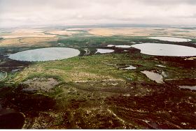
There is a chain of wetlands associated with the mid-upper section of Coobidge Creek contained within a large block of remnant vegetation. This chain of salt lakes appears to have formed in a diagonal line WNW-ESE and is possibly the remnant of a sediment filled ancient watercourse. The Coobidge Creek catchment draining into the wetland system is approximately 20700 hectares. Almost 20000 hectares of this area is cleared farmland, leaving less than 5% of the catchment with remnant vegetation. Annual rainfall is approximately 620mm at Esperance, with 410mm at Scaddan, 50km to the north.
In 2005 a project (Our Living Rivers) was set up to collect and analyse data, enabling the Department of Water to monitor the health of the waterways over time and help determine what systems need better protection. In spring 2006 and 2007 samples were taken from the creek to assess the quality of the water and habitat as well as the presence of fish and macroinvertebrates. Two sites were sampled on Coobidge Creek.
Further Information:
South Coast Regional Land and Water Care Strategy: The Esperance-Sandplain Sub-region. Prepared by: the South Coast Regional Assessment Panel and the South Coast Regional Initiative Planning Team, February 1997.