
|
Esperance catchment |
| Overview | 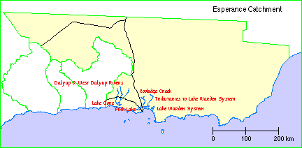 |
Waterways |
The Esperance catchment comprises Lake Gore, Pink Lake, and the Lake Warden System together with the catchments of Coobidge Creek and the Dalyup and West Dalyup Rivers and their tributaries plus the small creeks, drains and land which drains to these wetlands, and the associated lakes.There are also a number of small creeks and rivers east of Esperance.
Climate
The area is comparatively dry, with rainfall averaging from around 600mm on the coast to 400mm inland. About two-thirds of the annual rainfall falls in the six months between May and October. This means there is significant summer rain in many years.
Soils and landforms
Many of the soils in the sub-region have formed on leached sandy soils and therefore are very infertile. Leaching of some sandy soils have resulted in them becoming acidic.
Flora
Scrub heath and mallee heath occur on the sandplain, with Banksias, Chittick and Tallerack being characteristic species. Eucalyptus mallee occupies valleys incised into the plain.
Coastal dunes support typical coastal low scrub. Inland there is a flat swampy sandy plain dominated by Banksia, with some Eucalyptus. Melaleuca is prevalent in swamps.
Land use
The area was first used as grazing land in the mid to late 1800's, but the development of Esperance as a harbour in the late 1800's that saw the significant growth of the town as a regional centre.
The region lessened in importance at the turn of the 19th century, but a boom in grain production in the mid 1920's resulted in the major land use being made over to farming. Farming is still the main industry, and is expected to remain so.
Wetlands Surveys
The following wetlands in the catchment have been surveyed and "report cards" prepared. The reports are available as PDF files. The locations of the wetlands can be seen on the survey map and in the overall survey report.
Management Reports
Management recommendations:
in Recommendations for the Management of the Lake Gore and Coobidge Creek Wetlands (2001) Greenskills
in Dalyup and West Dalyup Rivers Action Plan (2000) Water and Rivers Commission
Foreshore survey:
in The Many Faces of Bandy Creek - An assessment of conditions and values (main channel) (2006) Andy Chapman
Copies of these reports are available from the Albany office of the Department of Water.
