|
Waterways east of Esperance |
|
|
|
|
|
|
Immediately east of Esperance, Bandy creek was an estuary until the small boat harbour was constructed in 1982 and a dam wall built prevented sea water entering it.
Eastwards to Cape Le Grand a series of creeks drain through the wide belt of Quaternary dune sand behind the long high energy west facing beach.
East of Cape Le Grand the land rises steeply from the coast to the sandplain of the plateau at about 80 metres above sea level. Here the creeks and rivers have cut narrow valleys in the soft spongolite (Pallinup Siltstone) rock that borders the coast and overlies the harder granite bedrock.
Between Cape Le Grand and Duke of Orleans Bay the creeks are short and probably only hold water following winter rains.
East from the Duke of Orleans Bay there are again many short creeks, but here several rivers have excavated deep valleys in the spongolite rock and discharge to narrow riverine estuaries one to two kilometres long. The heads of the creeks are only about ten kilometres from the coast on the edge of the plateau. These are: Dailey River, Mungliginup Creek, Alexander River, Blackboy Creek and Thomas River. The estuaries are all (or shortly will be vested) within reserves; the first four in small reserves managed by the Shire and Thomas river in Cape Arid National Park. Other vacant Crown land from Mungliginup Creek to Cape Arid National Park will be incorporated in a proposed Nature Reserve. The estuaries are in uncleared coastal bush but the tributaries extend into cleared farmland on the plateau though the deep tributary gullies are still largely uncleared. Small dams have been constructed in a number of them. Most of the clearing was done in the late 1950s and 1960s.
Further east in the Cape Arid National Park, creeks have carved valleys in the granite. Two of these discharge in to small estuaries on the eastern shore of the peninsula: Jorndee Creek and Poison Creek (names that appear on few maps).
Small though these seven estuaries are of considerable interest, and there should be further study of them. They differ from most estuaries further west being in narrow valleys cut deep through the spongolite and dune sand or, at Cape Arid, in granite. They differ from most estuaries further west being in narrow valleys cut through spongolite and dune sands, at Cape Arid, in granite. In form they resemble the riverine estuaries of the Donnelly, Warren and Gairdner Rivers, but hydrologically and biologically they are totally different. In contrast to the mainly fresh water of the three western estuaries the water is brackish to more salt than the sea.
In 2005 a project (Our Living Rivers) was set up to collect and analyse data, enabling the Department of Water to monitor the health of the south coast rivers over time and help determine what systems need better protection. In spring 2006 and 2007 samples were taken from the river systems to assess the quality of the water and habitat as well as the presence of fish and macroinvertebrates. Bandy Creek and the Dailey and Thomas Rivers were sampled as part of this project.
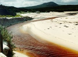
This creek is no longer estuarine, having been dammed close to the mouth to make the small boat harbour. However before 1982 it was estuarine for perhaps three kilometres, winding in a channel less than ten metres wide between steep banks through the coastal sand dunes. It widened to about 200 metres at the mouth and was closed by the beach, here 100 metres wide and of fine white sand. The beach was low and waves washed over into the estuary. In 2007 the weir that dammed the river was washed away and discussions commenced (2008) about the future reinstatement of the weir.
Two sites were sampled on Bandy Creek as part of the "Our Living Rivers" project.
Salinities recorded in the estuary:
| 12/04/1971 | 11.5 ppt |
| 03/05/1977 | 30 ppt |
The northern part of the estuary lies between the high, densely vegetated foredune and rising land with low coastal shrub. The dune narrows southwards and becomes little more than a beach ridge with scattered vegetation, and on the landward side the estuary is separated from a small swamp by dune. Rushes (Juncus) and paperback trees (Melaleuca) fringe part of the estuary and windclipped Banksia speciosa is dense along the dunes.
The estuary is seven to ten metres wide and two metres deep. It discharges across the beach at the end of the tombolo which connects Table Island to the shore. It is reported to break through the beach frequently. The sparsity of vegetation along the southern part of the shore dune suggests that estuary water may break through further north during floods. The beach faces east and the mouth on is in the shelter of the Table Island and the tombolo and by Mount Belches.
Salinity of estuary water was from eight ppt to ten ppt near the mouth on 4 May 1977. The presence of shells of the small gastropod Coxiella sp. suggests that the water is sometimes hypersaline. Much decaying seagrass is washed across the beach into the estuary, probably providing a rich food source for the fauna. Fishing is reported to be good in the estuary.
Access to the estuary is from Orleans Bay Road off Merivale Road 65 kilometres east of Esperance. The road continues to Duke of Orleans Bay where there is a caravan park, general store and camping area at Wharton townsite in the shelter of Mount Belches. The Duke of Orleans Regional Reserve extends from the Cape Le Grand National Park to Mungliginup Creek.
Three sites were sampled on the Dailey River and Duke Creek system as part of the "Our Living Rivers" project.
The mouth is within 500 metres of the western end of the four kilometre long, south facing Membinup Beach and is sheltered from the south westerly winds and swell by the rocky headland of Membinup Point. The estuary opens onto a 200 metre wide beach of fine whit silica sand across which it may flow in a flood. But from that position it cuts shallow channel eastwards behind the beach and against the dunes for about 300 metres, at which point it is closed by beach sand.
The estuary always holds water but the bar is reported to break infrequently - at intervals of several years. When visited on 6 May 1977 the bar was closed and the salinity of the water was 46 ppt at the mouth and 42 ppt 1.2 kilometres up the estuary. River water is always salty and flowing water is a tributary creek had a salinity of 26 ppt. Ruppia and the alga Polyphysa were growing in the estuary and the small bivalve mollusc Spisula trigonella was abundant.
Access to the estuary is from Daniels Rd off Merivale Road, 77 kilometres east of Esperance, thence by a bush track to the beach at Membinup Point.
The valley widens near the coast. Rushes, samphire and dense paperbark scrub border the estuary, which is only ten metres wide. The estuary opens into the deep curve of Alexander Bay, three kilometres from thee western rocky headland. The headland and Ben Island give it limited shelter from the south west winds and swell. The fine silica sand of the beach fills the mouth of the estuary, which is set back 200m from the line of the otherwise narrow beach.
The salinity of the water was measured on the 6 May 1977 where it was 26 ppt. It was tannin stained with some evidence of sediment. There were floating mats of blue-green algae.
Access is to the western side of the estuary from Alexander Road off Merivale Road, 85 kilometres from Esperance, thence for four kilometres of eroded bush track to the beach and behind the dunes or along the beach to the mouth.
Access is by a bush track from Exchange Road off Merivale Road, 93 kilometres east of Esperance. This leads to a rock outcrop on the beach 1.5 kilometres west of the mouth.
The estuary is narrow (20 metres) and shallow near the mouth where sand falls into it from a small blowout on the eastern bank. It then widens to about 20 metres for 500 metres before narrowing to 10 metres or less. A small tributary creek flows into the estuary from behind the western dunes near the mouth.
In October 1971 a salinity of 22.5 ppt was recorded and in 1977 26 ppt.
The estuary is in the Cape Arid National Park, with a small Shire Reserve on the west bank of the river. Access to the estuary and to the Park Ranger's residence is by Tagon Road from Merivale Road, 105 kilometres east of Esperance.
One site was sampled on the Thomas River as part of the "Our Living Rivers" project.
The estuary is 500 metres long and five to seven metres wide between steep banks with a dense cover of paperbarks and banksia (Banksia speciosa), which block the channel at the head. It widens to about 50 metres near the mouth with rushes and samphire along the shore and a wide flat with Suaeda.
Water in the estuary was of seawater salinity when visited on 5 May 1977 and on 14 April 1971; this is presumably the normal situation except where the creek is flowing.
The estuary is in the Cape Arid National Park. Access is by a bush track (two kilometres) off Poison Creek Road.
The estuary is 700 metres long, about 15 metres wide and shallow near the mouth. Dense paperbark thickets clothed the banks near the mouth, but these have been badly degraded by the campers. This area has now been closed and will be rehabilitated.
The estuary is in the Cape Arid National Park. Access is by Baring Road and Poison Creek Road off Fisheries Road.