|
Irwin Inlet |
| Irwin Inlet at a glance | ||||
| Inlet area: | 10 square kilometres | |||
| Data selection | ||||
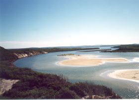
The inlet is at an advanced stage of sediment loading. It is very shallow, and is gradually turning into swampland. However, the main basin still supports extensive seagrass beds and is still used for commercial fisheries.
In 2005 a project (Our Living Rivers) was set up to collect and analyse data, enabling the Department of Water to monitor the health of the river over time and help determine what systems need better protection. In spring 2006 and 2007 samples were taken from the Bow River to assess the quality of the water and habitat as well as the presence of fish and macroinvertebrates. Two sites were sampled on the Bow River system.
Further Information:
South Coast Regional Land and Water Care Strategy: The Kent-Frankland Sub-Region. Prepared by: the South Coast Regional Assessment Panel and the South Coast Regional Initiative Planning Team: December 1996