
|
Kent catchment |
| Overview | 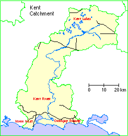 |
Waterways |
The Kent catchment comprises Irwin Inlet and Kent Lakes together with the catchment of the Kent River and its tributaries plus some of the small creeks, drains and land which drains to the inlet. Most of the information here relates to a more restricted site, comprising the lower reaches of the Kent River and Owingup Swamp; also the three "Boat Harbour" lakes (1.5 kilometres south-east) and several small swamps nearby.
Physical features
Landform: Microscale (width) irregular-sinuous river (Kent River) entering a macroscale irregular lake (Owingup Swamp) through a well-developed delta; also microscale-mesoscale irregular-elongate lakes (Boat Harbour Lakes), and microscale-mesoscale irregular sumplands (other swamps).
Most of the sub-region is underlain by the Yilgarn Craton which is composed of granitic and gneissic rocks of Archaean age, similar to that under the wheatbelt. The southern section is underlain by the Albany-Fraser Orogen. An east-west series of dolerite dykes has intruded into the Archaean rocks to the north of the contact with the Albany-Fraser Orogen.
Poor drainage in the upper Kent River area has resulted in rain-borne salt accumulating in deep soil profiles. Clearing of native vegetation has caused groundwater levels to rise and mobilise these salts.
The Kent catchment overlies an area that is gently undulating and poorly drained with numerous large swamps. Soils are shallow leached sands over rock or laterite.
The most common land in the upper Kent catchment is severely waterlogged footslopes and flats (25%) followed by gravel slopes and remnant bush (each 20%), streams and wetlands (8%), deep sands and red soils (each 5%) and rock outcrops (2%). The gravel slopes are the main cropping soils. These grade into the waterlogged footslopes, the transition being dependent on seasonal rainfall. The deep sands include lunettes near lakes, while the red soils include karri loams.
Many soils have a duplex or texture contract profile - a sandy gravel topsoil over a clayey subsoil which may be alkaline in the valleys and acidic on hilltops.
Geological setting: The system is situated in the Albany-Fraser Orogen (gneiss), in lowland between the undulating interior (to 80 metres) and coastal dune range (to 120 metres). At Owingup Swamp the lake bed is sandy under open water and muddy under sedgeland; "algae biscuits", an uncommon formation related to stromatolites, occur in the north-east. At Boat Harbour Lake A, the bed is obscured by organic gelatinous suspension more than one metre deep; the suspension comprises diatoms, blue-green algae, invertebrates and their faecal pellets, held together by mucopolysaccharide gel excreted by the unicellular algae. Boat Harbour Lakes B and C have sandy beds and the suspension described for Lake A is also extensive in parts of Lake B.
Climate: Median and mean annual rainfall at Denmark are 1094 millimetres and 1108 mm respectively, mostly falling in April-September; annual evaporation is about 1200 mm.
The average annual rainfall varies from around 500 mm in the northern part of the catchment to above 1200 mm in the south west coast. About two-thirds of the annual rain falls in the six months between May and October. Potential evaporation in the area is less than the annual rainfall in the south west, but is much higher than the annual rainfall in the north east. Seasonal rainfall and potential evaporation dictate the length of the growing season, which varies between 6 and 10 months in the sub-region.
With its more uniform rainfall, fewer hot winds, high cloud cover and low frost risk, the south coast has a relatively long growing season, and some crops may be grown with a lower annual rainfall than is possible near the west coast.
Hydrological features
Hydrological Role: Owingup Swamp probably has a role in reducing flooding nutrient loading and siltation in downstream parts of Kent River.
Water supply: Kent River originates 85 kilometres north north-east in land that is mostly cleared, though much of the lower catchment is forested. It enters the north-west of Owingup Swamp and reappears two kilometres west south-west, beyond the wooded forest (no clearly-defined connecting channel known), to flow west into Irwin Inlet. A creek originating seven kilometres north north-east probably contributes some inflow. Other wetlands (notably Boat Harbour Lake B) probably are surface expressions of groundwater; outflow occurs from Lake C to Lake A and apparently also from Lake B to Lake A, and drains from cleared land enter Lake C.
Inundation: The small marshes are seasonal, other wetlands permanent, though Boat Harbour Lakes B and C show sandy beaches in summer and Lakes A-C may dry out occasionally. Owingup Swamp extends into fringing scrub and wetland forest in winter-spring but is confined to the main (inner) basin in the dry season.
Water depth: Owingup Swamp: 2.1 metres in July, 0.7 metres in April; Boat Harbour Lakes: 1.2-1.5 metres in August, 0.35-0.85 metres in April. Occurrence of large stumps of dead trees in the bed of Boat Harbour Lake C indicates shallower water there in the past.
Water salinity: The limited data indicate that all wetlands are fresh in winter-spring (e.g. Owingup Swamp, 0.17 ppt; Boat Harbour Lake B, 0.87 ppt) but Owingup Swamp and Boat Harbour Lakes A and B are brackish in summer-autumn (up to 1.80, 1.10 and 2.11 ppt respectively).
Water pH: Owingup Swamp: 6.1-7.4; Boat Harbour Lakes: 7.4-8.1.
Water colour: Brown at Owingup Swamp, none at Boat Harbour.
Ecological features
Ecological role: The site supports a significant number of Australasian Bittern Botaurus poiciloptilus (possibly also breeding), being one of only five "centres of population" for the species in Western Australia. It also appears to be a major nursery area for freshwater and estuarine fishes.
Plant structural formations: Owingup Swamp and Boat Harbour Lake C support closed-heathland, closed-scrub, low closed-forest and sedgeland in heteroform arrangement; Boat Harbour Lakes A and B support closed-scrub and closed-sedgeland in zoniform arrangement; smaller swamps support closed-scrub and closed-sedgeland in maculiform arrangement. Surrounding areas support open-scrub and low open-forest to open-forest.
Significance
A good example of a system of permanent freshwater lakes and marshes, exhibiting several features that are uncommon in south-western Australia: a well-developed lake delta and an outflow river (at Owingup Swamp), and extensive areas of organic gelatinous suspension (Boat Harbour Lakes).
Notable flora:
Threatened species: None.Composition: 53 plant species (five of them exotic) recorded in the wetland at Owingup Swamp, 16 at Boat Harbour Lake A, 18 at Boat Harbour Lake B and 43 at Boat Harbour Lake C. The lakes each support six to 12 sedge species; usually Baumea articulata is dominant, but Gahnia trifida is dominant at Boat Harbour Lake A, and Typha orientalis (mainly at Boat Harbour Lake B) and B. vaginalis and B. arthrophylla (Owingup Swamp) occur in substantial area. Baumea is the dominant genus in the system, with seven species present. The wetland forest is of Agonis juniperina. Scrub/heath formations comprise eight to 12 species at each lake, the most conspicuous being Callistachys lanceolatum, Beaufortia sparsa, Banksia littoralis, Melaleuca spp., Agonis linearifolia and Astartea fascicularis. Owingup Swamp supports nine aquatics (e.g. Potamogeton drummondii), and eight annuals on the drying lake-bed, e.g. Cotula coronopifolia.
Special Communities: Owingup Swamp supports the largest remaining area of mature Agonis juniperina forest, covering several hundred hectares.
General comments: Jarrah low forest predominates normally, with little marri present. On patches of better soil the cover improves to jarrah-marri forest. Swamps occur as narrow shrub along drainage lines or as larger areas occupying broad valley floors. Reeds and heath shrubs line the drainage lines, and scattered reeds and paper barks occur in the broad valleys.
Notable fauna (waterbirds):
Threatened species: The Australasian Bittern occurs, probably regularly, in sedgeland at Owingup Swamp (up to five, January 1992, regional rank 2) and Boat Harbour Lake A (3, November 1984); habitat appears suitable for breeding.Composition: 45 species recorded in the system, nine listed under treaties; 40 recorded at Owingup Swamp. The 45 include five darters and cormorants, seven herons and allies, nine ducks and allies and ten shorebirds. Seven Long-toed Stint Calidris subminuta were at Owingup Swamp in January 1988.
Breeding: Ten species found breeding, mainly at Owingup Swamp; all probably breed regularly. The ten include the Darter and the Little Black Cormorant (both along Kent River), Spotless Crake and the Blue-billed Duck.
Moulting: Small numbers of swans and ducks have been found moulting at Owingup Swamp in early summer.
Migration Stop-over: Six migrant shorebirds recorded, only Red-necked Stint in appreciable numbers (200, Boat Harbour Lake A).
Roosting: At Owingup Swamp, flocks of up to 80 Australian White Ibis roost in Agonis forest, and ducks and up to 48 Yellow-billed Spoonbill roost on granite rocks.
Numbers: The highest number of waterbirds counted was 1457 at Owingup Swamp in March 1991. Probably more than 1000 waterbirds use the system annually. The most abundant species are Eurasian Coot (1200) and Australian Shelduck (492), both at Owingup Swamp.
Notable fauna (other taxa):
Threatened species: None.Composition: Nine fish species recorded in the system; eight at Owingup Swamp, five at Boat Harbour Lakes A and C, nil at Boat Harbour Lake B. The nine include three secondary species including Afurcagobius suppositus at Owingup Swamp, which is estuary-connected. The system supports two fishes that are endemic to the far south coast of WA: Balston's Pygmy Perch Nannatherina balstoni (Owingup Swamp, Boat Harbour Lake A) and Black-stripe Minnow Galaxiella nigrostriata (Owingup Swamp). Common Jollytail Galaxias maculatus has been recorded at Boat Harbour Lake C; in WA it otherwise occurs east of Albany, in ocean-connected waters. The system is relatively rich in macroinvertebrates: 45 taxa, including 14 Diptera, are known from Owingup Swamp; 72 taxa, including 27 Diptera, are known from Boat Harbour Lakes A and C. Crustaceans present include Koonac, Gilgie, the exotic yabbie and the shrimp Palaemonetes australis. Tortoises also are present.
Breeding: Owingup Swamp is apparently a nursery area for secondary fishes, notably Atherinosoma wallacei.
Social and cultural values:
Research: By RAOU/WADCALM (19 waterbird/waterfowl surveys, 1981-91), WADCALM and consultants (surveys of flora, invertebrates and water chemistry, 1991-2).Aesthetics: The juxtaposition of lake waters, extensive sedgeland, undisturbed cedar forest and (in the background) high, vegetated coastal dunes, presents an attractive natural landscape. Undisturbed, karri-lined reaches of the Kent River are especially scenic.
Land tenure and land use
Land tenure
On site: Apart from the far north north-west of Owingup Swamp, entirely in Nature Reserves 41010 (all basins) and 20381 (upper part of the river).Surrounding area: Nature reserves and freehold.
Current land use :
On site: Nature conservation and recreation.Surrounding area: Nature conservation, pasture grazing, recreation and low human population. Most of the wetland has a buffer of native vegetation more than 1 kilometre wide, except the north of Owingup Swamp and upper parts of the river (buffer less than 100 metres).
The area is dominated by farming and grazing properties, with some forestry industry. There is a trend towards fewer, larger farms in the broad-acre areas and increasing numbers of small holdings in the south coastal area, due to sub-division and more intensive agriculture.
Original settlement was by men with large pastoral holdings, predominantly grazing sheep. In the mid-1800's government incentives to encourage farming and the discovery of gold gave a tremendous boost to the population. Settlers followed the pastoralists where grass and water were available. Orchards were established and cows introduced.
During the 20th century settlement of the area was well established, with large-scale land clearing and towns established. Much of the land has been alienated and cleared. That land which is still under remnant vegetation exists mainly as substantial blocks or corridors.
Conservation
Current threats: At Owingup Swamp: Salinisation, eutrophication and siltation from inflow of Kent River. At Boat Harbour Lakes B and C: Recreation (horse-riding on wetland beaches)
Potential threats: At Owingup Swamp: Too frequent wildfires (a major threat to the large Agonis juniperina forest), exotic fishes.
Research: A research project focussing on the Kent Catchment has been undertaken by the Land and Water Resources Research and Development Corporation under the National Dryland Salinity Program.
Management authority and jurisdiction: Reserves are managed by WADCALM for NPNCA. Their district office is located at Albany.
Wetlands Surveys
The following wetlands in the catchment have been surveyed and "report cards" prepared. The reports are available as PDF files. The locations of the wetlands can be seen on the survey map and in the overall survey report.
Management Reports
Management recommendations:
in Survey and Management Recommendations for Foreshores of the Upper Kent River (1998) Greenskills, Like Pen
Foreshore survey:
in Catchment West of the Irwin Inlet (2003) Greenskills
Copies of these reports are available from the Albany office of the Department of Water.
