|
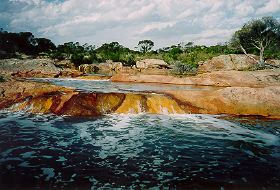
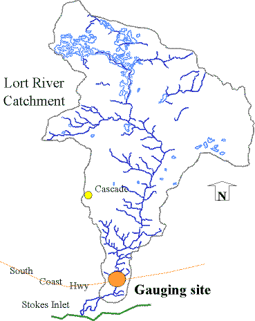
Lort River |
| Lort River at a glance | |||
| Catchment area: | 2502 square kilometres |
||
| Average annual catchment rainfall: | 360 millimetres | ||
| River length: | 130 kilometres | ||
| Annual discharge into Stokes Inlet: | 6190 Megalitres | ||
| Percentage cleared: | 60% | ||
| River health: | highly saline | ||
|
|
|
|
|
|
The Lort starts about 110 kilometres north of the coast on the Yilgarn plateau. In this Mallee Region, the landscape is gently undulating, the rainfall is about 350 mm per annum and the soils are saline loams and sand over clay. Towards the coast, the terrain is more dissected as the rivers descend through siltstone to the coastal plain and where the annual rainfall is about 550 mm per annum. Most of the Lort River catchment is located within the mallee sub-region. Most of the lower 60 kilometres of the river, which is on the Esperance sandplain, lies within a naturally vegetated corridor.
Much of the lower parts of the catchments and 60% of the Lort River catchment has been cleared since the late1950s.
River flow is highly variable and dry years may be negligible. Some permanent river pools are maintained by springs. River degradation, especially the loss of riparian vegetation, sedimentation and eutrophication of river pools has resulted from clearing.
The Lort River is naturally saline, rising in the salt lake country to the north, and there are salt lakes in the upper part of the Lort catchment. Salinity levels are thought to be elevated through extensive clearing in the catchments, which has also caused an increased amount of sediment to be washed from the highly erosive sandy soils, filling river pools and clogging channels.
Geology of the rivers
(information taken from Leighton and Watson, 1992)
The Young and Lort River's headwaters straddle the geological boundary between the Yilgarn block and the younger Albany Fraser Province. The catchment creeks flow over sand and gravel plains, overlying granite rocks. The river then flows through metamorphosed granites and gneiss, and in parts carves a channel though the bedrock forming steep sided valleys 30-45 metres deep. Towards the coast, the river flows through sediment deposits before assuming youthful characteristics where it cuts through Eocene rocks (Thom, Lipple, Sanders, 1977).
Vegetation
The river was mapped and described in a broad scale by J.S Beard as part of the Vegetation Survey of Western Australia. Beard differentiated two vegetation formations along the rivers including Shrublands and Low forest. The lower reaches of the Young and Lort River have been identified as being within the Esperance system of plant communities. The vegetation of this is mallee-heath characterised by Eucalyupus tetragona except where the surface sand is 90 centimetres or more in depth where there is a change to scrub heath with Banksia dominant. The valley slopes support mallees or E. occidentalis woodland. The upper reaches of the Young and Lort River are within the Lort vegetation system. This area contains a flat plain, which due to its flatness, is winter wet, and the soil becomes waterlogged. The general plant cover is mallee but there are scattered granite outcrops, patches of sand with mallee heath, clay patches with E. platypus low forest, and scattered pans of E. occidentalis. The mallee in this system is a distinct community with E. eremophila dominant in association with E. forrestiana. Other communities found in sandy patches include Banksia media, Grevillea asparagoides and Hakea spp. in the mallee. Deep sands brings in Eucalyptus tetragona and many other coastal mallee heath species. The catchment headwaters of the Lort are within an area of interior drainage around a number of lakes. Most of the area is covered with mallee and woodland.
Shrublands
Aquatic flora and fauna
The Young and Lort Rivers provide important habitat for many, varied aquatic flora and fauna. Frog species, native fish, macroinvertebrates are found in many of the river pools along the river. Aquatic flora such as Ruppia megacarpa is found growing in many pools - providing habitat and food for native fish. Macroinvertebrates or aquatic bugs consist of worms, snails, crustaceans (prawns and marron) and insects (such as mayflies, stoneflies, beetles, and bugs). Many macroinvertebrate species are found in the waterways throughout the Young/Lort River catchment.
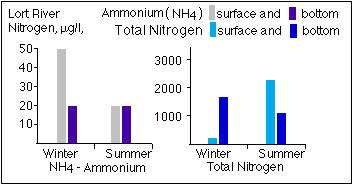
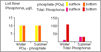
Water quality
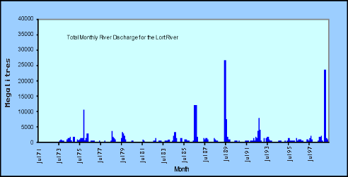
The Department of Environment has gauging stations on the Lort River, established in 1973. These gauging stations are part of a network of stations designed to provide discharge and water quality information throughout Western Australia.
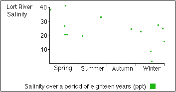
The Lort River is saline, at about 16 ppt (seawater is 35 parts per thousand). The river experiences a great range of salinity, being less saline after heavy rain in the catchments and hypersaline in riverpools over the summer. The Lort River is naturally saline.
Temperature for the Lort River and Young River are similar. The ranges are consistent with seasonal temperature fluctuations and slight differences from year to year. Water temperature is an important factor in the ecological health of a waterway, and is influenced by such things as shade, average water depth, ground water discharge and water colour. Factors such as pH and nutrient levels are also important to the health of the drainage system. pH values generally range from pH 6 to pH 8.
 |
 |
 |
|
 |
|
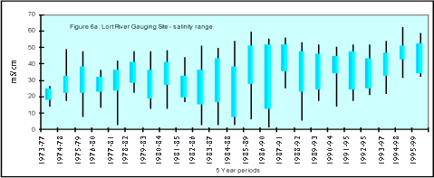
A similar increasing trend is evident in the Young River data. The graphs indicate increasing average salinity levels however continued monitoring is required to determine long-term salinity changes in the rivers.
Overall condition
The Young and Lort River are in good to excellent condition in comparison to other waterways in the State. The Young River and the Lort River have a wide buffer of foreshore vegetation along the length of the rivers. These river corridors have important ecological values in that they form important macrocorridors linking the coastal reserves to the Frank Hann National Park and Peak Charles. The river also has considerable habitat values, as there are riffle zones, extensive pools that retain water all year round, and overhanging vegetation along the entire length of the river. Stokes Inlet is also important as it supports a commercial fishery, is important for tourism and recreation. It has extensive wading bird habitat and supports a wide variety of marine and estuarine fish. The Department of Conservation currently manages Stokes Inlet.
The vegetative buffer along the Young and the Lort River needs little management to ensure its long-term protection, except in some areas of the river reserve where the buffer width is not adequate. In these sections, the foreshore width is less than 50 metres, and there are few remaining native plants in the understory. There is a section of the Lort River extending three kilometres south of the South Coast highway and eight kilometres north of the highway has been cleared to the water edge and weeds have invaded this section. Otherwise, there is little evidence of weed intrusion in the reserve except the boundary of the river reserves bordering onto agricultural lands and the intrusion of exotic grasses at road crossings. Overall, the rivers are in excellent condition, with little evidence of degradation.
Issues such as salinity and waterlogging are happening at a catchment scale. There has been a recorded increase in salinity levels and an increase in the frequency and volume at which the water is draining from the catchment since clearing. There are pockets of vegetation along the river showing signs of salinity and waterlogging. This is likely to be resulting in some further erosion of the riverbanks.
| Rating | |
|---|---|
| Hydrology and water quality | 4 |
| Foreshore vegetation | 3 |
| Aquatic vegetation | 2 |
| Aquatic habitat | 2 |
| Bank stability | 3 |
| Channel features and modifications | 2 |
| Other pollutants | Unknown |
| Scenic, recreational values | 2 |
| Conservation values | 2 |
|
Native Dog Swamp is a moderate priority and faces catchment issues such as salinity and waterlogging, and livestock threats. This wetland should be fenced from livestock as a high priority. Roberts swamp suite is a small nature reserve that is currently impacted by weeds, grazing/livestock and pollution from road runoff. This is a high priority wetland and options for management need to be further identified.
Further Information:
Ernest P. Hodgkin and Ruth Clark: Estuaries and Coastal Lagoons of South Western Australia: Stokes Inlet, Oldfield Estuary and Ten Others. Environmental Protection Authority, Perth, Western Australia: Estuarine Studies Series No. 5 June 1989.
South Coast Regional Land and Water Care Strategy: The Esperance-Sandplain Sub-region. Prepared by: the South Coast Regional Assessment Panel and the South Coast Regional Initiative Planning Team, February 1997.
Janicke, S: (2003) State of the Lort River Department of Water (unpublished review/report).