|
Stokes Inlet |
| Stokes Inlet at a glance | ||||
| Average annual rainfall over inlet: | 400 millimetres | |||
| Inlet area: | 14 square kilometres | |||
| Inlet length: | 10 kilometres | |||
| Inlet width: | 2 kilometres | |||
| Annual flow into Stokes Inlet: | 5 million cubic metres | |||
| Data selection | ||||
|
|
|
The land in the catchment has only recently been developed for agriculture. Most land was released for farming progressively from the late 1950's, firstly near the coast. The upper parts of the Stokes were released in the 1970s and 1980s.
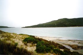
The inlet is located along a fault structure in a deep valley that once would have been permanently open to the sea. Approximately 4000 years ago, the estuary would have been tidal and a highly productive sheltered marine embayment similar to the Princess Royal Harbour at Albany. As the sea levels have retreated, the estuary is now closed to the sea by a high sand bar, which breaks for a few weeks at intervals of several years.
The inlet is commercially fished and many estuarine and marine fish species flourish in the estuary when salinity levels are not too extreme. The Stokes Inlet has considerable tourism and recreational values. The estuary is scenically attractive and is an important stop for many tourists.
Bar Opening
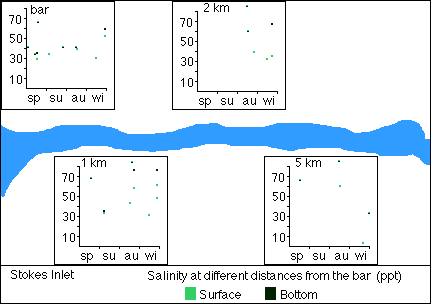
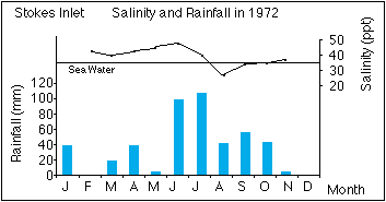
Stokes Inlet is separated from the ocean by a high sand bar. This is closed most of the time and opens briefly during high flow events. Consequently the salinity of the estuary varies greatly with river flow and evaporation. The bar reportedly opened in 1919, 1927 (or 1932) and then not until 1967. Since then the bar has opened more frequently. This is thought to be due to increased runoff since catchment clearing. High river flow is needed to open the bar, and estimations that flow of ten million cubic metres is required to break the bar naturally. Water levels in the estuary vary by nearly three metres, from 1.5 metres above to 1.5 metres below seal level.
Water quality
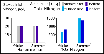
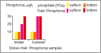
Salinity levels in Stokes Inlet ranges from 28 to 86 parts per thousand (seawater is 32 ppt). Generally the salinity of the estuary is less than that of seawater, but during summer can become hypersaline. Floodwater can reduce the surface salinity on the Inlet to that of the river water. When the bar is open and the sea water flows into the inlet from the ocean, salinity levels become more similar to the ocean. The temperature of the Inlet water ranges from 22.4 degrees to 14.5 (at the surface). There are only a few nutrient samples taken in the Stokes Inlet, however these indicate a minor degree of nutrient enrichment and the presence of blue-green algae supports this.
 |
 |
 |
|
 |
|
Fauna species in the inlet predominantly include estuarine species including the salt lake snail. Marine species can flourish when the bar is open and many juvenile prawns and mussels have been recorded. A few cockles and blue manna crabs have also been caught a few months after the bar has opened. Most species have been found near the bar while estuarine species are widely distributed throughout the inlet.
The composition of fish species depends on the timing and duration of the bar opening. Black bream are an estuarine species that also live in the Inlet and upstream river pools. This species is commercially fished. There are also a few non-commercial native species such as the common minnow and species of hardyheads and gobies that live in the estuary. When the bar opens, fertilised eggs, larvae and juveniles of a variety of marine species such as the Sea mullet enter the Inlet. These are fished for as long as conditions favour growth and survival. A number of marine species return to the sea to spawn at the next bar opening, and continue their marine existence until the next bar opening. There have been reportedly mass mortalities of fish in the Stokes Inlet in 1932, 1938 and 1983.
There are also many waterbirds that rely on the Stokes Inlet as it has extensive wading bird habitat.
Flow rates
Runoff from the catchments is small, an average of 0.9 millimetres, or less than 1% of the rainfall. The average discharge to Stokes Inlet is five million cubic metres. The main river flow is from July to October, however year and monthly averages do not give a true picture of the flow characteristics of the rivers. Major flood events occur at infrequent intervals, but generally only a small percentage of the annual rainfall passes down the rivers as stream flow. In the case of the Lort the percentage is less than 2%. The rest evaporates, is transpired by the vegetation and recharges the groundwater.
Management of the Inlet
Further Information:
Ernest P. Hodgkin and Ruth Clark: Estuaries and Coastal Lagoons of South Western Australia: Stokes Inlet, Oldfield Estuary and Ten Others. Environmental Protection Authority, Perth, Western Australia: Estuarine Studies Series No. 5 June 1989.
South Coast Regional Land and Water Care Strategy: The Esperance-Sandplain Sub-region. Prepared by: the South Coast Regional Assessment Panel and the South Coast Regional Initiative Planning Team, February 1997.