|
Young River |
| Young River at a glance | |||
| Catchment area: | 2073 square kilometres |
||
| Average annual catchment rainfall: | 540 mm | ||
| River length: | 95 kilometres | ||
| Annual discharge into Stokes Inlet: | 4700 Megalitres | ||
| Percentage cleared: | 59% | ||
| River health: | highly saline | ||
|
|
|
|
|
|
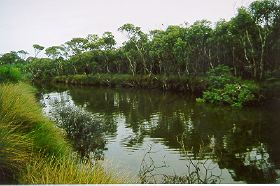
The Young starts about 90 kilometres north of the coast, on the Yilgarn plateau, which extends into the Mallee subregion. The mallee landscape is gently undulating, the rainfall is about 350 millimetres per annum and the soils are saline loams and sand over clay. Towards the coast, the terrain is more dissected as the rivers descend through siltstone to the coastal plain, where the annual rainfall is about 550 mm per annum. The main channels of the river are in the sandplain, and these pass through large bush blocks or naturally vegetated corridors, and are relatively natural. There are several long river pools, which form important fauna refuges during the dry summer.
Much of the lower parts of the catchment have been cleared and 60% of the catchment has been cleared since the late 1950s.
River flow is highly variable and dry years may be negligible. Some permanent river pools are maintained by springs. River degradation, especially the loss of riparian vegetation, sedimentation and eutrophication of river pools has resulted from clearing.
The river is naturally saline, with a great range in salinity. It is fresher following heavy rain in the catchment, but can be much more saline even when the water is still flowing freely. Salinity levels are thought to be elevated through extensive clearing in the catchments, which has also caused an increased amount of sediment to be washed from the highly erosive sandy soils, filling river pools and clogging channels.
Geology of the rivers
The Young and Lort River's headwaters straddle the geological boundary between the Yilgarn block and the younger Albany Fraser Province. The catchment creeks flow over sand and gravel plains, overlying granite rocks. The river then flows through metamorphosed granites and gneiss, and in parts carves a channel though the bedrock forming steep sided valleys 30-45 metres deep. Towards the coast, the river flows through sediment deposits before assuming youthful characteristics where it cuts through Eocene rocks.
Vegetation
The river was mapped and described in a broad scale by J.S. Beard as part of the Vegetation Survey of Western Australia. Beard differentiated two vegetation formations along the rivers including Shrublands and Low forest. The lower reaches of the Young and Lort River have been identified as being within the Esperance system of plant communities. The vegetation of this is mallee-heath characterised by Eucalyupus tetragona except where the surface sand is 90 centimetres or more in depth where there is a change to scrub heath with Banksia dominant. The valley slopes support mallees or E. occidentalis woodland. The upper reaches of the Young and Lort River are within the Lort vegetation system. This area contains a flat plain, which due to its flatness, is winter wet, and the soil becomes waterlogged. The general plant cover is mallee but there are scattered granite outcrops, patches of sand with mallee heath, clay patches with E. platypus low forest, and scattered pans of E. occidentalis. The mallee in this system is a distinct community with E. eremophila dominant in association with E. forrestiana. Other communities found in sandy patches include Banksia media, Grevillea asparagoides and Hakea spp. in the mallee. Deep sands brings in Eucalyptus tetragona and many other coastal mallee heath species. The catchment headwaters of the Lort are within an area of interior drainage around a number of lakes. Most of the area is covered with mallee and woodland.
Shrublands
Aquatic flora and fauna
The Young and Lort Rivers provide important habitat for many, varied aquatic flora and fauna. Frog species, native fish, macroinvertebrates are found in many of the river pools along the river. Aquatic flora such as Ruppia megacarpa is found growing in many pools - providing habitat and food for native fish. Macroinvertebrates or aquatic bugs consist of worms, snails, crustaceans (prawns and marron) and insects (such as mayflies, stoneflies, beetles, and bugs). Many macroinvertebrate species are found in the waterways throughout the Young/Lort River catchment.
Water quality
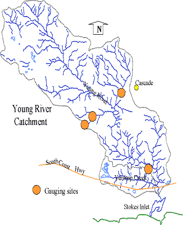
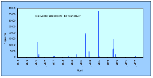
The Department of Environment has gauging stations on the Young River, established in 1971. These gauging stations are part of a network of stations designed to provide discharge and water quality information throughout Western Australia. Another site in the Young River catchment, near Cascade, was installed in 1974 and decommissioned in 1998.
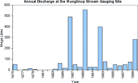
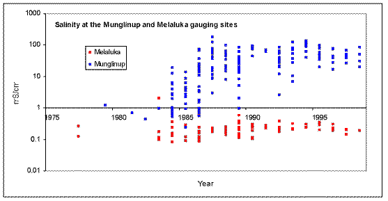
Experimental gauging stations have been established in the mid-1970's on a tributary of the Young River. These sites - Melaluka and Munglinup were established prior to local land clearing.
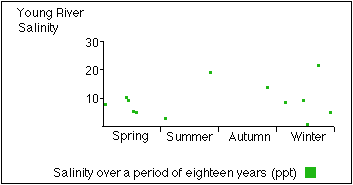
The Young River is saline, at about 6 ppt (seawater is 35 parts per thousand). The river experiences a great range of salinity, being less saline after heavy rain in the catchments and hypersaline in riverpools over the summer. The Young River is naturally saline.
Surveyor General Mr J.S Roe on his 1848 expedition, records the saline character of the river. "...and at 10 miles from its mouth quitted it.... Where I quitted this river, it was coming from the Northwest and lay in irregular pools, nearly salt".
Temperatures for the Lort and Young Rivers are similar. The ranges are consistent with seasonal temperature fluctuations and slight differences from year to year. Water temperature is an important factor in the ecological health of a waterway, and is influenced by such things as shade, average water depth, ground water discharge and water colour. Factors such as pH and nutrient levels are also important to the health of the drainage system. pH values generally range from pH 6 to pH 8.
 |
 |
 |
|
 |
|
The vegetative buffer along the Young River needs little management to ensure its long-term protection, except in some areas of the river reserve where the buffer width is not adequate. In these sections, the foreshore width is less than 50 metres, and there are few remaining native plants in the understory.
Salinity and waterlogging are happening at a catchment scale. There has been a recorded increase in salinity levels and an increase in the frequency and volume at which the water is draining from the catchment since clearing. There are pockets of vegetation along the river showing signs of salinity and waterlogging. This is likely to be resulting in some further erosion of the riverbanks.
| Rating | |
|---|---|
| Hydrology and water quality | 4 |
| Foreshore vegetation | 3 |
| Aquatic vegetation | 2 |
| Aquatic habitat | 2 |
| Bank stability | 3 |
| Channel features and modifications | 2 |
| Other pollutants | Unknown |
| Scenic, recreational values | 2 |
| Conservation values | 2 |
|
What does the gauging data show?
In the upper Young catchment, two gauging stations - Melaluka and Munglinup, were installed on a small tributary before local land clearing.
Further Information:
Ernest P. Hodgkin and Ruth Clark: (1989) Estuaries and Coastal Lagoons of South Western Australia: Stokes Inlet, Oldfield Estuary and Ten Others. Environmental Protection Authority, Perth, Western Australia: Estuarine Studies Series No. 5
South Coast Regional Land and Water Care Strategy: The Esperance-Sandplain Sub-region. Prepared by: the South Coast Regional Assessment Panel and the South Coast Regional Initiative Planning Team, February 1997.
Bowyer, J. (2001) Lort and Young Rivers Catchment, Rapid Catchment Appraisal Dept of Agriculture, Government of Western Australia, Resource Management Technical Report 231.
Janicke, S. and Michael, M. (2004) State of the Young River Department of Water (unpublished report).
Esperance Regional Forum: (2006) Young River Catchment Plan 2006.