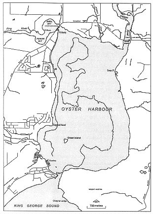
Oyster Harbour
|
Oyster Harbour is north-east of the town of Albany. The harbour is roughly rectangular in shape and about five kilometres long and three kilometres wide. Its total area is about 16 km2. The King and Kalgan rivers enter the harbour on its northern shore. Most of the fresh water that goes into the harbour comes from these rivers. The harbour was formed when the sea rose and drowned a river valley during the Pleistocene era, about 130 million years ago.
About one third of Oyster Harbour is less than two metres deep. It's shallow along its eastern shore but more than five metres deep near the western shore and in the southern basin. An entrance channel less than 200 m wide joins Oyster Harbour to King George Sound at Emu Point. The Emu Point peninsula is the eastern end of a beach ridgeplain between King George Sound and Lake Seppings. The sandy spit is unstable and work has been done to stabilise the Point. The channel is scoured to over ten metres deep.
The harbour's narrow entrance channel helps the tides create a good movement between the harbour and the waters of King George Sound. The flushing time for the harbour is about 10-20 days when river flow is low. In contrast, other estuaries along the southern coast have flushing times of months or years. The harbour water is nearly as salty as sea water. It is almost a marine environment for the animals and plants.
The mudflats of Oyster Harbour, like the ones in Princess Royal Harbour, are a habitat for migratory wading birds. These habitats are in danger in certain areas: the creek draining from Lake Seppings into Oyster Harbour; and an area to the south of Lower King Bridge on the western shore of the harbour. Trail bikes and other vehicles can damage the habitat in these places. The eastern side of the harbour is also a roosting area for wading birds, especially in the summer months. It's harder to get to this area, so it's less likely to be destroyed by human activity.
The margins of the harbour have different sorts of vegetation. Low-lying areas around Oyster Harbour have saltmarsh fringing forests. These wetlands are extremely important and productive parts of the estuarine ecosystem. They are a major source of detritus, which many creatures eat. They are also important feeding and roosting areas for waterbirds, including many migratory waders. A lot of these waders are protected under international agreements. There are three main saltmarsh fringing forests in Oyster Harbour.
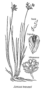
There is an extensive wetland area on the south-western shore where Yakamia Creek and a drain from Lake Seppings enter the harbour. The sedge swamp is dominated by Astartea fascicularis with Acacia myritfolia and Oxylobium lanceolatum. Juncus kraussii dominates the outer fringe, backed by Melaleuca cuticularis trees and Baumea juncea.
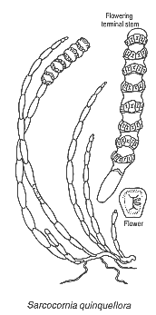
There are extensive samphire flats in the shallows upstream and downstream of the Lower King Bridge with saltmarsh plants dominated by Sarcocornia quinqueflora and Suaeda australis in the wetter parts, the larger Halosarcia halocnemoides and Halosarcia lepidosperma on the drier parts, and Junus kraussii and Melaleuca cuticularis on rising ground behind.
The south-eastern shore of the harbour has a narrow samphire fringe with Sarcocornia quinqueflora, Suaeda australis and Halosarcia spp. with patches of Junus kraussii and Melaleuca cuticularis behind.
There's a residential area at Emu Point which stretches across the point, linking the shores of Oyster Harbour with Middleton Beach. This is important for recreation and tourism. There is tourist accommodation, recreation facilities and swimming beaches. Emu Point is currently unsewered and nutrients from septic tanks probably get into the harbour.
To the north of Emu Point a marina has been excavated in the harbour shore. There is a ramp and slipway, used mainly by commercial fishing boats. Fish processing operations are also carried out here, and there is a recently developed oyster farm. The management of marina operations is important for the water quality of the harbour.
Bayonet Head is a prominent headland on the western shore north of Yakamia Creek. The headland has outstanding views over the harbour, with a lookout. The area between Bayonet Head and Lower King has been earmarked, along with the Yakamia Creek area, as the main growth area for Albany. The area will have houses, shops and a school. Bayonet Head has been sewered. The Bayonet Head Structure Plan is being prepared at time of writing.
 |
The Lower King Bridge crosses the King River at the river mouth. There is a recreation reserve on the north-eastern side of the bridge. A picnic area, boat ramp, BBQ and toilet are located here. There's some tourist accommodation back from the foreshore area.
Land is being subdivided on the northern shore of the harbour between the King and Kalgan rivers. A special rural subdivision has been developed here, and more and more people want to use the foreshore. There is an anthropological reserve protected under the Aboriginal Heritage Act 1972 which marks the location of historic Aboriginal fish traps. It has a tourist trail, with educational signs. It's important to protect this site from uncontrolled access.
Also on this northern shore is Johnston Creek, which drains farmland to the north. The Kalgan River enters Oyster Harbour on the harbour's north-eastern corner. There's a boat mooring area at its mouth. Just north of the bridge is a recreation reserve with a caravan park, picnic area and boating facilities. Canoes can be hired here.
The eastern shore of the harbour is mainly private property to the north, with special rural or rural lots and reserve land to the south. Much of the northern area has been cleared for agriculture. There is very little access to foreshore areas available on this shore of the harbour. As more and more land is subdivided, there will be a greater demand for access to the foreshore for recreation. Foreshore reserves have been set aside for recreation on one of the major subdivisions, but the reserve is narrow in places and isn't really adequate for either recreation or protecting the fringing vegetation.
A national park, extending eastward almost to Taylors Inlet, stretches down to the water's edge in the south-eastern corner of the harbour. This area is still vegetated and contains several species of rare plants and animals. The vegetated slopes of Mount Martin opposite Emu Point are managed by the Town of Albany for recreation purposes.
It's relatively difficult to get to foreshore areas within the national park and recreation reserve. Tracks into the area opposite Emu Point are very rough and can only be used by four-wheel-drive vehicles. However, boats can get across the channel to the beach and granite rocks. Walk trails and toilets are being put in. This area, when viewed from Emu Point, is an attractive backdrop to the harbour.