|
Princess Royal Harbour |
| Princess Royal Harbour at a glance | |||
| Average annual catchment rainfall: | 1100 millimetres | ||
| Harbour area: | 29 square kilometres | ||
Nutrient Audit |
|||
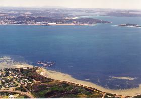
Discharge into the harbour is minimal - there are two ephemeral creeks on the peninsula and a number of agricultural drains along the western shore, along with stormwater from the city and the port.
The harbour has extensive intertidal areas and shallow banks important to waterbirds and marine flora and fauna, and there is a significant fishery. Fringing vegetation, although not extensive, is healthy and highly variable. It is, however, steadily being encroached upon by urban development.
Industrial pollution has long been a problem in the harbour, taking a variety of forms, but the most pronounced have been nutrient enrichment, leading to the excessive growth of algae and its smothering all but 10% of the seagrass beds. Heavy metal contamination of the sediments led to the closure of the western third of the the harbour to fishing for several years.
In 2005 a project (Our Living Rivers) was set up to collect and analyse data, enabling the Department of Water to monitor the health of the river over time and help determine what systems need better protection. In spring 2006 and 2007 samples were taken from the river system to assess the quality of the water and habitat as well as the presence of fish and macroinvertebrates. One site was sampled on Limeburners Creek, which feeds into the harbour.
Further Information:
Albany Waterways Resource Book: Water and Rivers Commission 1999
South Coast Regional Land and Water Care Strategy: The Albany Hinterland Sub-region. Prepared by the South Coast Regional Assessment Panel and the South Coast Regional Initiative Planning Team: December 1996