
|
Waychinicup River |
| Waychinicup River at a glance | |||
| Catchment area: | 145 square kilometres |
||
| Average annual catchment rainfall: | 760 millimetres | ||
| River length: | 17 kilometres | ||
| Mean annual flow: | 8,560 Megalitres | ||
| Percentage cleared: | 41% | ||
| River health: | fresh to marginal | ||
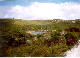
The Waychinicup River is 17 kilometres long and has a number of small pools along its length. The valley is incised some 40-60 metres deep into the granite for three kilometres from the coast with smooth slopes and occasional rock outcrops. Upstream beyond the granite valley the river flows through a flat swampy floor of spongolite and sandplain from an elevation at its headwaters near the South Coast Highway of 100 metres above sea level. The lower valley of the river is located within the picturesque Waychinicup National Park.
In 2005 a project (Our Living Rivers) was set up to collect and analyse data, enabling the Department of Water to monitor the health of the river over time and help determine what systems need better protection. In spring 2006 and 2007 samples were taken from the river system to assess the quality of the water and habitat as well as the presence of fish and macroinvertebrates. Three sites were sampled on the Waychinicup River.
Further Information:
South Coast Regional Land and Water Care Strategy: The Albany Hinterland Sub-region. Prepared by: the South Coast Regional Assessment Panel and the South Coast Regional Initiative Planning Team December 1996.

