|
Hay River |
| Hay River at a glance | |||
| Catchment area: | 1298 square kilometres | ||
| Average annual rainfall over catchment: | 760 mm | ||
| River length: | 80 kilometres | ||
| Annual discharge volume into inlet: | 69,400 Megalitres | ||
| Percentage cleared: | 70% | ||
| Extent of tidal influence: | 5 kilometres | ||
| River health: | marginally saline to brackish | ||
| Data selection | |||
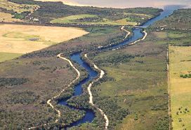
The fringing vegetation of the river valleys represents a significant ecological corridor connecting patches of remnant bush along the banks of the river. In 1995 only 39% of the Hay River foreshore that bordered agricultural land was fenced off, while 173 hectares of the Hay River foreshore area were identified as in need of revegetation. A total of 77 kilometres of the Hay River was surveyed, and of this length, about 42% of the riparian zone was pristine, 22% degraded, 36% erosion prone, and a small section (0.5 %) was categorised as weed infested. Overall, about 173 hectares of river valley embankment and foreshore requires revegetation. In areas where farmland adjoined the Hay River, approximately 38.6% of the foreshore was actually fenced. A further 84.9 kilometres of fencing is required. The middle and lower sections of the river are very scenic and contain foreshores generally of a high quality. Even so, points of erosion and subsidence and sections of extensive degradation do occur. The increasingly saline upper half of the river is degraded, exhibiting erosion along fire breaks located within the floodplain of the river valley, siltation and some vegetation die-off, as a result of salinisation.
The river water quality varies from marginal to brackish, with an elevated salinity caused by clearing in the upper catchment. The water flows all year.
Despite extensive clearing within the catchment, loss of vegetation along major streamlines is not yet great, and the main channels are relatively natural. However, there are some sections reduced to more than agricultural drains on the eastern tributaries, where clearing is more extensive.
In 2005 a project (Our Living Rivers) was set up to collect and analyse data, enabling the Department of Water to monitor the health of the river over time and help determine what systems need better protection. In spring 2006 and 2007 samples were taken from the river system to assess the quality of the water and habitat as well as the presence of fish and macroinvertebrates. Nineteen sites were sampled on the Hay River system and three on the Mitchell River tributary.
Further Information:
South Coast Regional Land and Water Care Strategy: The Albany Hinterland Sub-region Prepared by: the South Coast Regional Assessment Panel and the South Coast Regional Initiative Planning Team: December 1996.