|
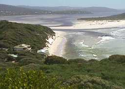
Wilson Inlet |
| Wilson Inlet at a glance | |||
| Average annual rainfall: | 1200 millimetres | ||
| Inlet area: | 48 square kilometres | ||
| Inlet depth: | Two - five metres | ||
| Water Quality Nov 2002 (648K) | |||
| Community Report 5 (508K) | |||
| Community Report 6 (488K) | |||
| Community Report 7 (1M) | |||
| data | |||
The headwaters of the Hay River are mainly land with laterite and sand over laterite country with many salt lakes and swamps. Most of the Denmark River catchment and the middle reaches of the Hay River are in dissected granite country with some extensive swampy patches in the upper reaches of the Denmark River. Much of this is still forested and there is little risk of erosion of the yellow mottled soils and dissected laterites. On the lower slopes, nearer the estuaries, there are areas of Tertiary sandstone and spongolite (Pallinup Siltstone) with low gradients, and these rocks also underlie coastal plain sediments. The smaller rivers, such as the Sleeman and the lower tributaries of the larger rivers have much of their catchments on these rocks. The soils are mainly swampy, sandy and tannin stained, resulting from the acid nature of the drainage water carrying organic matter. The north of Wilson Inlet catchment features the western part of a large plain between 200 and 240 metres above mean sea level, which is dissected by the headwaters of the Hay and Denmark Rivers. The land falls away in the south where the higher order streams approach Wilson Inlet. Much of this area demonstrates more diverse topography as the higher order streams incise the landscape. This is more so in the west of the catchment, where the Denmark River makes its way to the inlet through a more hilly terrain.
Wilson Inlet is fringed with the rush Juncus kraussi and the salt-tolerant paperbark tree Melaleuca cuticularis, around the inlet, along the channels and for a short distance up the rivers. Juncus forms single species stands near the mouth of the inlet, or mixed with samphire (Sarcocornia quinqueflora), Samolus repens and occasional Meleleuca cuticularis in salt marshes. In disturbed areas of salt marshes there are introduced grasses: salt water couch, Polypogon monspeliensis and buffalo grass. A second community occurs in flatter area behind the Juncas/Melaleuca community; this is dominated by the sedges Isolepis nodosa and Baumea juncea and the herb Samolus repens.
These areas provide important feeding and roosting areas for waterbirds including waders, and waterfowl. Migratory waders also feed in these areas putting on fat during the summer months to prepare for their long journey to their breeding grounds in the northern hemisphere. Groups of migratory waders observed in these areas include sandpipers, plovers, stilts and stints. Many of these birds are protected by international agreements.
Wilson inlet is thought to be suffering the effects of eutrophication because of excessive epiphytic algae growth on the prolific Ruppia and the heavy build up of rotting organic matter on the western shores.
This has lead to considerable local debate on the best location and timing to breach the bar, which is done early to prevent flooding of agricultural land, in order to best flush nutrients from the inlet and maintain more pleasing marine conditions.
Further Information:
South Coast Regional Land and Water Care Strategy: The Albany Hinterland Sub-region. Prepared by: the South Coast Regional Assessment Panel and the South Coast Regional Initiative Planning Team: December 1996