|
Fitzgerald Inlet |
| Fitzgerald Inlet at a glance | |||
| Inlet area: | seven square kilometres |
||
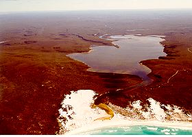
The Fitzgerald Inlet is cut into spongolite rock and is bordered by spectacular cliffs of spongolite. Its bar opens with a similar frequency to the Hamersley Inlet bar. Heavy rain in January 1990, following wildfires in the National Park, led to high river flows, erosion of sediments from the denuded soils and river beds, and caused the bars on both the Hamersley and Fitzgerald Rivers to break.
The inlet is on the register of wetlands of national significance.
Further Information:
South Coast Regional Land and Water Care Strategy: The Fitzgerald-Biosphere Sub-region. Prepared by the South Coast Regional Assessment Panel and the South Coast Regional Initiative Planning Team March 1997.