
|
Fitzgerald catchment |
| Overview |
|
Waterways |
Description
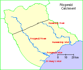
The Fitzgerald catchment comprises St Mary's, Hamersley, and Fitzgerald Inlets together with the catchments of the Fitzgerald River and its tributaries plus some of the small creeks, drains and land which drains to the inlets.
Most of the information presented here pertains to a more restriced site comprising Fitzgerald Inlet and associated marshes, Dempster Inlet; (2.5 kilometres north-east), "Charles Bay Lake" (three kilometres south-west; also known as Charles Bay Inlet and "Lake Nameless") and the lower and middle reaches of the Fitzgerald River and Susetta Rivers (within Fitzgerald River National Park).
Nearby wetlands: Culham Inlet (ESP002WA) is 40 kilometres east north-east; Hamersley Inlet is 25 kilometres east north-east; Gordon Inlet is 18 kilometres south south-west.
Landform: Macroscale irregular-elongate coastal lagoons with narrow connections to the sea, macroscale irregular sumpland, microscale (width) irregular creeks, microscale ovoid sumplands.
Poor drainage of the area has resulted in rain-borne salt accumulating in deep soil profiles. Clearing of the native vegetation has caused groundwater levels to rise and mobilise these salts.
Geological setting: The system is situated in the Yilgarn Craton (Bremer Basin), in the Pallinup siltstone (spongolite), with extensive cliffs to 40 metres at the wetland margins (Fitzgerald Inlet and River, Charles Bay Lake), and in the Mt Barren schist, with low margins (Dempster Inlet). Partly vegetated sand dunes up to one kilometre wide occur between the wetlands and the sea. Marshes occur in former creek meanders and deltaic deposits. Lagoon beds are composed of sandy mud and shell.
There is a wide variety of soil types in the sub-region:
Climate: Rainfall is relatively low, decreasing from around 500 millimetres on the coast to 400 mm in the upper catchment. Median and mean annual rainfall at Bremer Bay are 629 mm and 628 mm respectively, mostly falling in May-September, with significant summer rain in many years; annual evaporation is about 1800 mm.
Compared to the west coast, this area has a more uniform rainfall distribution, relatively fewer hot winds, and more cloud cover, with low risk of frost.
Water supply: Fitzgerald River and its major tributary Susetta River originate 70 kilometres north-west and enter the west end of Fitzgerald Inlet, as does a minor creek originating ten kilometres west north-west. Dempster Inlet is supplied by Copper Mine Creek, originating 12 kilometres north-west, and creeks off Mid Mount Barren, originating five to seven kilometres north and east north-east; there is also some groundwater seepage (Taylor Spring). Charles Bay Lake is fed by creeks originating seven kilometres west north-west (catchment area 5000 hectares). Creek catchments are undisturbed; river catchments are mostly undisturbed but partly cleared near the headwaters. The inlets have sea outlet channels about one kilometre long, 25-100 metres wide and five metres deep; the channel bars are broken infrequently and briefly, e.g. 1963, 1971, 1978, 1988, 1990.
Inundation: The rivers, creeks and marshes are seasonal. The lagoons and lake undergo cycles of flooding and drying lasting from one to several years and thus are nearer 'seasonal' than 'permanent'. At times water is confined to several pools and channels at river mouths and sea outlets.
Water depth: Fitzgerald River: Up to two metres; Fitzgerald Inlet: Maximum 1.5 metres, usually less than1 metre, often dry; Dempster Inlet: Up to two metres, often dry; Charles Bay Lake: depth varies by several metres, sometimes dry.
Water salinity: Rivers: Naturally saline to hypersaline, but probably more saline since commencement of farming in upper catchment; Inlets and Lake: 5-10 ppt when flooded, briny when drying out.
Water colour: None.
Ecological role: The system is a major drought refuge area for the Chestnut Teal (Anas castanea) in WA.
Plant structural formations: Low shrubland (samphire) in periform arrangement in the marshes; open-scrub and low shrubland in zoniform arrangement in some parts of the larger waterbodies; surrounding areas support open-heathland to low open-forest.
A good example of naturally saline rivers, and undisturbed coastal lagoons (with protected catchments) that exhibit cycles of flooding and drying of variable length.
Notable flora:
Threatened species: None.Composition: 13 species have been identified in the low shrublands (marshes), including the shrubs Atriplex cinerea, Halosarcia indica subspecies bidens, Sarcocornia quinqueflora and Suaeda australis and grasses (e.g. Sporobolus virginicus) and sedges (e.g. Gahnia and Juncus spp.). Open-scrub is pre-dominantly Melaleuca cuticularis; much of it has been killed by recent floods. Aquatics include Ruppia megacarpa. Middle reaches of the Fitzgerald fringed by Eucalyptus occidentalis low open woodland with Acacia microbotrya and Acacia ixiophylla.
General Comments: Tallerack mallee heath and Banksia scrub heath occur extensively on the sandy plains. The heavier gravel and clay soils and breakaways support Swamp Yate, Moort or mallet woodlands, mallee or mallee heath. The shallow loams overlying granites of the Yilgarn Craton support Swamp Yate woodland, Sheoak woodland and broombush thicket. Seasonally wet depressions in clay soils are widespread and support tall woodlands of Swamp Yate.
The Fitzgerald River National Park provides an exceptional area of plant diversity, accounting for some 20% of WA's described vascular flora. The Fitzgerald area is recognised as one of three nodes of species richness in the state.
Notable fauna (waterbirds):
Threatened species: Hooded Plover Charadrius rubricollis occurs in the system (two birds counted).Breeding: No breeding records but Chestnut Teal probably breed along the Rivers and in/near the marshes.
Composition: 29 species recorded in the Inlets, four listed under treaties; includes four darters and cormorants, ten ducks and allies and eight shorebirds. Another five species recorded from pools on the Rivers, e.g. Spotless Crake Porzana tabuensis.
Moulting: Large numbers of Australian Shelduck Tadorna tadornoides occur at Fitzgerald Inlet (up to 1212, November 1990) and probably moult there in spring.
Migration stop-over: Three migrant shorebirds recorded, only Red-necked Stint Calidris ruficollis in numbers (up to 87), but further surveys may reveal greater use.
Numbers: The highest numbers of waterbirds (waterfowl only) counted at each wetland in the system have been 3761 at Charles Bay Lake (March 1991), 1857 at Fitzgerald Inlet (November 1990), 1330 at Fitzgerald River lower reaches (March 1991) and 388 at Dempster Inlet (November 1988). The whole system supported 5812 waterfowl in March 1991. The most abundant species are Chestnut Teal (up to 1550, Charles Bay Lake, March 1991, regional/WA rank 1), Australian Shelduck and Grey Teal Anas gibberifrons (835, Charles Bay Lake, March 1991). All the wetlands support Chestnut Teal (e.g. Fitzgerald Inlet 270) and Fitzgerald River lower reaches is also regionally significant for the species (790 March 1991, rank 5).
Notable fauna (other taxa):
Threatened species: None.Composition: The fish fauna of the site is generally impoverished due to periods of isolation from the sea and high salinities, but eight species occur, including Galaxias maculatus, Atherinosoma elongata, Black Bream Acanthopagrus butcheri and Six-spined Leatherjacket Meuschenia freycineti. The inlets are known to support seven bivalve taxa, a gastropod and the shrimp Palaemonetes australis; these comprise a few estuarine, several marine and some salt lake species. Five species of frog have been recorded along the middle reaches of the Fitzgerald: Heleioporus albopunctatus, H. eyrei, Limnodynastes dorsalis, Pseudophryne guentheri and Ranidella pseudinsignifera.
The park is rich in vertebrate fauna, supporting more species than any other conservation reserve in the south west. The richest area for mammal and reptile species is the uplands, with the inlets, rivers, swamps and lakes providing for the greatest diversity of bird species.
Social and cultural values:
Research: Some research by RAOU and others (several waterbird surveys, 1981-88), WADCALM (seven waterfowl surveys, 1988-91) and Hodgkin and Clark (estuarine studies).Recreation: Parts of the site are popular for touring (4WD access only), bush-walking, nature study and fishing.
Aesthetics: Dempster Inlet is within a "wilderness" zone in the park and Fitzgerald River is classified as "scenic". The juxtaposition of inlet waters, spongolite cliffs, uncleared slopes, rugged peaks (Mid Mount Barren), beaches and ocean forms one of the most distinctive landscapes in the region.
Land tenure and land use
Land tenure:
On site: Marine waters (inlets only). Remainder of site is part of Fitzgerald River National Park (Reserve 31738).Surrounding area: Fitzgerald River National Park.
Current land use :
On site: Nature conservation and recreation.Surrounding area: Nature conservation, recreation, cereal cropping and pasture grazing (only in upper catchment of rivers) and very low human population (outside the park). All wetlands of this site have buffers of native vegetation more than one kilometre wide.
Explorers and botanists preceded settlers. The discovery of brown coal in the Fitzgerald valley prompted more settlers, and pastoral and sheep grazing formed the basis for most settlement.
The district is not suitable for cropping, although superphosphate was used successfully. Post World War Two settlement was encouraged by the government, with wheat, oats and barley being grown.
Current uses are wool, sheep, wheat, barley, oats, lupines, field peas, beef, fat lambs, emus, deer, fish, mining and wildflowers.
Conservation
Threats: Some evidence for further salinisation of inflow rivers.
Measures taken: An official WADCALM Management Plan exists (1991) and contains recommendations on land tenure and fishing in the system. Fitzgerald River National Park is a 'Man and Biosphere Reserve'. The site is included on the Register of the National Estate.
Management authority and jurisdiction: The Park is managed by WADCALM for NPNCA. Their regional office is located at Albany.
Management Reports
Management plan:
in State of the Waterways in the Fitzgerald River Catchment (2000) Water and Rivers Commission
Copies of this report are available from the Albany office of the Department of Water.
