|
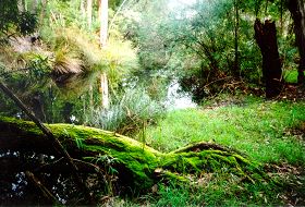
Deep River |
| Deep River at a glance | |||
| Catchment area: | 1581 square kilometres |
||
| Average annual catchment rainfall: | 800-1400 millimetres | ||
| River length: | 120 kilometres | ||
| Annual discharge volume into inlet: | 172M cubic metres | ||
| Extent of tidal influence: | Six kilometres | ||
In 2005 a project (Our Living Rivers) was set up to collect and analyse data, enabling the Department of Water to monitor the health of the river over time and help determine what systems need better protection. In spring 2006 and 2007 samples were taken from the river system to assess the quality of the water and habitat as well as the presence of fish and macroinvertebrates. Five sites were sampled on the Deep River system.
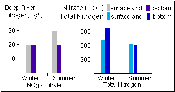
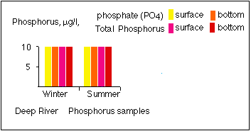
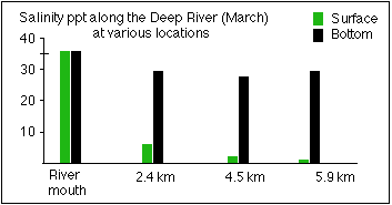
Very little of the Deep River's catchment is cleared, and its water is fresh and low in nutrients. There is a high content of suspended matter of silt- and clay-sized particles in winter. The lower river has a navigable channel from one metre to five metres in depth. Salinity varies along the length of the river.
 |
 |
 |
|
 |
|
Further Information:
An Inventory of Information on the Estuaries and Coastal Lagoons of South Western Australia. Nornalup and Walpole Inlets and other estuaries of the Deep and Frankland Rivers. Environmental Protection Authority; Perth, Western Australia. Estuarine Studies Series Number 2: March 1988