|
Walpole-Nornalup |
| Walpole-Nornalup Inlet at a glance | ||||
| Inlet area: | 13.2 square kilometres |
|||
| Data selection | ||||
 The inlets are surrounded by National Park of tall karri and tingle forest on hilly land to the north and coastal heath on tall dunes to the south. It is one of the few places on the coast where karri forest comes down to the sea, and has unmatched scenic beauty of immense heritage, lifestyle and tourism value.
The inlets are open to the ocean all year, and are connected by a one kilometre long channel. The channel from Nornalup Inlet to the sea varies from year to year, cutting through the mobile sands of the flood tide delta, and while there is no complete bar, the entrance to the sea is shallow (less than one metre) on the ebb tide.
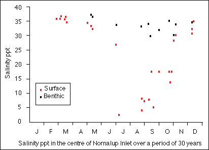
In summer the salinity of Nornalup Inlet is approximately that of sea water (35 ppt) for about six months. The deep water is rarely less than 30 ppt at any time, but in winter surface salinity can fall to 10 ppt or less.
In 2005 a project (Our Living Rivers) was set up to collect and analyse data, enabling the Department of Water to monitor the health of the river over time and help determine what systems need better protection. In spring 2006 and 2007 samples were taken from the river system to assess the quality of the water and habitat as well as the presence of fish and macroinvertebrates. Two sites were sampled in the Walpole River, which discharges into the Walpole Inlet.
The summer temperature range for the Nornalup Inlet is 20 to 22°C., and in winter it ranges from 12 to 17°C. at the surface. The deep water is often several degrees warmer.
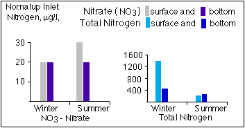
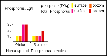
Nutrient levels are low.
 |
 |
 |
|
Further Information:
An Inventory of Information on the Estuaries and Coastal Lagoons of South Western Australia. Nornalup and Walpole Inlets and other estuaries of the Deep and Frankland Rivers. Environmental Protection Authority; Perth, Western Australia. Estuarine Studies Series Number 2: March 1988