
|
Gairdner catchment |
| Overview | 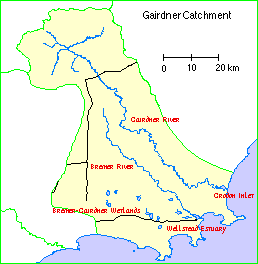 |
Waterways |
The Gairdner catchment comprises Gordon Inlet and Wellstead Estuary, together with the catchments of the Gairdner and Bremer Rivers and their tributaries plus some the small creeks, drains and land which drains to the inlet or estuary.
Climate
Rainfall is relatively low, decreasing from around 600-700 millimetres on the coast to 400 mm in the upper catchment. Unseasonal heavy rains and floods have a significant impact on the estuarine ecology.
Compared to the west coast, this area has a more uniform rainfall distribution, relatively fewer hot winds, and more cloud cover, with low risk of frost.
Soils and landforms
The upper parts of the catchment lie in the Yilgarn Block of the plateau and the lower reaches are on the Albany-Frazer geological province. The hard granitic bedrock is exposed in the river valleys. Within about 40 kilometres of the coast this rock is overlain by spongolite rock, composed of clays, sponge spicules, sand, and scarce fossil shells. This softer rock is more readily eroded and has been cut into steeply sloped valleys and cliff near the estuaries.
Much of the catchment between the valleys is covered by sandplain. Calcareous, Pleistocene dune rock and recent mobile dune sands border the coast and the lower reaches of the estuaries, where they overlie the older rocks.
Lighter soils are common on the sandplain. In some places the topsoil of almost pure sand is more than 30 centimetres deep. Alluvial soils occur mainly in narrow strips along the rivers and their major tributaries.
Flora
Where the land has not been cleared much of the vegetation is high shrubland formations with shrub or mallee eucalypts predominating. Mallees are common on the sandplain, with Flat-topped Yate commonly found in the alluvial soils along the rivers. Patches of mixed heath and low heath of Proteaceae, Myrtaceae and Leguminoseae are present. The heath vegetation merges into and forms the understorey to the high shrubland communities. Low forests of Eucalypts occur locally on scarp slopes.
The narrow coastal plain has an Acacia and Agonis scrub alliance. Banksia are dominant on the drift sand inland.
Land use
Much of the catchment area is alienated, cleared for pasture. Large pastoral leases were cleared in the mid 1800s. Settlement was encouraged in the 1920s, with soldier settlement grants, and there was wide-scale clearing in the 1950s and 1960s. Cleared land is used mainly for sheep grazing and seed crops. Current uses are wool, sheep, wheat, barley, oats, lupins, field peas, beef, fat lambs, emus, deer, fish, mining and wildflowers. The area around Bremer Bay is also being considered for wine grapes.
The town of Jerramungup is in the catchment area, with the much smaller town of Bremer Bay down on the coast. The Fitzgerald River National Park also forms part of the catchment.
Wetlands Surveys
The following wetlands in the catchment have been surveyed and "report cards" prepared. The reports are available as PDF files. The locations of the wetlands can be seen on the survey map and in the overall survey report.
Management Reports
Management recommendations:
in Bremer River and Devils Creek River Action Plan (2001) Water and Rivers Commission
Copies of these reports are available from the Albany office of the Department of Water.
