|
Bremer River |
| Bremer River at a glance | |||
| Catchment area: | 716 square kilometres |
||
| Average annual rainfall over catchment: | 400-600 millimetres | ||
| River length: | 70 kilometres | ||
| Annual discharge volume into Wellstead Estuary: | 2.7M cubic metres | ||
| Percentage cleared: | 80% | ||
| River health: | highly saline | ||
| |
|||
| Stories of the Bremer River and Wellstead Estuary (450K PDF file) | |||
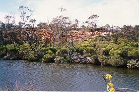
The Bremer River arises at the edge of the Yilgarn Plateau 70 kilometres north of the coastline. The rainfall varies considerably from year to year, especially in the inland parts of the catchment, causing large variations in streamflow. Intense summer rain from cyclonic depressions occur occasionally, and can cause large river flows and flooding. As the river descends to the coastal plain, the valley becomes steeper and more dissected through Pallinup Siltstone (spongolite) which overlays the ancient granites.
The characteristics of the Bremer River are relatively similar to the Gairdner and Pallinup Rivers, with over 80% of the catchment cleared. As a result of clearing, the river water is saline (3-4 ppt), both from the connate salt in the spongolite and cyclic salt deposited over millenia in rain. Salinity now varies from about 10% of sea water (3-4 ppt) when the water is flowing, to 150% of sea water (over 50 ppt) in stagnant pools in the river bed in summer. Apart from these pools the channel is dry much of the time.
 Large areas of the catchment are covered with sandy topsoils, which is easily eroded by wind or water. It is assumed that sedimentation in the river and estuary has increased since clearing, but the rate of increase is unknown. Even if further loss of soil into the river was stopped immediately, there may be sufficient loose sediments in the river-bed to contribute to estuary siltation for decades.
Much of the main channel lies within a vegetated corridor, with the lower to middle reaches of the river being relatively natural. Upstream the river degenerates, and the tributaries are sometimes no more than an agricultural drain.
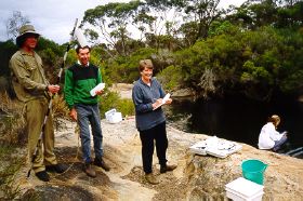
In 2005 a project (Our Living Rivers) was set up to collect and analyse data, enabling the Department of Water to monitor the health of the river over time and help determine what systems need better protection. In spring 2006 and 2007 samples were taken from the river system to assess the quality of the water and habitat as well as the presence of fish and macroinvertebrates. Seven sites were sampled on the Bremer River system.
Further Information:
Estuaries and Coastal Lagoons of South Western Australia: Beaufort Inlet and Gordon Inlet. Environmental Protection Authority, Perth, Western Australia. Estuarine Studies Series Number 4 November 1988.
Estuaries and Coastal Lagoons of South Western Australia: Wellstead Estuary . Environmental Protection Authority, Perth, Western Australia Estuarine Studies Series Number 4 November 1988 Number 1 June 1987.