
|
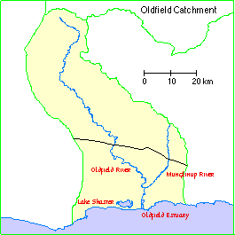
Oldfield catchment |
|
Overview
|
 |
Waterways
|
The Oldfield catchment comprises the Oldfield Estuary and Lake Shaster together with the catchments of the Oldfield and Munglinup Rivers and their tributaries plus some the small creeks, drains and land which drains to the estuary. The town of Munglinup is within the catchment area.
Climate
This is a fairly low rainfall area, with most rain in winter. Infrequent unseasonal heavy rain can occur, and floods can be as important to the future of the estuary as the winter rains because of the erosion they cause and the sediment they carry. Daily maximum temperatures are at their highest in January (averaging 28°C) and lowest in July (16°C). Daily minimum temperatures in the same months are 14°C and 7°C respectively.
Soils and landforms
The catchment rises gradually from behind the coastal dunes to some 250-300 metres at the northern watershed on the south edge of the plateau. The topography is mainly that of rounded and shallow valleys in the northern section and deeper valleys in the south. At the coast a chain of rocky headlands is linked by dunes.
Shallow loamy soils overlie yellow clayey subsoils in the upper part of the catchment. The soils are saline.
In the southern part you find predominantly sandy duplex soils, usually with ironstone gravels within the sandy topsoil.
Flora and Fauna
The Oldfield and Munglinup Rivers provide important vegetated corridors, linking the coastal strip with the large tracts of natural bushland in the upper reaches of the catchment.
A mosaic of dense scrubland and sand heath dominates the coastal dune system and coastal plain. The dense scrub to three metres high is mainly a mixture of small Eucalypts and Acacia, with a Melaleuca dominated understorey. Most of the northern catchment is uncleared, and carries Eucalyptus and Melaleuca. Large patches of broombush thickets are scattered over the catchment, consisting of Casuarina and Melaleuca.
Around half of the Oldfield River catchment is the Mallee District, characterised by:
Mammals known to occur on the sandplain include the Honey Possum, Pygmy Possum, Southern Bush Rat, Common Dunnart, Echidna, Grey Kangaroo, and the Western Brush Wallaby. The Southern Brown Bandicoot has also been recorded in a number of areas along the coast.
Emus are found in the region, and eighteen species of water birds have been recorded at the estuary.
Land use
The upper part of the catchment is in the eroded bush country of mining reserves. There are some small nature reserves along the rivers. Much of the lower part of the catchment has been cleared for agriculture, while the northern half of the catchment remains naturally vegetated Crown land.
Nearly all agricultural properties have sheep, and half of the locations run cattle. Approximately 60% of cleared land is in pasture, and around 25% is sown to cereals, mainly wheat and barley.
Approximatley 20% of farmland in the catchment remains as remnant bush, a fair proportion of which is in good-excellent condition. On farmland, 65% of remnant vegetation has been fenced off from stock.
Water Resources Assessment and Enhancement Project
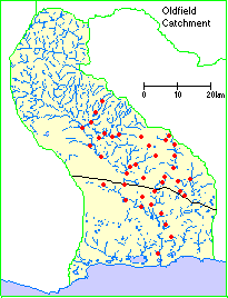
The Water Resources Assessment and Enhancement Project includes a component to assess environmental water quality within estuaries and catchments on the south coast, including waterways in the Oldfield catchment. The local coordinator was appointed in May 1998. A total of 48 sampling sites were proposed, distributed over the main channels of the Oldfield and Munglinup Rivers as well as on tributaries.
Location of water quality monitoring sites:
Preliminary results cover the period from May to August 1998. Figures collected for total nitrogen and total phosphorus relate to periods when streams were flowing. Higher values were detected in "no flow" stream pools.
| Streams not flowing | Streams flowing | All conditions | ||
| Total Nitrogen (mg/l) | Minimum | 0.52 | 0.46 | 0.46 |
| Maximum | 8.90 | 2.50 | 8.90 | |
| Total Phosphorus (mg.l) | Minimum | 0.01 | 0.01 | 0.01 |
| Maximum | 1.50 | 0.52 | 1.50 | |
| Salinity (mS/cm) | Minimum | 0.10 | 16.75 | 0.10 |
| Maximum | 193 | 99.25 | 193 | |
| Average | 42.6 | 43.8 | 43.1 |
Acceptable values for water quality for south coast streams, under various conditions, are not currently available. The Australian Water Quality Guidelines for Fresh and Marine Waters 1992 show upper limits above which water quality problems have been known to occur. These are
Total Nitrogen: 0.1 - 0.75 mg/litre
Total Phosphorus: 0.01 - 0.1 mg/litre
Salinity values in the preliminary data appeared to vary considerably across the catchment but with the higher values predominantly in the upper agricultural area. Relatively fresh water was found at times in various tributaries spanning the upper to the lower end of the catchment, no doubt a result of recent rainfall.
This preliminary data suggests that the Oldfield catchment has a diverse range of aquatic environmental conditions. Observations and measurements indicate that the water quality and waterways systems in general are still in reasonable condition, however high values of nutrients in various locations are cause for concern. The continued development of water quality assessment methods will complement other stream, estuary and wetlands information to provide adequate management resources for communities to use into the next century.
Wetlands Surveys
The following wetlands in the catchment have been surveyed and "report cards" prepared. The reports are available as PDF files. The locations of the wetlands can be seen on the survey map and in the overall survey report.
