|
Oldfield Estuary |
| Oldfield Estuary at a glance | |||
| Estuary length: | 3 kilometres |
||
| Average annual catchment rainfall: | 400 mm | ||
| Estuary area: | 1 sq kilometre | ||
| Annual flow into Oldfield Estuary: | 2.3M cubic metres | ||
| Estuary health: | highly saline | ||
| Data selection | |||
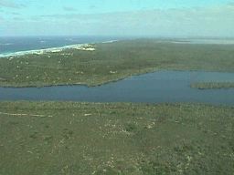
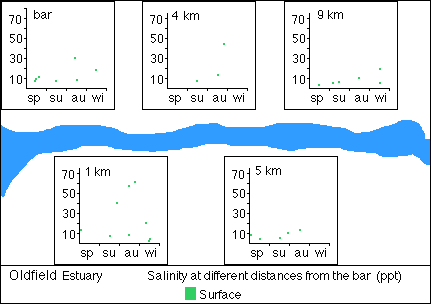
The narrow lagoon has been filled from both ends with river sediment and beach sand. Although it is up to five metres deep, it has extensive shallow areas which often dry out. The mouth of the estuary is 200 metres wide and until recently may have been much wider. The long, high bar breaks every 3-4 years after heavy rain falls in the catchment and only stays open briefly. The bar broke in January 1999 following rainfall in excess of 150 millimetres in the catchment. When the bar breaks, little water may remain by the end of summer, and what there is becomes brine.
The estuary is vested with the Shires of Ravesnthorpe on the west and Esperance on the east. The riverine reaches of the estuary are joinly vested as Park Reserve by both shires. The Lake Shaster Nature Reserve, vested with the Department of Conservation and Land Management, lies either side of the Oldfield Estuary Reserves. The estuary provides an important link between the coastal strip and the Oldfield and Munglinup Rivers which provide vegetated corridors to the large tracts of natural bushland in the upper reaches of the catchment.
A detailed vegetation survey was completed in January 1999 by a consultant on behalf of the Oldfield Catchment Group, the Water and Rivers Commission and the Shires of Esperance and Ravensthorpe. The survey recorded the condition of the vegetation adjacent to the Oldfield Estuary and the presence of exotic weed species. The survey identified forteen vegetation communities, with at leeast 110 native species identified. Generally the vegetation condition of these vegetation communities was pristine (A1) condition to slightly disturbed (A2-3). Weed invasion was obvious in the upper third of the estuary.
The often prolonged closure of the bar, the shallow water and the variable salinity of the water limits the estuary's potential as a fish habitat.
The only available temperature records range from 22.8 degrees C. to 13.8 degrees C. at the surface, but a temperature of about 12 degrees C. must be expected in winter to about 25 degrees C. in summer, or more in shallow water.
Surface water can be expected to be saturated or supersaturated with oxygen, but there is likely to be some deoxygenation of deeper water, if it is stratified.
There is no evidence of pollution of the estuary.
 |
 |
 |
|
Further Information:
Ernest P. Hodgkin and Ruth Clark: Estuaries and Coastal Lagoons of South Western Australia: Stokes Inlet, Oldfield Estuary and Ten Others. Environmental Protection Authority, Perth, Western Australia: Estuarine Studies Series No. 5 June 1989.
South Coast Regional Land and Water Care Strategy: The Esperance-Sandplain Sub-region. Prepared by: the South Coast Regional Assessment Panel and the South Coast Regional Initiative Planning Team, February 1997.
Oldfield Catchment 1998. Report prepared for the Oldfield Landcare Group