|
Oldfield River |
| Oldfield River at a glance | |||
| Catchment area: | 2479 square kilometres |
||
| Average annual catchment rainfall: | 355 millimetres | ||
| River length: | 95 kilometres | ||
| Annual discharge into Oldfield Estuary: | 6900 Megalitres | ||
| Percentage cleared: | 35% | ||
| River health: | highly saline | ||
| Water quality: | See report | ||
| Data selection | |||
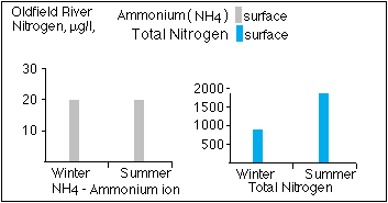
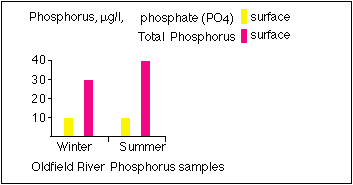
River flow is highly variable and dry years may be negligible. Some permanent river pools up to 500 metres long are maintained by springs - they represent very important habitats. It is some concern that they are being degraded through the effects of eutrophication. River degradation, especially the loss of riparian vegetation, sedimentation and eutrophication of river pools has resulted from clearing.
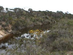
The Oldfield River flows to the Oldfield Estuary, which flows to the ocean when the sandbar is breached during high rainfall events. This generally happens once or twice a decade during heavy rainfall or exceptionally wet winters.
The Oldfield River is naturally saline, although salinity levels are thought to be elevated through extensive clearing in the catchments, which has also caused an increased amount of sediment to be washed from the highly erosive sandy soils, filling river pools and clogging channels.
In 2005 a project (Our Living Rivers) was set up to collect and analyse data, enabling the Department of Water to monitor the health of the river over time and help determine what systems need better protection. In spring 2006 and 2007 samples were taken from the river system to assess the quality of the water and habitat as well as the presence of fish and macroinvertebrates. Seven sites were sampled on the Oldfield River.
 |
 |
 |
|
Further Information:
Ernest P. Hodgkin and Ruth Clark: Estuaries and Coastal Lagoons of South Western Australia: Stokes Inlet, Oldfield Estuary and Ten Others. Environmental Protection Authority, Perth, Western Australia: Estuarine Studies Series No. 5 June 1989.
South Coast Regional Land and Water Care Strategy: The Esperance-Sandplain Sub-region. Prepared by: the South Coast Regional Assessment Panel and the South Coast Regional Initiative Planning Team, February 1997.
Oldfield Catchment 1998. Report prepared for the Oldfield Landcare Group