|
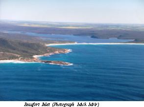
Beaufort Inlet |
| Beaufort Inlet at a glance | ||||
| Average annual catchment rainfall: | 600 millimetres | |||
| Inlet area: | seven square kilometres | |||
| Inlet volume: | 6.5M cubic metres | |||
| Data selection | ||||
Beaufort Inlet lies in a roughly southeast alignment, and has long, winding riverine reaches through narrow valleys cut into the soft spongolite rock, which is exposed in cliffs and steep slopes on the banks. The Pallinup River has cut down to the hard basement granitic rock that underlies the spongolite. The mouth of the inlet is connected to the sea by a sand bar.
The estuary has considerable habitat value due to the extensive fringing vegetation and wading bird habitat. The Inlet is home for many aquatic flora and fauna, including marine fish and invertebrates which enter when the bar is open. The Inlet also supports both tourism industries and commercial fishing operations with catches between the years 1992 to 1996/97 estimated between 1800 kilograms and 2400 kilograms a year.
Beaufort Inlet is significant to Aboriginal people before European settlement and now supports a wide range of recreational activities including fishing and camping.
The estuary is 14 kilometres long, with the upper eight kilometres riverine, in a deep river valley incised through the spongolite rock to the granitic bedrock. The estuary has an area of seven square kilometres, and an estimated volume of 6.5 million cubic metres (below mean sea level).
Beaufort Inlet has a high bar, which opens periodically to the sea at intervals of several years. The bar is about 500 metres long. The opening and closing dates of the bar have been recorded since 1954.
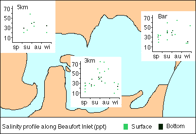
The water in Beaufort Inlet is seldom clear. The turbidity is caused mainly by the abundant plant plankton and by fine sediment resuspended by wave action. The salinity in Beaufort Inlet varies from one third to about twice that of seawater. The salinity is seldom less than 18 ppt (half that of seawater which is 36 ppt) following river flow. Evaporation may raise salinity to 50 - 60 ppt before the winter rains. The temperature of the Inlet varies from approximately 12 degrees in winter to 25 degrees in summer.
State of Beaufort Inlet
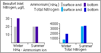
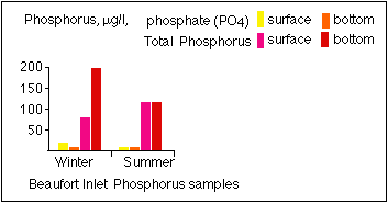
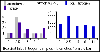
Beaufort Inlet is seriously eutrophic, a condition that probably results from the heavy use of superphosphate fertilizer in the catchment of the Pallinup River. Nutrient pollution is widespread, a consequence of the heavy fertilising of the sandy soils. Fish kills in estuaries are a natural event, however these have been happening more regularly and more extensively. Toxic phytoplankton has also been identified in warmer summer months. There is also increased pressure from tourists and concerns regarding commercial fishing.
The Department of Environment has been monitoring Beaufort Inlet since 1997. The monitoring results indicate moderate to high nutrient levels. This is indicative of potential degradation of the water quality due to excessive plant growth and succession of ecologically harmful species. Excessive macroalgae and seagrass growth has been reported for Beaufort Inlets in addition to reports of dinoflagellate blooms in Beaufort Inlet.
The deoxygenated waters in the shallow parts of the Inlets in Beaufort Inlet are of concern and are a symptom of eutrophication stress, due to high organic loads. Severely deoxygenated waters can lead to internal nutrient release, so increasing the nutrient loads in the water column and leading to further degradation of the waterbody.
The Beaufort has been sampled for phytoplankton since 1997 and high levels of picoplankton were recorded. In March 1998 there was a significant bloom of phytoplankton especially the dinoflagellates and diatoms.
By June 1998 a fish kill occurred and there was a bloom of dinoflagellates especially the small Heterocapsa and a potentially ichthyotoxic species Gyrodinium. The water was green due to a significant amount of picoplankton cyanobacteria cf. Synnechococcus. No Prymnesium species were detected during the fish kill however. A steady amount of runoff broke the bar in June 1998 and there was flushing event which helped to reduce phytoplankton levels to a lower level.
Sediment of Beafort Inlet is also a major concern. Following the flood in January 1982, an estimated 100,000 tonnes of sediment was carried down the Pallinup and deposited in Beaufort Inlet.
With increasing fish kill events, toxic algae blooms and pressure to open the bar artificially - the community requested more information on the health of the estuary. To help understand the inlet's condition and better manage the estuary, the Wellstead LCDC and the Water and Rivers Commission submitted a Coastcare Application 1998-2001. The information on water quality is indicating that Beaufort Inlet is showing signs of nutrient enrichment. The grant also paid for the collection of historical information on the estuary, published in "Stories of the Beaufort Inlet". For more information, contact the Department of Environment.
Water Quality
The inlet is relatively shallow, with high evaporation. A noticeable feature of the lagoon water is that it is seldom clear. The turbidity is caused mainly by the abundant plant plankton and by fine sediment resuspended by wave action in the shallow water.
Less obvious, but equally important for the life in the estuary, is the extreme range of salinity experienced. Salinity varies from one third to about twice that of sea water, making it an unfavourable environment for most marine animals and plants. Marine fish and invertebrates enter when the bar opens, but most do not survive long in the high salinity and there can be catastrophic mortality of the fauna.
Water temperature probably varies from about 12 degrees C. in winter to 25 degrees C. in summer. There may be some stratification in the deeper water of the riverine part of the inlet when the bar is open, and there may be a temperature gradient along the estuary. The few available records indicate that oxygen concentration is generally high in the lagoon.
The sea bar usually opens for just a few weeks, following unusually heavy rain, and may remain closed for several years. The mouth of the inlet is constricted by dunes, and the high bar creates a dam; the water level varies greatly between flood and late summer conditions.
The Beaufort Inlet is undergoing eutrophic changes. The Beaufort Inlet has high levels of nutrients and chlorophyll 'a', an indicator of algal growth and has had blooms of green algae and fish deaths due to deoxygenation. High nutrient levels have been recorded - the highest for any estuary on the south coast sampled so far. These nutrients are believed to have come from fertilizers applied to the catchment soils. There is no evidence of pollutants other than nutrients entering the estuary.
 |
 |
 |
|
 |
|
 |
|
Further Information:
Hodgkin, E.P. and Clarke, R. (1988) An Inventory of Information on the Estuaries and Coastal Lagoons of South Western Australia. Estuaries of the Shire of Jerramungup. Environmental Protection Authority, WA. Estuarine Studies Series 4.