|
Jerdacuttup River |
| Jerdacuttup River at a glance | |||
| Catchment area: | 1818 square kilometres |
||
| Average annual rainfall over catchment: | 430 millimetres | ||
| River length: | 65 kilometres | ||
| Annual discharge volume into Jerdacuttup Lakes: | 4400 Megalitres | ||
| Percentage cleared: | 50% | ||
| River health: | saline | ||
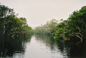
Flow of the Jerdacuttup River is seasonal due to sparse rainfall and absence of significant aquifers to sustain baseflow. The water in the river is saline.
In 2005 a project (Our Living Rivers) was set up to collect and analyse data, enabling the Department of Water to monitor the health of the river over time and help determine what systems need better protection. In spring 2006 and 2007 samples were taken from the river system to assess the quality of the water and habitat as well as the presence of fish and macroinvertebrates. Four sites were sampled on the Jerdacuttup River.
Further Information:
South Coast Regional Land and Water Care Strategy: The Fitzgerald-Biosphere Sub-region. Prepared by: the South Coast Regional Assessment Panel and the South Coast Regional Initiative Planning Team March 1997.