
|
Phillips - West catchment |
| Overview | 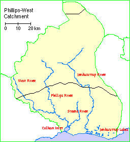 |
Waterways |
Description
The Phillips-West catchment comprises Jerdacuttup Lakes together with the catchments of the Phillips, West and Jerdacuttup Rivers and their tributaries plus some of the small creeks, drains and land which drains to the lakes.
Most of the information presented here relates to a more restricted site, comprising Culham Inlet and the adjoining lower (permanent) reaches of the Phillips River and Steere Rivers.
Nearby wetlands: The Hamersley River system is 13 kilometres west, the Fitzgerald Inlet System (ESP003WA) is 40 kilometres south-west, and the Jerdacuttup River system is 12 kilometres east.
Landform: Macroscale ovoid lake, microscale sinuous rivers; also some microscale irregular sumpland beside the south-west and north of the lake and at the river mouths.
Poor drainage of the area has resulted in rain-borne salt accumulating in deep soil profiles. Clearing of the native vegetation has caused groundwater levels to rise and mobilise these salts.
Geological setting: Situated in the Yilgarn Craton (Bremer Basin), at the interface of schist/quartzite uplands to the west, culminating in Eyre Range and East Mount Barren (to 300 metres), and undulating lowlands overlying gneiss to the east.
Near Ravensthorpe there is a very old Greenstone Belt which runs through the Archaean granites and gneisses. This is the main area of mineralisation in the sub-region.
There is a wide variety of soil types in the sub-region:
Climate: Rainfall is relatively low, decreasing from around 500-600 mm on the coast to 360 mm in the upper catchment. Median and mean annual rainfall at Hopetoun are 503 mm and 506 mm respectively, mostly falling in May-August, with significant summer rain in many years; annual evaporation is about 1900 mm.
Compared to the west coast, this area has a more uniform rainfall distribution, relatively fewer hot winds, and more cloud cover, with low risk of frost.
Water supply: Phillips River originates 65 kilometres north north-west (its tributary West River 55 kilometres north-west) and uppermost parts of its catchment are cleared, lower parts uncleared. Steere River originates 25 kilometres north and most of its catchment is cleared. Several creeks originate 3-8 kilometres west in the ranges. The inlet is separated from the Southern Ocean by a bar of dunes 30- 40 metres wide, 4-5 metres high, which broke naturally in 1849 and May 1993 (for three to four weeks). The inlet therefore is no longer truly estuarine.
Inundation: Inlet and rivers permanent; marshes seasonal. In 1988-9, some eucalypt and melaleuca forest/scrub fringing the inlet was inundated for several months.
Water depth: The inlet is deepest near the bar and may hold water to two metres deep for several years but usually is shallow, almost drying up at times. It was 4.5 metres deep in August 1989 following exceptional rains in May 1988 and winter 1989 (also further flooding in 1992); water seeped through the bar to the ocean during this period.
Water salinity: The rivers and creeks are naturally saline (e.g. Phillips 10 ppt, Steere 5 ppt when flowing), creeks off the ranges less so; salinities of the rivers have increased since land clearance. Minimum recorded salinity in the inlet in the 1980s was 17 ppt in September 1989; the inlet becomes briny while drying up.
Ecological role: At times a major dry season refuge for the Banded Stilt Cladorhynchus leucocephalus.
Plant structural formations: Low shrubland (samphire) occurs in the marshes; areas surrounding the system support low open-forest and open-scrub, to the river edges.
A good example of a closed estuary and inflowing saline rivers (lower reaches).
Notable flora:
Threatened Species: None.Composition: Species typical of samphire marshes of the south coast of the bioregion probably occur in the marshes.
General Comments: Tallerack mallee heath and Banksia scrub heath occur extensively on the sandy plains. The heavier gravel and clay soils and breakaways support swamp yate, moort or mallet woodlands, mallee or mallee heath. The shallow loams overlying granites of the Yilgarn Craton support Swamp Yate woodland, Sheoak woodland and broombush thicket. Seasonally wet depressions in clay soils are widespread and support tall woodlands of Swamp Yate.
The Fitzgerald River National Park provides an exceptional area of plant diversity, accounting for some 20% of WA's described vascular flora. The Fitzgerald area is recognised as one of three nodes of species richness in the state.
The major plant families represented in the Fitzgerald area are Myrtaceae, Proteaceae, Asteraceae and Cyperaceae.
Notable fauna (waterbirds):
Threatened Species: None.Composition: 31 species recorded, eight listed under treaties; mostly ducks and allies and shorebirds.
Breeding: No breeding confirmed. More than 30 Great Egret (Egretta alba) in full breeding colours were observed feeding (on fish) at several parts of the site during spring 1988; an active breeding colony was almost certainly nearby, either within the system or 13 kilometres east south-east near Jerdacuttup Lakes.
Moulting: The inlet is probably used for moulting by Australian Shelducks; more than 1000 were present in November of 1988, 1990 and 1991.
Migration Stop-over: When shallow, the inlet is used by at least six species of migrant shorebirds, e.g. Red-necked Stint (up to 500). Further systematic surveys may prove the site to be a significant stop-over area.
Numbers: The estimate (by extrapolation) of 44 000 Banded Stilts on the inlet in October 1986 is more than 1% of the national population and in the 1980s was exceeded at only four other sites in Australia, only one of them in WA; thousands have also been recorded on other occasions. It is also the third highest waterbird total for a site in south-western Australia. The highest number of waterfowl counted was 10 476 in March 1991; more than 1000 waterfowl often occur, e.g. 1988, 1990. 1991. The most abundant waterbird species at the site are Banded Stilt, Eurasian Coot (up to 9307, March 1991; regional rank 4) and Australian Shelduck (4650, November 1990).
Notable fauna (other taxa):
Threatened Species: None.Composition: A limited variety of fishes, including species of Bream, Hardyhead and Goby, occurs when salinity is favourable. Shells of the marine mollusc Katelysia scalarina occur in the inlet sediments, indicating former tidal regime.
The Fitzgerald River National Park is rich in vertebrate fauna, supporting more species than any other conservation reserve in the South West. The richest area for mammal and reptile species is the uplands, with the inlets, rivers, swamps and lakes providing for the greatest diversity of bird species.
Social and cultural values:
Research: Some research by RAOU/WADCALM (nine surveys of waterbirds/waterfowl, 1986-91).Economic: Some commercial fishing occurs in the Phillips River within the national park.
Aesthetics: The broad waters of the inlet immediately adjacent to the steep, uncleared slopes and rugged peaks of East Mount Barren and the Southern Ocean, provide an aesthetically outstanding landscape. The unspoilt lower reaches of the Phillips River are navigable and very scenic.
Land tenure and land Use
Land tenure:
On site: Culham Inlet is classified as marine waters, Phillips River is within the Fitzgerald River National Park and Steere River is in vacant crown land.Surrounding area: Fitzgerald River National Park to the west. Reserves 34998 (recreation) and 17589 (water) and freehold land to the east.
Current land use :
On site: Culham Inlet: None; Phillips River: Nature conservation and some commercial fishing.Explorers and botanists preceded settlers. The discovery of brown coal in the Fitzgerald valley prompted more settlers, and pastoral and sheep grazing formed the basis for most settlement. Gold was discovered on the Phillips River at the end of the 1800s, with the mining smelters finally closing in 1918.
The district is not suitable for cropping, although superphosphate was used successfully. Post World War Two settlement was encouraged by the government, with wheat, oats and barley being grown. Farming spread in the late 1960s, with grain, sheep and cattle.
Current uses are wool, sheep, wheat, barley, oats, lupines, field peas, beef, fat lambs, emus, deer, fish, mining and wildflowers.
Surrounding area: Nature conservation, recreation, cereal cropping, pasture grazing and low-moderate human population, mostly at Hopetoun. The site has a buffer of native vegetation more than one kilometre wide on the west side.
Conservation
Current threats: Further salinisation of inflow rivers, eutrophication (agricultural fertilisers), siltation (increasing).
Potential threats: Pollution from possible mining in the catchment.
Conservation measures taken: The Fitzgerald River national park is a UNESCO Man and Biosphere Reserve and the inlet falls within the surrounding zone of co-operation. The national park is listed on the Register of the National Estate.
Management authority and jurisdiction: The park is managed by WADCALM for NPNCA. The district office is located at Esperance.
Wetlands Surveys
The following wetlands in the catchment have been surveyed and "report cards" prepared. The reports are available as PDF files. The locations of the wetlands can be seen on the survey map and in the overall survey report.
Management Reports
Management recommendations:
in Jerdacuttup River Action Plan (2002) Water and Rivers Commission
in Phillips River Action Plan WRM 40 (2003) Department of Environment
Foreshore survey:
in The Steere River and its tribuaries - an accessment of condition and values (2007) Andy Chapman
in West River Condition Report (2004) Andy Chapman
Copies of these reports are available from the Albany office of the Department of Water.
