|
Shannon River |
| Shannon River at a glance |
|
||||
| Location: | 19 kilometres west of Walpole |
||||
| Catchment area: | 1000 square kilometres |
||||
| Average annual catchment rainfall: | 1350 millimetres | ||||
| River length: | 65 kilometres | ||||
| Annual discharge volume into inlet: | 157M cubic metres | ||||
| Extent of tidal influence: | Three kilometers | ||||
| River health: | good - no salinity problems | ||||
 The wetland system is important to the survival of migratory birds, supports large numbers of waterbirds and is an excellent example of a south coast wetland. These wetlands are under threat from rising water tables, salinity and other issues as a result of land management practices in the upper catchment.
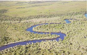
Sandbanks bar the mouth of the river, where it enters Broke Inlet. The river channels are deep, from three metres on straight areas up to ten metres where it is scoured on a bend. The inlet channel is up to six metres deep, with steep slopes on either side.
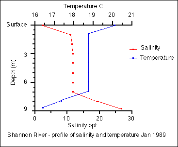
In summer, when the river flow is slight and the bar is open, high salinity water flows from the lagoon into the Shannon River under the river water, causing strong stratification. This corresponds strongly with the temperature profile of the water at the same date.
Some oxygen depletion (3.7 mg/litre) has been recorded in the deeper waters of the river.
In 2005 a project (Our Living Rivers) was set up to collect and analyse data, enabling the Department of Water to monitor the health of the river over time and help determine what systems need better protection. In spring 2006 and 2007 samples were taken from the river system to assess the quality of the water and habitat as well as the presence of fish and macroinvertebrates. Five sites were sampled in the Shannon River catchment.
Further Information:
Estuaries and Coastal Lagoons of South Western Australia. Broke Inlet and other estuaries of the Shire of Manjimup. Environmental Protection Authority; Perth, Western Australia. Estuarine Studies Series Number 6: September 1989