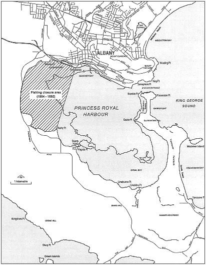
Figure 3-7: Princess Royal Harbour
Princess Royal Harbour
Princess Royal Harbour is a roughly oval-shaped, land-locked bay located to the south of the town of Albany. The harbour is 8 km long and 4 km wide, orientated in a north-west-south-east direction. The total area of the harbour is about 29 km2. It is made up of a deep basin bordered by a shallow sand flat.
About half of the harbour is less than two metres deep. Most of the shallow sand flats are on the western and southern shores. No major rivers flow into Princess Royal Harbour. Freshwater going into the harbour comes from local run off, drainage channels and rain.
The entrance to the harbour from King George Sound is a narrow channel on the eastern side of the harbour. A dredged channel (12.2 metres deep and 180 metres wide) goes through the entrance and continues about two kilometres into King George Sound. This channel is dredged to let ships get into the Port of Albany. The Port of Albany is east of the centre of Albany town. The port is three land-backed berths 608 metres long. There are plans to expand in the near future.
| For more about water stratification and flushing rates see section 2.1 - Estuarine Characteristics |
The movement of water within the harbour itself and between the harbour and King George Sound varies with the season. However, a typical flushing time is about 20 days.
The two harbours have many different types of biota (living things) and some of the places they live need protection. The mudflats of Princess Royal Harbour have large populations of migratory wading birds. The shallows on the eastern shores of the harbour are good roosting areas when strong winds blow in late summer. This area is relatively secluded and the birds aren't disturbed very much. In contrast, another important habitat is located at Rushy Point on the south-western shore of the harbour. This wading birds habitat can be disturbed by trail bikes and off-road vehicles.
The western end of Princess Royal Harbour also has a lot of mudflats which are an important fish habitat and breeding area. Many cobbler nests can be seen in the harbour sediments at low tide. This area was closed to fishing from 1984 until mid-1992 owing to toxic contamination in the sediments, animals and plants. The shallows near the eastern shore of the harbour are important habitat and breeding areas for young fish.
There is a modest amount of fringing vegetation still undisturbed, mostly along the south-eastern and north-western shores.
Vancouver Peninsula stretches along the eastern edge of the harbour and protects much of its waters from the exposed King George Sound and Southern Ocean. The Peninsula is a tombol linking two granite outcrops. It dominants the landscape. Frenchman Bay is on the King George Sound side of Vancouver Peninsula. It is an important recreational area for the Albany region. A large recreation reserve also covers most of Vancouver Peninsula. Land subdivision for houses is occurring on the Frenchman Bay side of the Peninsula. More and more people are using the foreshore next to this subdivision.
Torndirrup National Park stretches along the coast to the south of the harbour. The park is managed by the Department of Conservation and Land Management (CALM) according to interim management guidelines. The park's large expanse of natural vegetation is an important conservation area: a refuge for animals and plants. From the town of Albany it is an attractive backdrop to the harbour.
Figure 3-7: Princess Royal Harbour
The southern and western shores of Princess Royal Harbour and an area that extends south to the coast are the Albany Groundwater Area, declared so under the Rights in Water and Irrigation Act 1914. This Act allowed the Water Corporation to give licences to people to allow them to draw water from underground in the area. This licencing is aimed at controlling how much water is taken from the groundwater supplies. A large proportion of this groundwater area is also proclaimed as the South Coast Water Reserve under the Country Areas Water Supply Act 1947. It is reserved to protect groundwater quality and so within these areas landuses are carefully managed. The reserve, which supplies most of Albany's drinking water, was also managed by the Water Corporation but is now the responsibility of the Water and Rivers Commission, along with the groundwater licensing.
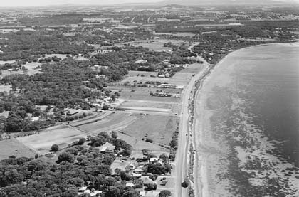
Western edge of Princess Royal Harbour: Cleared for vegetable growing and beef farming
Limeburners Creek enters the harbour on its southern shore. The creek flows through the area where rainwater seeps into the ground and recharges the underground water supplies. This area is part of the South Coast Water Reserve. A large reserve managed by the Water and Rivers Commission covers the place where this creek flows into the harbour. Foreshore vegetation has been retained in this area and public access is restricted.
Land to the west of Limeburners Creek has been subdivided and is zoned residential. The major residential area at Little Grove is expanding but is currently unsewered. Septic tanks could be a problem for water quality in the harbour. Nutrients from septic tanks may be carried by groundwater into the harbour waters. This could increase the nutrient problems in both harbours.
Little Grove also has the only sailing club in the Albany area. The club is popular and used more and more for events. There's a public car park and boat launching ramp south of the club.
| For more about polution in the harbours see section 4.5 |
The Town of Albany is located on the northern shore of Princess Royal Harbour. The natural harbour was the main reason for the town's establishment. Much of the town is hilly and there are outstanding views over the harbour and King George Sound. There are many granite outcrops, including Mount Elphinstone, Mount Melville and Mount Clarence. Much of the town's stormwater enters the harbour on the northern shore.
The Port of Albany is east of the main townsite. The port has three land-backed berths 608 m long. Products such as wheat, barley, oats, lupins and silica sand are exported and fertilisers and petroleum products imported. In 1997 the port handled 2.3 million tonnes. This is expected to increase to more than 6 million in the next decade. Spillage during unloading can affect the water quality of the harbour. The port is taking steps to reduce any harm.