|
Lake Gore |
| Lake Gore at a glance | |||
| Location: | 34 kilometres west of Esperance |
||
| Area: | 740 hectares | ||
The data presented here relates to Lake Gore and adjacent/interconnected satellite lakes, each wetland to the maximum high water mark. Named satellite lakes are Carbul, Kubitch and Gidong Lakes to the west and Quallilup Lake to the south; about ten unnamed smaller lakes and a large swamp connecting Lakes Gore and Quallilup (here named "Overflow Swamp") are included.
Nearby wetlands: Mortijinup Lake System (ESP006WA) is 3.5 km east; the Southern Ocean is 1 kilometre south of Quallilup Lake.
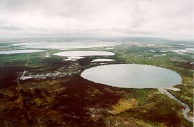
Lake Gore, a large open, near-permanent lake (738 ha.) is located within Nature Reserve 32 419 (792 ha.), that set aside for conservation. Lake Gore is considered nationally significant and is listed in the 1996 Environment Australia publication 'Directory of Important Wetlands in Australia' (Lane et al, 1996). Lake Gore and the surrounding lake system consisting of Lakes Carbul, Kubitch, Gidong, Quallilup and Overflow Swamp have been accepted as an 'Internationally significant Wetland' under the RAMSAR convention (Jaensch, unpublished).
Downstream is a system of inter-connected smaller lakes (Lakes Gidong, Kubitch, and Carbul), swamps and creeks ('the Overflow Wetlands') all of which are natural wetlands. Some of the wetlands occur on private property. Nearer to the coast is Quallilup Lake, which is located in a near-closed valley in the calcareous coastal range (to 80 m elevation) that separates the plain from the Southern Ocean.
Lake Gore and many of the overflow wetlands support a generally narrow zone of open-woodland consisting of saltwater paperbark, Melaleuca cuticularis with an understorey of the sedges Gahnia trifida and Schoenus brevifolius at or near the margins. Areas of low shrubland dominated by samphires, Suaeda australis and Sarcocornia quinqueflora, the grass Sporobolus virginicus and the herb Samolus repens, occur in the overflow wetlands. After extremely wet years, fringing woodland vegetation may be fully inundated. Surrounding areas support mainly open-scrub or open-heathland, or are cleared.
Most of the shoreline of Lake Gore has a buffer zone of less than 50 m within the nature reserve's protected areas. The beaches of Lake Gore have red shell deposits of a small invertebrate that thrives in the lake. Some shells collected at Lake Gore were identified as a Coxiella species, probably Coxiela exposita. Coxiella can tolerate a wide variation in salinity, from very low to hypersaline, and are usually the only mollusc present in a habitat or are the outstanding dominant species.
Lake Gore is a sub-terminal drainage basin. It is seasonal or near permanent, sometimes being nearly dry in autumn. It is a fairly shallow lake, with a maximum depth of 2 m. Water flow is derived from a relatively large surface catchment (much of it cleared of native vegetation) and transported via mainly the Dalyup River and minor seasonal streams. When Lake Gore completely fills, it spills over and flows via the Overflow Swamp to Quallilup Lake.
The Coobidge Creek system flows into Carbul, Kubitch and Gidong Lakes. In exceptionally wet years the overflow of both systems may merge and flow via an ill-defined watercourse, westwards from Overflow Swamp, some 12 km. west to Barkers Inlet and the Ocean.
The lake is situated in the Albany-Fraser Orogen, in alluvial/lacustrine sediments overlying marine limestone and gneiss/sandstone on a sub-coastal plain. Small, bare rock outcrops occur in Lake Gore and Kubitch Lake.
The wetlands are good example of a system of saline coastal lakes of varied depth and salinity, which at times has extensive associated brackish / saline marshes. Salinity levels in Lake Gore range from saturated salt (eg. January 1984, when less than 0.5 m deep) to 6.5 parts per thousand (September 1989) with a September mean of 52.1 ppt (n=12). Water pH ranges from 7.1 to 9.4 and is colourless. The overflow wetlands mainly hold water when the lake has overflowed and are therefore at the lower end of salinities recorded for Lake Gore. Water in Lake Gore is monitored by scientists from CALM Woodvale Research and as part of the CALM / Esperance Senior High Schools 'Ribbon of Blue' project.
Its importance to the conservation estate (particularly for waterbirds) is well known and has recently been selected as a RAMSAR listed 'Wetland of International Importance'. Evidence suggests that Lake Gore regularly supports in excess of 20 000 individual waterbirds each year (up to 29,000 waterbirds have been counted).
Potential significant long-term threats to the wetland system include eutrophication, sedimentation and salinisation. Major algal blooms, probably due to use of agricultural fertilisers in the Dalyup River catchment, have occurred in Lake Gore from time to time and result in deposits of algal mats on the shores. The impact of these blooms/mats on waterbirds including Hooded Plover is not known. Dead trees in the paperbark woodlands are also indicative of prolonged inundation, caused by an increased inflow to the lake following wet years.
Lake Gore and the surrounding wetland system ranks in the top 1% of wetlands in South West WA (602 surveyed) for numbers of individual waterbirds (Raines, unpublished). Over 20,000 birds a year have been recorded at Lake Gore (Jaensch et.al, 1988). A total of 54 different waterbird species have been recorded on the Lake Gore Wetland System, of these twelve have been recorded breeding.
The highest numbers of Hooded Plover (Charadrius cucullatus) and the second highest numbers of Banded Stilt (Cladorhynchus leucocephalus) and Common Sandpiper (Tringa hypoleucos) have been recorded on Lake Gore. Up to 12,000 Australian Shelducks (Tadorna tadornoides) have gathered on Lake Gore because of its desirability as a moulting area for the ducks (Halse et al., 1993). The lake is also significant for the Greenshank (Tringa nebularia) and Sanderling (Calidris alba). Lake Gore is a preferred drought refuge for waterbirds such as the Banded Stilt (Cladorhynchus leucocephalus) and Hooded Plover (Charadrius rubricollis) (Halse et al., 1993).
The Lake Gore wetland system is considered to be of international importance and has recently been listed as a RAMSAR 'Wetland of International Importance' (Klaus Tiedemann, pers. comm., 2000).
The Japan-Australian Migratory Bird Agreement (JAMBA) and the China-Australia Migratory Bird Agreement (CAMBA) are international treaties that have been signed by the Australian Government. These treaties list certain bird species that the Australian government and community are obliged to conserve and enhance the survival rates. Seventeen birds that occur on the JAMBA treaty and sixteen birds that occur on the CAMBA treaty have been found on the Lake Gore Wetland System (Jaensch, 1988).
Many of the waterbirds' main food source is brine shrimp and a Coxiella species (a small pink cone-shaped gastropod) that are found in the lakes.
In January 1995, 1600 Hooded Plovers were recorded on Lake Gore. Its population, estimated at 5000, is classed by IUCN as 'Rare' (Jaensch, 1988). This represents 32% of the estimated world population. The Hooded Plover is also listed under Schedule 2 of the Wildlife Protection (Regulation of Exports and Imports) Act 1982. The Esperance area has the largest numbers of Hooded Plovers in its entire range.
Landform: Macroscale irregular-ovoid lakes (Gore, Quallilup), macroscale irregular sumpland (Overflow) and mesoscale ovoid/elongate/irregular lakes and sumplands. Small, bare rock outcrops occur in Lake Gore and Kubitch Lake.
Geological setting: Situated in the Albany-Frazer Orogen (Bremer Basin), in alluvial/lacustrine sediments overlying marine limestone and gneiss/sandstone; most of the lakes are on a coastal plain, except Quallilup Lake which is in a near-closed valley in the calcareous coastal range (to 100 metres elevation) that separates the plain from the Southern Ocean.
Climate: Median and mean annual rainfall at Esperance are 553 mm and 568 mm respectively, mostly falling in May-August; annual evaporation is about 1800 mm.
Water Supply: Mainly surface inflow. The Dalyup River system, originating 23-38 kilometres north to north-east, flows into Lake Gore, which when full overflows via Overflow Swamp to Quallilup Lake. The Coobidge Creek system, originating 30 kilometres north, flows into Carbul, Kubitch and Gidong Lakes (directly to each). In exceptionally wet years (notably 1986, 1989), the overflow of both systems may merge and flow via an ill-defined watercourse westwards from Overflow Swamp about 12 kilometres to Barker Inlet and the ocean. Catchments are mostly cleared.
Inundation: Lakes Gore, Quallilup and Gidong are permanent or near-permanent; other wetlands are seasonal or, after wetter years, may hold water for two to three consecutive dry seasons. Overflow Swamp is fully inundated and contiguous with Quallilup Lake only after wetter winters, notably (in last 15 years) 1979, 1986, 1989 and 1992; fringing wetland woodland may be fully inundated at these times.
Water depth: The maximum depth recorded for Lake Gore was 2.02 metres in September 1986, but the September mean is 1.43 metres; the lake went dry in autumn 1984. Quallilup Lake is apparently deeper, with unconfirmed reports of depths exceeding 5 metres. Other wetlands are shallower than Lake Gore and many are usually dry in summer-autumn, but some may be more than 1 metre deep in wetter years.
Water salinity: Lake Gore was saturated in January 1984 but the minimum recorded salinity was 6.5 ppt in September 1989; the September mean is 52.1 ppt. Other wetlands are broadly similar, some less saline.
Water pH: 7.1-9.4 (Lake Gore).
Water colour: clear.
Ecological role: The system is a major moulting area for Australian Shelduck Tadorna tadornoides (mainly Lake Gore), periodically a major breeding area for waterbirds, a major drought refuge area for waterbirds (notably Banded Stilt Cladorhynchus leucocephalus) and a significant migration stop-over area for shorebirds. It is arguably the most important drought refuge area for Hooded Plover Charadrius rubricollis in Australia.
Plant structural formations: Low open-woodland occurs in periform arrangement at all larger wetlands, often only one tree wide, and low shrubland (samphire) occurs in periform or paniform arrangement at marshes. Surrounding areas support mainly open-scrub or open-heathland or are cleared.
A good example of a system of saline coastal lakes of varied depth and salinity, which at times has extensive, associated brackish/saline marshes.
Notable flora:
Threatened Species: None.Composition: The woodland is of saltwater paperbark Melaleuca cuticularis and understorey plants include Gahnia trifida, Schoenus brevifolius; salt marsh includes the samphires Suaeda australis and Sarcocornia quinqueflora, the grass Sporobolus virginicus and the herb Samolus repens.
Notable fauna (Waterbirds):
Threatened Species: The Hooded Plover occurs regularly at the northern lakes; large numbers occur, especially in drier years. Counts exceeding 100 have been made at four lakes: 393 at Lake Gore in February 1983 (national and regional rank 2; > 100 in four of six years), 260 at Carbul Lake in October 1988 (national and regional rank 3), 237 at Gidong Lake in May 1984 (national rank 5, regional rank 4), and 110 at Kubitch Lake in March 1988. Highest count of 1600 at Lake Gore in January 1995. The birds often occur in loose flocks, or in groups along the north and north-east beaches of Lake Gore. There is no evidence of Hooded Plover breeding at this site. Six Freckled Duck Stictonetta naevosa were seen at Lake Gore in May 1986.Composition: 55 species recorded in the system: 48 at Lake Gore (regional rank 12), 33 at Overflow Swamp and 25 at Gidong Lake; 18 are listed under treaties. The 55 include four cormorants, 12 ducks and allies, 24 shorebirds and four gulls and terns. Fairy Tern Sterna nereis occurs in several lakes and in summer 1984-5 a colony of 25 birds bred on the bare rock in Kubitch Lake; breeding in non-tidal waters is rare in south-western Australia. At least one Pectoral Sandpiper Calidris melanotos was recorded at Lake Gore in summer 1985-6 and a Long-toed Stint C. subminuta has occurred at Overflow Swamp.
Breeding: 12 species, eight of them ducks and allies (e.g. Chestnut Teal, Australasian Shoveler), have been found breeding in the system: e.g. eight at Lake Gore and five at Overflow Swamp. Most breeding is in wetter years, mainly in samphire marshes and inundated woodland.
Moulting: Large numbers of Australian Shelduck gather on Lake Gore each spring-summer to moult, with maximum counts of 12 000 in November 1986 (regional rank =3) and 10 000 in November 1987. Smaller numbers occur at or after moulting, on the other lakes (4000 at Gidong Lake). Migration Stop-over: 14 migrant shorebirds occur, five of them regularly, at several lakes. The most abundant species is Red-necked Stint (625 at Lake Gore).
Roosting: Major roost sites for waterbirds in Lake Gore are at the delta-spit of Dalyup River and on rock outcrops (flightless shelducks).
Numbers: The highest number of waterbirds counted was 29 273 (regional rank 6) at Lake Gore in March 1988; more than 10 000 occur in most years. The other major wetlands each support up to approximately 5000 waterbirds. The most abundant species at Lake Gore are Banded Stilt (up to 20 000 in March 1988, national rank 9, regional rank 2; also up to 5000 at other lakes), Australian Shelduck, Grey Teal (3500, December 1987) and Hoary-headed Grebe (1000, March 1988). The site supports more than 1% of the national population of Hooded Plover (four lakes) and Banded Stilt. Gidong Lake supports high numbers of Greenshank (158, regional rank 4).
Notable fauna (Other taxa):
Threatened Species: None.Composition: The beaches of Lake Gore have red shell deposits of an ostracod (Australocypris sp.) that thrives in the lake
Social and cultural values:
Research: By WADCALM (ongoing wetland monitoring), RAOU (99 waterbird surveys in the system 1981-8) and RAOU/WADCALM (waterfowl surveys 1986-91); also classification and management of Coobidge Creek wetlands (Murdoch University, University of WA).Aesthetics: At times the site supports spectacular concentrations of waterbirds, which may be viewed easily.
Land tenure & Land Use
Land tenure:
On site: Lake Gore is in Nature Reserve 32419, Quallilup Lake is in Reserve 30672 and the west part of Overflow Swamp is in Nature Reserve 26885. Other areas are freehold.Surrounding area: Mainly freehold.
Current land use :
On site: Nature conservation and pasture grazing.Surrounding area: Nature conservation, pasture grazing, cereal cropping and low human population. Land has been cleared to within 100 metres of the lakes in the north and north-east; otherwise the site is surrounded by native vegetation more than 1 kilometre wide.
Disturbances or threats
Current: Salinisation and excessive inundation (tree deaths in several wetlands), and eutrophication (algal mats, especially at Lake Gore). Major floods have led to extensive death of paperbarks in Overflow Swamp.
Potential: Worsening of salinisation, eutrophication and excessive inundation.
Conservation measures taken
WADCALM has held discussions with landowners regarding inclusion of the Gidong-Carbul Lakes in the reserve system.
Management authority and jurisdiction
The reserves are managed by WADCALM for NPNCA. District office located at Esperance.
South Coast Regional Land and Water Care Strategy: The Esperance-Sandplain Sub-region. Prepared by: the South Coast Regional Assessment Panel and the South Coast Regional Initiative Planning Team, February 1997.