|
Fitzgerald River |
| Fitzgerald River at a glance | |||
| Catchment area: | 1611 square kilometres |
||
| Average annual rainfall over catchment: | 410 millimetres | ||
| River length: | 80 kilometres | ||
| Annual discharge volume into Fitzgerald Inlet: | 7000 Megalitres | ||
| Percentage cleared: | 40% | ||
| River health: | brackish | ||
The Fitzgerald River is one of the most important drainage networks within the Fitzgerald River National Park. Rainfall varies from about 400 millimetres in the headwaters of the river to 500 mm near the coast, but its distribution can be erratic, both within years and between years. The river flows very little under normal rainfall conditions, and in dry years flow can be negligible. However, after exceptionally heavy or prolonged winter rain, the river flows strongly. Summer storms, though infrequent, can provide a large part of a year's winter rainfall, and in dry years almost all of its river flow.
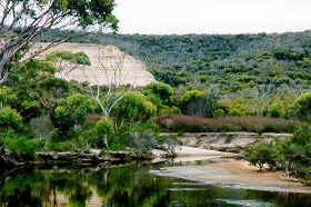
The river rises north of the National Park in undulating sandplain on the edge of the Yilgarn Plateau, about 300 metres above sea level, and between 50 and 100 kilometres from the coast, where much of the drainage is internal to salt lakes. The Fitzgerald River extends north of the belt of farmland into the Lake Magenta Nature Reserve. About 40% of the Fitzgerald River catchment is cleared.
Further south the river cuts through the sandplain to bed-rock as it enters the National Park then winds across the plateau of soft siltstone (spongolite) towards the sea, cutting steep sided gorges en-route.
The river is likely to have been saline before any clearing for agriculture, because of the contribution to flow from salt lakes in its head-waters, and because of the salt stored in the spongolite through which it flows. Salinity was probably least at times of greatest flow. Today, river salinity may have increased as a result of clearing, and sedimentation of the river and estuary may have accelerated.
Nutrient pollution is much lower in these rivers than in rivers with more extensively cleared catchments such as Gairdner and Pallinup.
In 2005 a project (Our Living Rivers) was set up to collect and analyse data, enabling the Department of Water to monitor the health of the river over time and help determine what systems need better protection. In spring 2006 and 2007 samples were taken from the river system to assess the quality of the water and habitat as well as the presence of fish and macroinvertebrates. Eight sites were sampled on the Fitzgerald River system.
Further Information:
South Coast Regional Land and Water Care Strategy: The Fitzgerald-Biosphere Sub-region. Prepared by the South Coast Regional Assessment Panel and the South Coast Regional Initiative Planning Team March 1997.