|
Frankland River |
| Frankland River at a glance | |||
| Catchment area: | 4806 square kilometres north of highway;
916 square kilometres south of highway |
||
| Average annual catchment rainfall: | 400-800 millimetres in the north;
800-1400 millimetres in the south |
||
| River length (including Gordon): | 400 kilometres | ||
| Annual discharge volume into inlet: | 558M cubic metres | ||
| Extent of tidal influence: | 12 kilometres | ||
| Percentage cleared: | 85% | ||
| Data selection | |||
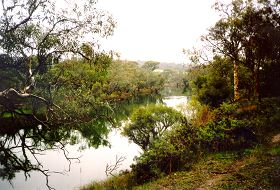
The Frankland River, along with the Walpole and Deep Rivers, drain into Nornalup Inlet, a deep, well-flushed estuary permanently open to the sea.
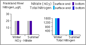
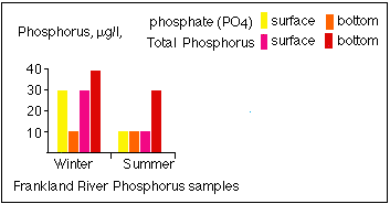
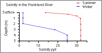
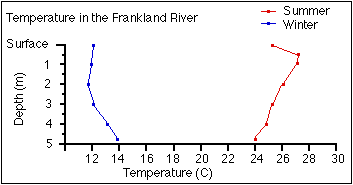
The Gordon River, a tributary of the Frankland has its head-waters on the flat Yilgarn Plateau about 300 metres above sea level, in agricultural areas south-west of Broomehill, with rainfall less than 500 millimetres per annum. Further south, the Frankland River flows through incised valleys in the southern forests, draining into Nornalup Inlet, where the annual rainfall is 1400 mm. About 85% of the Frankland River's catchment, mostly about the 800 mm rainfall isohyet, is cleared for agriculture. This part of the river system is severely degraded by loss of fringing vegetation, bank erosion and sedimentation of pools. Eutrophic changes in the river pools in summer and autumn may occur from time to time. In addition, clearing in the upper catchment has increased the flow of saline water into the river, so that the river water is still brackish when it enters Nornalup Inlet, despite the large contribution of fresh water from the high rainfall, forested lower catchment. The Frankland River is saline, with an average of two ppt over the ten years 1973-1982, but salinity has increased progressively over time, particularly in the upper reaches of the river. The deep water samples show salinity readings greater than 30 ppt in summer, with lower salinity water flowing over the surface.
In 2005 a project (Our Living Rivers) was set up to collect and analyse data, enabling the Department of Water to monitor the health of the river over time and help determine what systems need better protection. In spring 2006 and 2007 samples were taken from the river system to assess the quality of the water and habitat as well as the presence of fish and macroinvertebrates. Four sites were sampled on the Frankland River and one site on Elise Brook. In addition three sites along the Gordon River, one site on Wadjekanup Creek, one on Slab Hut Gully and one on Towerlup Brook were sampled.
Fine sediment from the agricultural area is carried the full length of the river and either settles in Nornalup Inlet or is flushed out to sea. Coarse sediment is trapped in river pools in the upper catchment, and may also be accumulating in pools in the forested part of the river.
Nutrient loads discharged into the inlet are low, probably due to the dilution as the river passes through the high rainfall zone near the coast. There is some clearing in the lower catchment near the coast, but effects on the river are minor.
 |
 |
 |
|
 |
|
 |
|
The section of river south of Muirs Highway to Nornalup Inet has high value for recreation.
Further Information:
An Inventory of Information on the Estuaries and Coastal Lagoons of South Western Australia. Nornalup and Walpole Inlets and other estuaries of the Deep and Frankland Rivers. Environmental Protection Authority; Perth, Western Australia. Estuarine Studies Series Number 2: March 1988