|
Phillips River |
| Phillips River at a glance | |||
| Catchment area: | 2307 square kilometres |
||
| Average annual catchment rainfall: | 425 millimetres | ||
| River length: | 120 kilometres | ||
| Annual discharge into Culham Inlet: | 7300 Megalitres | ||
| Percentage cleared: | 35% | ||
| River health: | naturally saline | ||
|
|
|
|
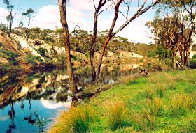
The Phillips River is approximately 120 kilometres long and drains from north east of Mount Madden to Culham Inlet on the South Coast. It rises on the sandplain north of the South Coast highway in a poorly drained area of internal drainage. The river then traverses along a fault line through the Quartzite rocks of the Mount Barren Beds. Finally the river reaches Culham Inlet which is recognised for its scenic, and amenity value, black bream fishing and as a waterbird habitat. The inlet is listed in 'A Directory of Important Wetlands in Australia' (Australian Nature Conservation Agency 1996). The inlet is better described as a coastal lagoon or salt lake because it rarely has access to the sea and is occasionally completely dry.
The headwater of the Phillips River rises between Ravensthorpe and Mt Madden, which is largely cleared for agriculture. Most clearing was undertaken post World War 11 in the late 1950s early 1960s. The Phillips River catchment is 35% cleared. The southern third of the river is within Fitzgerald River National Park, a large (329 000 hectares) national park recognised internationally for its scenic values, extremely high plant species diversity and rare and endangered fauna. The entire catchment is within the Fitzgerald Biosphere Reserve; which is recognised by UNESCO as well as State and Commonwealth governments.
The Phillips River only flows for a short period of the year, often after rainfall events. In dry periods, the river does not flow except for some groundwater fed river pools, which retain water all year round. These river pools often have a dense growth of shrubs and trees between them. The smaller pools may dry out in summer but larger pools, many a kilometre or so long, can be several metres deep and always hold water. The larger permanent pools support a number of plant and animal species Black Bream (Acanthopagdrus butcheri), Spotted minnow (Galaxias maculatus), Blue-spotted Goby (Pseudogobius olorum) and Hardyhead (Leptatherina wallacei).
The Phillips River is naturally saline and varies from almost fresh to a concentration greater than seawater. The salinity of the river is often less during winter or high flow events, to summer where evaporation increases the salinity of the water. The Department of Environment's river assessment recorded salinity levels in some pools with concentrations three times the salinity of seawater.
Flood event of January 2000
In January 2000 the Phillips River flooded due to above average and widespread rainfall in the catchment. Examination of rainfall figures for Ravensthorpe recorded an official rainfall of 224.4 millimetres, which is the highest monthly figure since records began in 1902. The flood flow lasted until late April 2000. The flood was initiated by 103 millimetres over 14/15 January and maintained by a second pulse of 137.2 mm over the period 22-26 January. The previous highest monthly record was 163.3 mm in January 1939.
The flooding caused widespread and prolonged disruption to the district including washing away the bridge embankment at the Highway One bridge and making the highway impassable for five weeks. The causeway across the mouth of the Culham Inlet causeway was washed away. There was damage to local river crossings at Aerodrome, Bridger, and Long Creek Roads as well as localised damage to creek crossings of most major sealed roads.
The flood affected many aspects of the river itself including shifting sediment, causing erosion of river banks, invasion of weeds, destruction of some riparian vegetation, and chemical changes to river water. Flooding is however a natural process for rivers and our plants and animals have often adapted to these events. Flora species such as Yates germinate after floodwaters have subsided. Many of our aquatic fauna such as our native fish species Galaxias maculatus breeds in floodwaters as it spills onto the floodplains. Floods also scour pools out which provide permanent pools for drought refuge.
State of the Phillips River
The Water and Rivers Commission conducted a river assessment in 2000. The survey recorded that the Phillips River is in excellent condition. The river has significant ecological values as it forms an important vegetative corridor between the coastal reserve and Mount Madden to the north. It also forms an important link to the Fitzgerald River National Park, which is an internationally recognised. The river is entirely protected from stock, and has few weeds along the main corridor. There are no major areas of erosion or sedimentation of river pools compared to many other rivers in the South Coast. The river also has considerable habitat values with many river pools, overhanging vegetation, riffle zones, freshwater pools and other features of the river which provides habitat for many varied flora and fauna which rely on the river.
The survey recorded the condition of foreshore vegetation. A remarkable 77% of the vegetation condition is graded as excellent condition (A grade). The survey recorded 12% in good condition (B grade) with only 4% in C grade condition. Considerable works had been undertaken by landholders to protect the upper area of the Phillips River with 7% revegetated.
The major degradation issues include invasive weeds, which mainly occur in the south of the river and salinisation and/or waterlogging, which mainly occurs in the north. The worst degradation by weeds occurs at three well-defined, relatively small nodes where historical agricultural practices including grazing and movement of sheep has occurred. This has resulted in the natural shrub understorey being completely replaced by annual grasses. There is also African Boxthorn, which is starting to out-compete native vegetation in some sections.
The effects of salinisation and/or waterlogging are most apparent in the north where extensive areas of Melaleuca shrubland are being replaced by samphire flat. Elsewhere along the river there are sporadic deaths of Swamp Yate trees, and further examination is required to determine whether salinisation and/or waterlogging, or for example insect attack is the cause of the decline.
The survey recorded that rabbits are present throughout the river, however they were only abundant in one section. No feral animals were recorded in the assessment although feral goats, sheep and pigs have been reported in sections of the river.
The river channel is generally stable and there are no severe areas of channel erosion. It is likely that clearing has resulted in an increase in the volume and rate of river flow. Sedimentation of riverpools is a concern as pools are important drought refuges for many aquatic flora and fauna. At this stage sedimentation does not appear a major issue however there is no hard data to show what effect it may have had on river pools or Culham Inlet. There is evidence that some sediment is entering the main channel from tributaries in the catchment.
There have been few water quality samples taken on the Phillips River, but there is a concern that the salinity levels have increased in the river. There are also rising groundwater levels and subsequent salinisation and/or waterlogging in the catchment. At present 11.2% of cleared land is affected, this is expected to increase to 18.3% by 2010-2020 and to 22.7% when equilibrium is reached. Rising groundwater levels in the catchment could have significant impacts on the river in the future.
In summary, the results of this survey indicate that the river is presently in excellent condition. There are early stages of system degradation however some of these can be managed on a local scale. Catchment wide issues such as salinity and waterlogging need to be addressed at a catchment scale.
Management Recommendations
Specific recommendations for management are included in the Phillips River Action Plan produced by the Water and Rivers Commission in 2001. Summaries of these are provided below.
| Recommendations | |
|---|---|
| Protect Foreshore vegetation |
|
| Improve water quality |
|
| Minimise the impact of salinity and waterlogging on the health of the river |
|
| Improve stability of river crossings |
|
| Protect the river from feral animals |
|
| Increase awareness of ecological, cultural and heritage values of the Phillips River. |
|
South Coast Regional Land and Water Care Strategy: The Fitzgerald-Biosphere Sub-region. Prepared by: the South Coast Regional Assessment Panel and the South Coast Regional Initiative Planning Team March 1997.