|
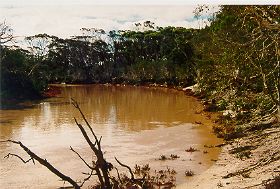
West River |
|
|
|
|
The upper catchment of the West River is cleared for agriculture. Most clearing of the catchment was undertaken post World War II in the late 1950s early 1960s. The lower sections of the West River are within Fitzgerald River National Park, a large (329 000 hectares) national park recognised internationally for its scenic values, extremely high plant species diversity and rare and endangered fauna. The upper catchment is located within the Fitzgerald Biosphere Reserve which is recognised by UNESCO as well as State and Commonwealth governments.
The West River only flows for a short period of the year, often after rainfall events. In dry periods, the river does not flow except for some groundwater fed river pools, which retain water all year round. These river pools often have a dense growth of shrubs and trees between them. The smaller pools may dry out in summer but larger pools, many a kilometre or so long, can be several metres deep and always hold water. The larger permanent pools support a number of plant and animal species - black bream (Acanthopagdrus butcheri), spotted minnow (Galaxias maculatus), blue-spotted goby (Pseudogobius olorum) and hardyhead (Leptatherina wallacei).
Water quality
The West River is naturally saline and varies from almost fresh to a concentration greater than seawater. There is no gauging station on the West River, some water quality samples have been taken since 1971. The older data is from the crossing on the Old Ongerup Road, and the later years from the highway bridge. These are shown below:
| Collected Date | Cl (sol) mg/L | Conductivity (in situ) mS/m | Conductivity (lab) mS/m | Discharge rate (estimated) m3/s | Total Nitrogen mg/L | Dissolved Oxygen mg/L | Total Phosphorous mg/L | Water temperature deg C (in situ) | pH |
|---|---|---|---|---|---|---|---|---|---|
| 15/11/1971 | 655.0 | 0.142 | 18.3 | ||||||
| 02/12/1971 | 679.0 | 0.042 | 23.3 | ||||||
| 01/05/1972 | 3339.3 | 0.000 | 18.3 | ||||||
| 20/05/1974 | 2911.6 | 0.016 | 14.0 | ||||||
| 05/07/1974 | 4246.0 | 0.020 | 10.2 | ||||||
| 03/12/1974 | 5520.0 | 0.008 | 31.0 | ||||||
| 03/02/1975 | 6673.0 | 0.001 | 24.0 | ||||||
| 18/04/1975 | 8007.0 | 0.001 | 14.0 | ||||||
| 23/05/1975 | 2002.0 | 0.050 | 11.0 | ||||||
| 21/08/1975 | 4125.0 | 583 | 0.003 | 11.0 | |||||
| 27/11/1975 | 6066.0 | 1550 | 0.002 | 24.0 | |||||
| 06/05/1976 | 8250.0 | 1725 | 0.001 | 13.0 | |||||
| 02/09/1976 | 2062.0 | 480 | 0.005 | 17.0 | |||||
| 15/10/1976 | 4368.0 | 1065 | 0.001 | 20.0 | |||||
| 25/11/1976 | 6521.0 | 0.001 | 20.0 | ||||||
| 12/01/1977 | 0.000 | ||||||||
| 10/02/1977 | 0.000 | ||||||||
| 16/03/1977 | 0.000 | ||||||||
| 22/06/1977 | 6127.0 | 2820 | 0.010 | 12.0 | |||||
| 04/08/1977 | |||||||||
| 09/09/1977 | 6123.3 | 1710 | 0.001 | 7.8 | 8.100 | ||||
| 18/10/1977 | 5174.2 | 1510 | 27.0 | 7.600 | |||||
| 30/11/1977 | 4108.2 | 1240 | 0.001 | 25.0 | 7.400 | ||||
| 12/01/1978 | 5100.0 | 1720 | 0.000 | 27.2 | 8.000 | ||||
| 19/06/1997 | 4970 | 0.003 | 9.300 | 11.8 | 8.300 | ||||
| 14/07/1997 | 4440 | 0.019 | 12.500 | 11.2 | 8.400 | ||||
| 11/09/1997 | 12.000 | 4.232 | 0.535 | 12.6 | |||||
| 11/09/1997 | 1040 | 12.000 | 8.500 | 12.6 | 8.200 | ||||
| 15/10/1997 | 2.000 | 0.040 | |||||||
| 24/07/1998 | 3870 | 0.005 | 7.7 | 8.500 |
The West River is naturally saline. The salinity of the river is often less during winter or high flow events, but summer evaporation increases the salinity of the water. Records show that salinity ranges from 480 - 4440 mS/m (seawater is 5100 mS/m). The salinity is likely to be higher than this in pools due to evaporation.
Discharge rates from the West River were recorded as zero during many dry periods, and the highest recorded was 12 cubic metres/second in 1997. These data are unlikely to have captured flood or high flow events. Extrapolating data from nearby catchments, runoff to the estuaries averages about 6mm from cleared catchments but probably less than that from bush land in the park. Most flow into the Culham Inlet is from heavy rainfall events. Floods transport large volumes of sediment, which is evident along the main channel of the West River.
There has been few nutrient samples taken, however those samples taken in 1997 showed total phosphorous and total nitrogen levels higher than the ANZECC guidelines. Further sampling is required to identify nutrient levels throughout the catchment.
State of the West River
There has been no assessment completed to determine the condition of the West River and there is little information on the condition of the river. In comparison to other rivers in the south coast, it is likely that the river is in excellent condition.
There is evidence that the West River, particularly in the cleared section of the catchment is showing some signs of degradation. The river has a wide buffer of vegetation along most sections of the river. This appears to become thinner towards the upper catchment and in areas where the buffer is not adequate - weed invasion and vegetation decline is more evident. There are also sections of vegetation along the main channel, which are showing signs of degradation due to salinisation and waterlogging. This is likely to continue to get worse based on predicted groundwater rises in the catchment.
It is likely that clearing has resulted in an increase in the volume and rate of river flow, resulting in changes to the river form. There is evidence that the riverbanks are unstable in some locations resulting in sedimentation of the main channel and some river pools. Sedimentation of riverpools is a concern as pools are important drought refuges for many aquatic flora and fauna and terrestrial fauna.
There have been few water quality samples taken on the West River, but there is a concern that the salinity levels have increased in the river. There are also rising groundwater levels and subsequent salinisation and/or waterlogging in the catchment.
In summary, the West River is likely to be in excellent condition, with early stages of system degradation, which can be managed on a local scale. Catchment wide issues such as salinity and waterlogging need to be addressed at a catchment scale.
| Protect the foreshore vegetation of the West River and major tributaries in the catchment |
|
| Improve water quality |
|
| Minimise the impact of salinity and waterlogging on the health of the river |
|
| Protect the river from feral animals |
|
| Increase awareness of ecological, cultural and heritage values of the West River |
|
Further Information:
South Coast Regional Land and Water Care Strategy: The Fitzgerald-Biosphere Sub-region. Prepared by: the South Coast Regional Assessment Panel and the South Coast Regional Initiative Planning Team March 1997.